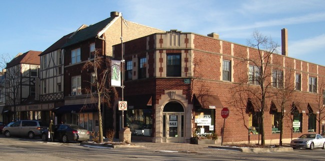
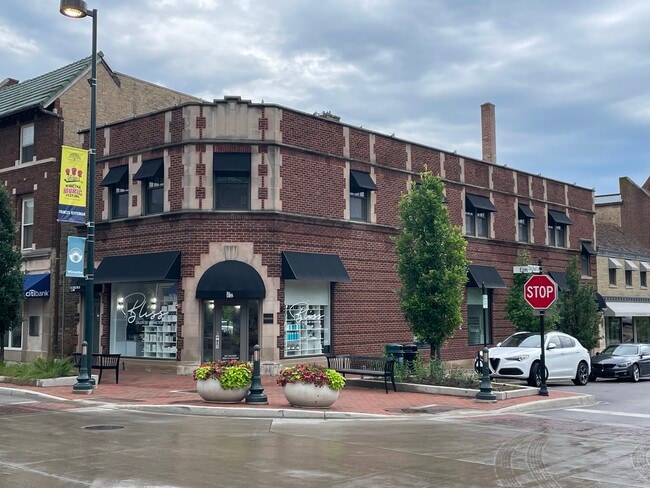
Property Record
818 Elm St, Winnetka, IL 60093

Current Lease Availabilities
NEARBY LISTINGS FOR SALE OR LEASE
Property Detail
818 Elm St
Chicago-Naperville-Elgin, IL-IN-WI
Wilson & Dales N2 Blk
05-20-212-001-0000
N 111 FT W 27 FT OF LOT 1 IN WILSON & DALES SUB N2 OF BLK 26 IN WINNE TKA NE4 OF SEC20+ T42N R13E 3P
Miscresidentialimprovement
Cook
X
Illinois
17031C0251K
1
2023
0.05 AC
2024
Central North
800500
Chicago
3,838 SF
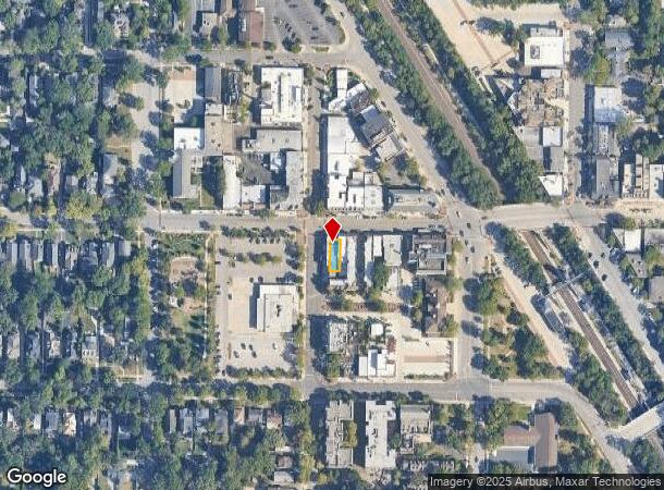
DEMOGRAPHICS near 818 Elm St
1 Mile
3 Mile
5 Mile
2024 Total Population
9,734
62,093
191,219
2029 Population
9,462
60,456
186,732
Pop Growth 2024-2029
(2.79%)
(2.64%)
(2.35%)
Average Age
40
42
42
2024 Total Households
3,179
21,417
68,663
HH Growth 2024-2029
(3.05%)
(2.93%)
(2.54%)
Median Household Inc
$240,471
$189,002
$117,314
Avg Household Size
3.00
2.80
2.60
2024 Avg HH Vehicles
2.00
2.00
2.00
Median Home Value
$1,044,811
$837,676
$605,618
Median Year Built
1948
1955
1958
Nearby Places
Map Layers
Map Styles
 Street
 Aerial
- Restaurants
- Banks
- Shops
- Fitness
- Groceries
PUBLIC TRANSPORTATION
COMMUTER RAIL
Winnetka Station (Union Pacific North Line - Northeast Illinois Regional Commuter Railroad (Metra))
DRIVE
WALK
Distance
Winnetka Station (Union Pacific North Line - Northeast Illinois Regional Commuter Railroad (Metra))
1 min
14 min
0.1 mi
Hubbard Woods Station (Union Pacific North Line - Northeast Illinois Regional Commuter Railroad (Metra))
DRIVE
WALK
Distance
Hubbard Woods Station (Union Pacific North Line - Northeast Illinois Regional Commuter Railroad (Metra))
4 min
19 min
1.0 mi
AIRPORT
Chicago O'Hare International
DRIVE
WALK
Distance
Chicago O'Hare International
31 min
18.1 mi
Chicago Midway International
DRIVE
WALK
Distance
Chicago Midway International
44 min
30.9 mi
Freight Ports
Port of Baltimore
DRIVE
WALK
Distance
Port of Baltimore
1 min
615.2 mi
Nearby Properties
Address
Land Use
TOTAL SIZE
Lot Size
Zoning
Address
Land Use
TOTAL SIZE
Lot Size
Zoning
172,538 SF
5.60 AC
Address
Land Use
TOTAL SIZE
Lot Size
Zoning
6.90 AC
Address
Land Use
TOTAL SIZE
Lot Size
Zoning
0.84 AC
Address
Land Use
TOTAL SIZE
Lot Size
Zoning
172,544 SF
7.22 AC
Address
Land Use
TOTAL SIZE
Lot Size
Zoning
60,301 SF
3.35 AC
Address
Land Use
TOTAL SIZE
Lot Size
Zoning
128,372 SF
5.21 AC
Address
Land Use
TOTAL SIZE
Lot Size
Zoning
1.62 AC
Address
Land Use
TOTAL SIZE
Lot Size
Zoning
223,203 SF
3.75 AC
Address
Land Use
TOTAL SIZE
Lot Size
Zoning
94,063 SF
1.61 AC
Address
Land Use
TOTAL SIZE
Lot Size
Zoning
1.69 AC
Address
Land Use
TOTAL SIZE
Lot Size
Zoning
47,283 SF
1.18 AC
Address
Land Use
TOTAL SIZE
Lot Size
Zoning
63,298 SF
3.30 AC
Address
Land Use
TOTAL SIZE
Lot Size
Zoning
165,504 SF
4.71 AC
Address
Land Use
TOTAL SIZE
Lot Size
Zoning
126.61 AC
Address
Land Use
TOTAL SIZE
Lot Size
Zoning
1.62 AC
Address
Land Use
TOTAL SIZE
Lot Size
Zoning
130,034 SF
0.92 AC
Address
Land Use
TOTAL SIZE
Lot Size
Zoning
47,395 SF
6.97 AC
Address
Land Use
TOTAL SIZE
Lot Size
Zoning
93,002 SF
2.26 AC
Address
Land Use
TOTAL SIZE
Lot Size
Zoning
Address
Land Use
TOTAL SIZE
Lot Size
Zoning
55,120 SF
1.73 AC
Address
Land Use
TOTAL SIZE
Lot Size
Zoning
97.02 AC
Address
Land Use
TOTAL SIZE
Lot Size
Zoning
35,252 SF
2.02 AC
Address
Land Use
TOTAL SIZE
Lot Size
Zoning
65.13 AC
Address
Land Use
TOTAL SIZE
Lot Size
Zoning
Address
Land Use
TOTAL SIZE
Lot Size
Zoning
36,892 SF
2.65 AC
Address
Land Use
TOTAL SIZE
Lot Size
Zoning
15,770 SF
0.39 AC
Address
Land Use
TOTAL SIZE
Lot Size
Zoning
46,400 SF
1.92 AC
Address
Land Use
TOTAL SIZE
Lot Size
Zoning
32,671 SF
0.53 AC
Address
Land Use
TOTAL SIZE
Lot Size
Zoning
21,152 SF
0.54 AC
Address
Land Use
TOTAL SIZE
Lot Size
Zoning
38,350 SF
2.40 AC
The World's #1 Commercial Real Estate Marketplace
Connect with us
© 2025 CoStar Group
The information above has been obtained from sources believed reliable. While we do not doubt its accuracy we have not verified it and make no guarantee, warranty or representation about it. It is your responsibility to independently confirm its accuracy and completeness. Any projections, opinions, assumptions, or estimates used are for example only and do not represent the current or future performance of the property. The value of this transaction to you depends on tax and other factors which should be evaluated by your tax, financial, and legal advisors. You and your advisors should conduct a careful, independent investigation of the property to determine to your satisfaction the suitability of the property for your needs.