Property Record
818 White Mountain Hwy, Milton, NH 03851
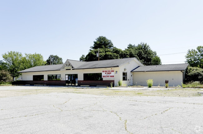

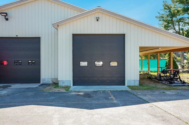
This Property Is For Sale
NEARBY LISTINGS FOR SALE OR LEASE
Property Detail
818 White Mountain Hwy
Commercialbuilding
Strafford
X
New Hampshire
23031C0361G
0.85 AC
2024
Strafford County
2024
Boston
088000
Boston-Cambridge-Newton, MA-NH
3,183 SF
MLTN-000032-000143
DEMOGRAPHICS near 818 White Mountain Hwy
1 Mile
3 Mile
5 Mile
2024 Total Population
1,171
3,830
12,748
2029 Population
1,220
3,966
13,297
Pop Growth 2024-2029
+ 4.18%
+ 3.55%
+ 4.31%
Average Age
46
43
43
2024 Total Households
508
1,548
5,075
HH Growth 2024-2029
+ 4.13%
+ 3.62%
+ 4.33%
Median Household Inc
$103,465
$105,175
$93,333
Avg Household Size
2.30
2.40
2.50
2024 Avg HH Vehicles
2.00
2.00
2.00
Median Home Value
$311,392
$283,556
$262,473
Median Year Built
1980
1981
1981
Nearby Places
Map Layers
Map Styles
 Street
 Aerial
- Restaurants
- Banks
- Shops
- Fitness
- Groceries
PUBLIC TRANSPORTATION
AIRPORT
Portsmouth International at Pease
DRIVE
WALK
Distance
Portsmouth International at Pease
45 min
30.6 mi
Freight Ports
Portland, ME
DRIVE
WALK
Distance
Portland, ME
78 min
52.2 mi
Nearby Properties
Address
Land Use
TOTAL SIZE
Lot Size
Zoning
Address
Land Use
TOTAL SIZE
Lot Size
Zoning
123,860 SF
8.75 AC
IND/CO
Address
Land Use
TOTAL SIZE
Lot Size
Zoning
3,000 SF
225 AC
LOW DE
Address
Land Use
TOTAL SIZE
Lot Size
Zoning
61,383 SF
9.60 AC
HIGH D
Address
Land Use
TOTAL SIZE
Lot Size
Zoning
56.70 AC
LOW DE
Address
Land Use
TOTAL SIZE
Lot Size
Zoning
60,884 SF
45.18 AC
LOW DE
Address
Land Use
TOTAL SIZE
Lot Size
Zoning
35,049 SF
4.61 AC
HIGH D
Address
Land Use
TOTAL SIZE
Lot Size
Zoning
6,000 SF
2.30 AC
IND/CO
Address
Land Use
TOTAL SIZE
Lot Size
Zoning
2,583 SF
1.30 AC
LOW DE
Address
Land Use
TOTAL SIZE
Lot Size
Zoning
10,750 SF
2 AC
IND/CO
Address
Land Use
TOTAL SIZE
Lot Size
Zoning
5,106 SF
3.65 AC
IND/CO
Address
Land Use
TOTAL SIZE
Lot Size
Zoning
14,895 SF
5.92 AC
IND/CO
Address
Land Use
TOTAL SIZE
Lot Size
Zoning
8,108 SF
3.18 AC
IND/CO
Address
Land Use
TOTAL SIZE
Lot Size
Zoning
5,413 SF
1.73 AC
HIGH D
Address
Land Use
TOTAL SIZE
Lot Size
Zoning
2,109 SF
1.80 AC
HIGH D
Address
Land Use
TOTAL SIZE
Lot Size
Zoning
12,447 SF
7.16 AC
IND/CO
Address
Land Use
TOTAL SIZE
Lot Size
Zoning
23,675 SF
5.19 AC
IND/CO
Address
Land Use
TOTAL SIZE
Lot Size
Zoning
5,100 SF
7.18 AC
IND/CO
Address
Land Use
TOTAL SIZE
Lot Size
Zoning
8.06 AC
LOW DE
Address
Land Use
TOTAL SIZE
Lot Size
Zoning
33.99 AC
COMM/R
Address
Land Use
TOTAL SIZE
Lot Size
Zoning
0.23 AC
LOW DE
Address
Land Use
TOTAL SIZE
Lot Size
Zoning
8,417 SF
3.09 AC
IND/CO
Address
Land Use
TOTAL SIZE
Lot Size
Zoning
12,863 SF
2.95 AC
HIGH D
Address
Land Use
TOTAL SIZE
Lot Size
Zoning
2,811 SF
71.23 AC
LOW DE
Address
Land Use
TOTAL SIZE
Lot Size
Zoning
485 SF
7.45 AC
LOW DE
Address
Land Use
TOTAL SIZE
Lot Size
Zoning
4,600 SF
0.63 AC
HIGH D
Address
Land Use
TOTAL SIZE
Lot Size
Zoning
1,922 SF
0.44 AC
LOW DE
Address
Land Use
TOTAL SIZE
Lot Size
Zoning
7,328 SF
2.10 AC
HIGH D
Address
Land Use
TOTAL SIZE
Lot Size
Zoning
5,058 SF
1.32 AC
LOW DE
Address
Land Use
TOTAL SIZE
Lot Size
Zoning
4,634 SF
1.21 AC
HIGH D
Address
Land Use
TOTAL SIZE
Lot Size
Zoning
1,305 SF
0.83 AC
LOW DE
The World's #1 Commercial Real Estate Marketplace
Connect with us
© 2026 CoStar Group
The information above has been obtained from sources believed reliable. While we do not doubt its accuracy we have not verified it and make no guarantee, warranty or representation about it. It is your responsibility to independently confirm its accuracy and completeness. Any projections, opinions, assumptions, or estimates used are for example only and do not represent the current or future performance of the property. The value of this transaction to you depends on tax and other factors which should be evaluated by your tax, financial, and legal advisors. You and your advisors should conduct a careful, independent investigation of the property to determine to your satisfaction the suitability of the property for your needs.