Property Record
8180 Shore Dr, Norfolk, VA 23518


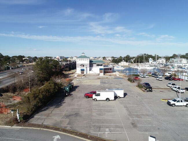
This Property Is For Sale
NEARBY LISTINGS FOR SALE OR LEASE
-
-
View all Norfolk listings for sale on LoopNet.com
Property Detail
8180 Shore Dr
00001677
Wisteria Place Sd
Restaurantbuilding
PARCEL B-1, 0.8524 AC
AE
Norfolk City
5101040037H
Virginia
2025
0.85 AC
2025
Airport/Northampton
006604
Hampton Roads
11,872 SF
Virginia Beach-Norfolk-Newport News, VA-NC
DEMOGRAPHICS near 8180 Shore Dr
1 Mile
3 Mile
5 Mile
2024 Total Population
9,918
51,717
177,906
2029 Population
9,881
50,699
174,325
Pop Growth 2024-2029
(0.37%)
(1.97%)
(2.01%)
Average Age
40
38
38
2024 Total Households
4,473
21,685
69,739
HH Growth 2024-2029
(0.60%)
(2.27%)
(2.30%)
Median Household Inc
$68,630
$66,073
$64,160
Avg Household Size
2.20
2.30
2.30
2024 Avg HH Vehicles
2.00
2.00
2.00
Median Home Value
$366,995
$267,354
$257,783
Median Year Built
1991
1970
1970
Nearby Places
Map Layers
Map Styles
 Street
 Aerial
- Restaurants
- Banks
- Shops
- Fitness
- Groceries
PUBLIC TRANSPORTATION
COMMUTER RAIL
DRIVE
WALK
Distance
16 min
8.4 mi
AIRPORT
Norfolk International
DRIVE
WALK
Distance
Norfolk International
9 min
3.8 mi
Newport News/Williamsburg International
DRIVE
WALK
Distance
Newport News/Williamsburg International
39 min
25.9 mi
Freight Ports
Virginia Port Authority - Norfolk
DRIVE
WALK
Distance
Virginia Port Authority - Norfolk
20 min
8.8 mi
Nearby Properties
Address
Land Use
TOTAL SIZE
Lot Size
Zoning
Address
Land Use
TOTAL SIZE
Lot Size
Zoning
10 SF
207.44 AC
I2
Address
Land Use
TOTAL SIZE
Lot Size
Zoning
116,476 SF
947.43 AC
Address
Land Use
TOTAL SIZE
Lot Size
Zoning
30,036 SF
50.39 AC
Address
Land Use
TOTAL SIZE
Lot Size
Zoning
40.37 AC
R6
Address
Land Use
TOTAL SIZE
Lot Size
Zoning
15.12 AC
Address
Land Use
TOTAL SIZE
Lot Size
Zoning
434,920 SF
8.35 AC
A36
Address
Land Use
TOTAL SIZE
Lot Size
Zoning
1 SF
17.15 AC
A24
Address
Land Use
TOTAL SIZE
Lot Size
Zoning
6,572 SF
23.41 AC
Address
Land Use
TOTAL SIZE
Lot Size
Zoning
Address
Land Use
TOTAL SIZE
Lot Size
Zoning
1,020 SF
13.45 AC
R11
Address
Land Use
TOTAL SIZE
Lot Size
Zoning
19.47 AC
86
Address
Land Use
TOTAL SIZE
Lot Size
Zoning
100,550 SF
1.72 AC
Address
Land Use
TOTAL SIZE
Lot Size
Zoning
1,980 SF
1.87 AC
Address
Land Use
TOTAL SIZE
Lot Size
Zoning
179,912 SF
9.08 AC
A36
Address
Land Use
TOTAL SIZE
Lot Size
Zoning
170,152 SF
6.07 AC
PDMU1
Address
Land Use
TOTAL SIZE
Lot Size
Zoning
1 SF
10.60 AC
A18
Address
Land Use
TOTAL SIZE
Lot Size
Zoning
6.96 AC
R11
Address
Land Use
TOTAL SIZE
Lot Size
Zoning
40,323 SF
2.60 AC
Address
Land Use
TOTAL SIZE
Lot Size
Zoning
28,584 SF
7.76 AC
BC1
Address
Land Use
TOTAL SIZE
Lot Size
Zoning
1 SF
0.01 AC
A24
Address
Land Use
TOTAL SIZE
Lot Size
Zoning
15,898 SF
9.91 AC
IN1
Address
Land Use
TOTAL SIZE
Lot Size
Zoning
106,600 SF
2.81 AC
Address
Land Use
TOTAL SIZE
Lot Size
Zoning
168,605 SF
13.32 AC
I1
Address
Land Use
TOTAL SIZE
Lot Size
Zoning
280 SF
16.84 AC
IN1
Address
Land Use
TOTAL SIZE
Lot Size
Zoning
44,880 SF
5.44 AC
R13
Address
Land Use
TOTAL SIZE
Lot Size
Zoning
322,404 SF
18.39 AC
I1
Address
Land Use
TOTAL SIZE
Lot Size
Zoning
24.67 AC
IN1
Address
Land Use
TOTAL SIZE
Lot Size
Zoning
7.28 AC
IN1
Address
Land Use
TOTAL SIZE
Lot Size
Zoning
79,136 SF
0.85 AC
Address
Land Use
TOTAL SIZE
Lot Size
Zoning
3.66 AC
The World's #1 Commercial Real Estate Marketplace
Connect with us
© 2025 CoStar Group
The information above has been obtained from sources believed reliable. While we do not doubt its accuracy we have not verified it and make no guarantee, warranty or representation about it. It is your responsibility to independently confirm its accuracy and completeness. Any projections, opinions, assumptions, or estimates used are for example only and do not represent the current or future performance of the property. The value of this transaction to you depends on tax and other factors which should be evaluated by your tax, financial, and legal advisors. You and your advisors should conduct a careful, independent investigation of the property to determine to your satisfaction the suitability of the property for your needs.