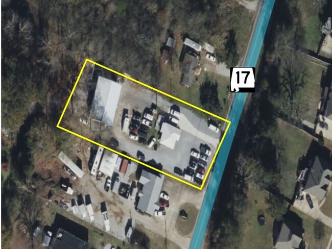
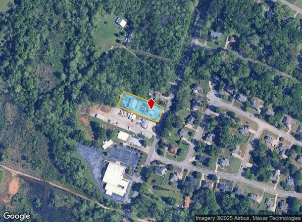
Property Record
8182 Highway 17, Alabaster, AL 35114
NEARBY LISTINGS FOR SALE OR LEASE
Property Detail
8182 Highway 17
Birmingham-Hoover, AL
Shelby
23-2-09-0-001-012-000
Alabama
Sfr
0.69 AC
A
I-65 Corr/S Shelby County
01117C0380E
Birmingham
665 SF
DEMOGRAPHICS near 8182 Highway 17
1 Mile
3 Mile
5 Mile
2024 Total Population
4,232
25,760
58,570
2029 Population
4,587
27,906
63,450
Pop Growth 2024-2029
+ 8.39%
+ 8.33%
+ 8.33%
Average Age
39
39
39
2024 Total Households
1,466
8,934
20,802
HH Growth 2024-2029
+ 8.53%
+ 8.51%
+ 8.49%
Median Household Inc
$101,823
$84,588
$87,255
Avg Household Size
2.90
2.80
2.80
2024 Avg HH Vehicles
2.00
2.00
2.00
Median Home Value
$257,918
$222,031
$237,377
Median Year Built
2003
1992
1995
Nearby Places
Map Layers
Map Styles
 Street
 Aerial
- Restaurants
- Banks
- Shops
- Fitness
- Groceries
PUBLIC TRANSPORTATION
AIRPORT
Birmingham-Shuttlesworth International
DRIVE
WALK
Distance
Birmingham-Shuttlesworth International
45 min
32.3 mi
Freight Ports
Port of Mobile
DRIVE
WALK
Distance
Port of Mobile
264 min
238.7 mi
SALE & LEASE HISTORY
LISTING DATE
SALE/LEASE

Mar 17, 2023
For Sale
Nearby Properties
Address
Land Use
TOTAL SIZE
Lot Size
Zoning
Address
Land Use
TOTAL SIZE
Lot Size
Zoning
1,763 SF
21.99 AC
Address
Land Use
TOTAL SIZE
Lot Size
Zoning
61,602 SF
145.23 AC
Address
Land Use
TOTAL SIZE
Lot Size
Zoning
11,192 SF
26.78 AC
Address
Land Use
TOTAL SIZE
Lot Size
Zoning
226,790 SF
40 AC
Address
Land Use
TOTAL SIZE
Lot Size
Zoning
161,753 SF
25 AC
Address
Land Use
TOTAL SIZE
Lot Size
Zoning
84,355 SF
15.65 AC
Address
Land Use
TOTAL SIZE
Lot Size
Zoning
1,388 SF
17.81 AC
Address
Land Use
TOTAL SIZE
Lot Size
Zoning
120,043 SF
30 AC
Address
Land Use
TOTAL SIZE
Lot Size
Zoning
77,365 SF
24.97 AC
Address
Land Use
TOTAL SIZE
Lot Size
Zoning
43,903 SF
10.21 AC
Address
Land Use
TOTAL SIZE
Lot Size
Zoning
41,120 SF
10.24 AC
Address
Land Use
TOTAL SIZE
Lot Size
Zoning
11,668 SF
18.72 AC
Address
Land Use
TOTAL SIZE
Lot Size
Zoning
42,097 SF
8.03 AC
Address
Land Use
TOTAL SIZE
Lot Size
Zoning
26,980 SF
3.50 AC
Address
Land Use
TOTAL SIZE
Lot Size
Zoning
6,136 SF
18 AC
Address
Land Use
TOTAL SIZE
Lot Size
Zoning
21,160 SF
20.19 AC
Address
Land Use
TOTAL SIZE
Lot Size
Zoning
60,800 SF
4.27 AC
Address
Land Use
TOTAL SIZE
Lot Size
Zoning
32,815 SF
6.09 AC
Address
Land Use
TOTAL SIZE
Lot Size
Zoning
18,299 SF
12.35 AC
Address
Land Use
TOTAL SIZE
Lot Size
Zoning
9,642 SF
9.11 AC
Address
Land Use
TOTAL SIZE
Lot Size
Zoning
47,835 SF
4.73 AC
Address
Land Use
TOTAL SIZE
Lot Size
Zoning
31,112 SF
7.53 AC
Address
Land Use
TOTAL SIZE
Lot Size
Zoning
Address
Land Use
TOTAL SIZE
Lot Size
Zoning
900 SF
5.18 AC
Address
Land Use
TOTAL SIZE
Lot Size
Zoning
14,412 SF
2.19 AC
Address
Land Use
TOTAL SIZE
Lot Size
Zoning
14,240 SF
3.50 AC
Address
Land Use
TOTAL SIZE
Lot Size
Zoning
33,730 SF
43.12 AC
Address
Land Use
TOTAL SIZE
Lot Size
Zoning
17,075 SF
5.54 AC
Address
Land Use
TOTAL SIZE
Lot Size
Zoning
43,946 SF
3.81 AC
The World's #1 Commercial Real Estate Marketplace
Connect with us
© 2025 CoStar Group
The information above has been obtained from sources believed reliable. While we do not doubt its accuracy we have not verified it and make no guarantee, warranty or representation about it. It is your responsibility to independently confirm its accuracy and completeness. Any projections, opinions, assumptions, or estimates used are for example only and do not represent the current or future performance of the property. The value of this transaction to you depends on tax and other factors which should be evaluated by your tax, financial, and legal advisors. You and your advisors should conduct a careful, independent investigation of the property to determine to your satisfaction the suitability of the property for your needs.