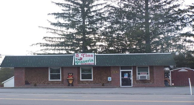
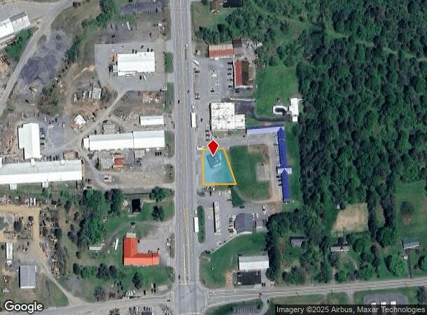
Property Record
8182 State Route 12, Barneveld, NY 13304
NEARBY LISTINGS FOR SALE OR LEASE
-
-
View all Barneveld listings for sale on LoopNet.com
Property Detail
8182 State Route 12
211-002-0002-004-000-0000
GAS STATION & GROCERY & L
Storesoffices
Oneida
X
New York
36065C0418F
4.000
2025
0.28 AC
2024
Outlying Oneida County
024000
Utica/Rome
1,755 SF
Utica-Rome, NY
DEMOGRAPHICS near 8182 State Route 12
1 mile
3 mile
5 mile
2024 Total Population
516
1,828
5,649
2029 Population
502
1,777
5,515
Pop Growth 2024-2029
(2.71%)
(2.79%)
(2.37%)
Average Age
44
44
44
2024 Total Households
211
752
2,318
HH Growth 2024-2029
(2.37%)
(2.93%)
(2.50%)
Median Household Inc
$72,916
$73,476
$73,777
Avg Household Size
2.40
2.40
2.40
2024 Avg HH Vehicles
2.00
2.00
2.00
Median Home Value
$204,225
$204,781
$200,725
Median Year Built
1964
1963
1968
Nearby Places
Map Layers
Map Styles
 Street
 Aerial
Transit
 Traffic
 Biking
Places
Listings with unknown addresses are not visible on the map
- Restaurants
- Banks
- Shops
- Fitness
- Groceries
Nearby Properties
Address
Land Use
TOTAL SIZE
Lot Size
Zoning
Address
Land Use
TOTAL SIZE
Lot Size
Zoning
107.45 AC
02 - SINGL
Address
Land Use
TOTAL SIZE
Lot Size
Zoning
3.13 AC
01 - NOT Z
Address
Land Use
TOTAL SIZE
Lot Size
Zoning
93.10 AC
46
Address
Land Use
TOTAL SIZE
Lot Size
Zoning
02 - SINGL
Address
Land Use
TOTAL SIZE
Lot Size
Zoning
15,000 SF
2.50 AC
01 - NOT Z
Address
Land Use
TOTAL SIZE
Lot Size
Zoning
1,078 SF
21.07 AC
02 - SINGL
Address
Land Use
TOTAL SIZE
Lot Size
Zoning
3,328 SF
34.37 AC
01 - NOT Z
Address
Land Use
TOTAL SIZE
Lot Size
Zoning
696 SF
8.70 AC
Address
Land Use
TOTAL SIZE
Lot Size
Zoning
8,500 SF
1.10 AC
Address
Land Use
TOTAL SIZE
Lot Size
Zoning
5,184 SF
8.90 AC
02 - SINGL
Address
Land Use
TOTAL SIZE
Lot Size
Zoning
11,620 SF
2.09 AC
01 - NOT Z
Address
Land Use
TOTAL SIZE
Lot Size
Zoning
2,535 SF
47.70 AC
46
Address
Land Use
TOTAL SIZE
Lot Size
Zoning
15,156 SF
6.30 AC
05 - COMME
Address
Land Use
TOTAL SIZE
Lot Size
Zoning
2,238 SF
0.92 AC
Address
Land Use
TOTAL SIZE
Lot Size
Zoning
4,591 SF
27 AC
46
Address
Land Use
TOTAL SIZE
Lot Size
Zoning
48,202 SF
7.60 AC
05 - COMME
Address
Land Use
TOTAL SIZE
Lot Size
Zoning
48,202 SF
7.60 AC
05 - COMME
Address
Land Use
TOTAL SIZE
Lot Size
Zoning
1,440 SF
13.75 AC
03 - MULTI
Address
Land Use
TOTAL SIZE
Lot Size
Zoning
4,352 SF
17 AC
46
Address
Land Use
TOTAL SIZE
Lot Size
Zoning
4,117 SF
84.54 AC
02 - SINGL
Address
Land Use
TOTAL SIZE
Lot Size
Zoning
4,962 SF
17 AC
46
Address
Land Use
TOTAL SIZE
Lot Size
Zoning
25.40 AC
01 - NOT Z
Address
Land Use
TOTAL SIZE
Lot Size
Zoning
0.58 AC
Address
Land Use
TOTAL SIZE
Lot Size
Zoning
02 - SINGL
Address
Land Use
TOTAL SIZE
Lot Size
Zoning
4,200 SF
1.20 AC
05 - COMME
Address
Land Use
TOTAL SIZE
Lot Size
Zoning
4,229 SF
1.75 AC
05 - COMME
Address
Land Use
TOTAL SIZE
Lot Size
Zoning
3,529 SF
1.12 AC
03 - MULTI
Address
Land Use
TOTAL SIZE
Lot Size
Zoning
4,032 SF
23.10 AC
46
Address
Land Use
TOTAL SIZE
Lot Size
Zoning
2,823 SF
17.30 AC
46
Address
Land Use
TOTAL SIZE
Lot Size
Zoning
12,356 SF
3.03 AC
05 - COMME
The World's #1 Commercial Real Estate Marketplace
Connect with us
© 2026 CoStar Group
The information above has been obtained from sources believed reliable. While we do not doubt its accuracy we have not verified it and make no guarantee, warranty or representation about it. It is your responsibility to independently confirm its accuracy and completeness. Any projections, opinions, assumptions, or estimates used are for example only and do not represent the current or future performance of the property. The value of this transaction to you depends on tax and other factors which should be evaluated by your tax, financial, and legal advisors. You and your advisors should conduct a careful, independent investigation of the property to determine to your satisfaction the suitability of the property for your needs.