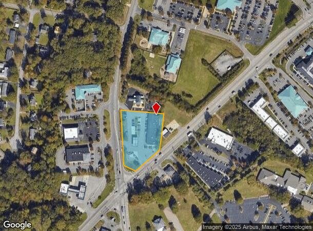
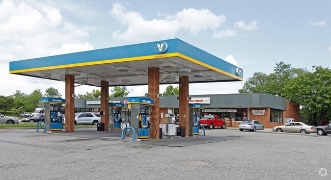
Property Record
8198 Atlee Rd, Mechanicsville, VA 23116

NEARBY LISTINGS FOR SALE OR LEASE
Property Detail
8198 Atlee Rd
Richmond, VA
Metro County Bank
8705-43-7025
METRO COUNTY BANK LOT 2
Commercialnec
Hanover
X
Virginia
51085C0320C
2
2025
1.51 AC
2025
I-95 Chamberlayne/NE
320901
Richmond VA
10,550 SF
DEMOGRAPHICS near 8198 Atlee Rd
1 Mile
3 Mile
5 Mile
2024 Total Population
4,311
39,178
130,425
2029 Population
4,575
41,253
135,216
Pop Growth 2024-2029
+ 6.12%
+ 5.30%
+ 3.67%
Average Age
45
42
42
2024 Total Households
1,753
15,747
53,119
HH Growth 2024-2029
+ 6.27%
+ 5.26%
+ 3.57%
Median Household Inc
$86,946
$83,245
$73,093
Avg Household Size
2.40
2.40
2.40
2024 Avg HH Vehicles
2.00
2.00
2.00
Median Home Value
$288,475
$287,729
$274,341
Median Year Built
1983
1985
1978
Nearby Places
Map Layers
Map Styles
 Street
 Aerial
- Restaurants
- Banks
- Shops
- Fitness
- Groceries
PUBLIC TRANSPORTATION
COMMUTER RAIL
DRIVE
WALK
Distance
16 min
7.5 mi
DRIVE
WALK
Distance
16 min
9.0 mi
AIRPORT
Richmond International
DRIVE
WALK
Distance
Richmond International
21 min
13.3 mi
SALE & LEASE HISTORY
LISTING DATE
SALE/LEASE

Sep 25, 2016
For Lease
Jul 31, 2018
For Lease
Nearby Properties
Address
Land Use
TOTAL SIZE
Lot Size
Zoning
Address
Land Use
TOTAL SIZE
Lot Size
Zoning
2,645,407 SF
116.30 AC
M2-C
Address
Land Use
TOTAL SIZE
Lot Size
Zoning
436,148 SF
12.73 AC
B-1
Address
Land Use
TOTAL SIZE
Lot Size
Zoning
32,407 SF
1.18 AC
UMU
Address
Land Use
TOTAL SIZE
Lot Size
Zoning
1.37 AC
A-1
Address
Land Use
TOTAL SIZE
Lot Size
Zoning
23.50 AC
A-1
Address
Land Use
TOTAL SIZE
Lot Size
Zoning
59,574 SF
313.03 AC
MIXE
Address
Land Use
TOTAL SIZE
Lot Size
Zoning
14.41 AC
A-1
Address
Land Use
TOTAL SIZE
Lot Size
Zoning
2,630 SF
39.79 AC
M-2
Address
Land Use
TOTAL SIZE
Lot Size
Zoning
110,790 SF
37.61 AC
R-2A
Address
Land Use
TOTAL SIZE
Lot Size
Zoning
18.50 AC
RM
Address
Land Use
TOTAL SIZE
Lot Size
Zoning
104,023 SF
98.16 AC
MIXE
Address
Land Use
TOTAL SIZE
Lot Size
Zoning
1,249,190 SF
139.90 AC
M-2
Address
Land Use
TOTAL SIZE
Lot Size
Zoning
29.95 AC
A-1
Address
Land Use
TOTAL SIZE
Lot Size
Zoning
2,145 SF
4.54 AC
B-1
Address
Land Use
TOTAL SIZE
Lot Size
Zoning
160,000 SF
25 AC
M-1
Address
Land Use
TOTAL SIZE
Lot Size
Zoning
112,893 SF
58.52 AC
MIXE
Address
Land Use
TOTAL SIZE
Lot Size
Zoning
Address
Land Use
TOTAL SIZE
Lot Size
Zoning
228,744 SF
21.11 AC
R-5
Address
Land Use
TOTAL SIZE
Lot Size
Zoning
227,008 SF
20.94 AC
R-5
Address
Land Use
TOTAL SIZE
Lot Size
Zoning
23.23 AC
M-1
Address
Land Use
TOTAL SIZE
Lot Size
Zoning
23.60 AC
R-1
Address
Land Use
TOTAL SIZE
Lot Size
Zoning
214,583 SF
32.67 AC
B-3
Address
Land Use
TOTAL SIZE
Lot Size
Zoning
133,200 SF
15.50 AC
R-5
Address
Land Use
TOTAL SIZE
Lot Size
Zoning
84,240 SF
18.48 AC
R-4
Address
Land Use
TOTAL SIZE
Lot Size
Zoning
93,484 SF
14.81 AC
M-1
Address
Land Use
TOTAL SIZE
Lot Size
Zoning
142,560 SF
17.90 AC
R-5
Address
Land Use
TOTAL SIZE
Lot Size
Zoning
107,488 SF
9.89 AC
R-5
Address
Land Use
TOTAL SIZE
Lot Size
Zoning
63,635 SF
4.24 AC
B-1
Address
Land Use
TOTAL SIZE
Lot Size
Zoning
138,484 SF
12.01 AC
R-5
Address
Land Use
TOTAL SIZE
Lot Size
Zoning
423,887 SF
63.71 AC
M-1
The World's #1 Commercial Real Estate Marketplace
Connect with us
© 2025 CoStar Group
The information above has been obtained from sources believed reliable. While we do not doubt its accuracy we have not verified it and make no guarantee, warranty or representation about it. It is your responsibility to independently confirm its accuracy and completeness. Any projections, opinions, assumptions, or estimates used are for example only and do not represent the current or future performance of the property. The value of this transaction to you depends on tax and other factors which should be evaluated by your tax, financial, and legal advisors. You and your advisors should conduct a careful, independent investigation of the property to determine to your satisfaction the suitability of the property for your needs.