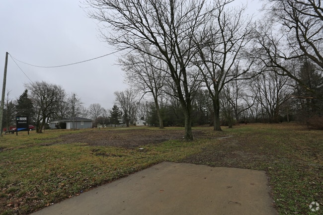
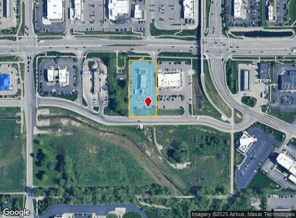
Property Record
819 E State Road 32, Westfield, IN 46074
NEARBY LISTINGS FOR SALE OR LEASE
Property Detail
819 E State Road 32
Indianapolis-Carmel-Greenwood, IN
Monon Crossing
29-09-01-101-005.000-015
ACREAGE 1.33, SECTION 1, TOWNSHIP 18, RANGE 3, MONON CROSSING, LOT 2, IRREGULAR SHAPE
Restaurantdrivein
Hamilton
X
Indiana
18057C0120G
2
2024
1.33 AC
2024
Far North Hamilton Cnty
110301
Indianapolis
3,283 SF
DEMOGRAPHICS near 819 E State Road 32
1 Mile
3 Mile
5 Mile
2024 Total Population
4,661
46,718
113,652
2029 Population
5,299
53,225
129,474
Pop Growth 2024-2029
+ 13.69%
+ 13.93%
+ 13.92%
Average Age
39
37
38
2024 Total Households
1,879
16,768
42,060
HH Growth 2024-2029
+ 13.41%
+ 13.88%
+ 13.97%
Median Household Inc
$81,861
$95,571
$103,206
Avg Household Size
2.50
2.80
2.70
2024 Avg HH Vehicles
2.00
2.00
2.00
Median Home Value
$246,465
$328,436
$355,609
Median Year Built
2002
2006
2004
Nearby Places
Map Layers
Map Styles
 Street
 Aerial
- Restaurants
- Banks
- Shops
- Fitness
- Groceries
PUBLIC TRANSPORTATION
AIRPORT
Indianapolis International
DRIVE
WALK
Distance
Indianapolis International
56 min
35.7 mi
Freight Ports
Port of Toledo
DRIVE
WALK
Distance
Port of Toledo
261 min
215.5 mi
SALE & LEASE HISTORY
LISTING DATE
SALE/LEASE

May 17, 2018
For Sale
Nearby Properties
Address
Land Use
TOTAL SIZE
Lot Size
Zoning
Address
Land Use
TOTAL SIZE
Lot Size
Zoning
27,385 SF
77.27 AC
Address
Land Use
TOTAL SIZE
Lot Size
Zoning
504,699 SF
40 AC
Address
Land Use
TOTAL SIZE
Lot Size
Zoning
383,016 SF
16.62 AC
Address
Land Use
TOTAL SIZE
Lot Size
Zoning
328,692 SF
12 AC
Address
Land Use
TOTAL SIZE
Lot Size
Zoning
388,202 SF
23.97 AC
Address
Land Use
TOTAL SIZE
Lot Size
Zoning
6.46 AC
Address
Land Use
TOTAL SIZE
Lot Size
Zoning
296,315 SF
17.65 AC
Address
Land Use
TOTAL SIZE
Lot Size
Zoning
97,726 SF
8.49 AC
Address
Land Use
TOTAL SIZE
Lot Size
Zoning
370,914 SF
14.30 AC
Address
Land Use
TOTAL SIZE
Lot Size
Zoning
145,444 SF
34.32 AC
Address
Land Use
TOTAL SIZE
Lot Size
Zoning
173,884 SF
14.07 AC
Address
Land Use
TOTAL SIZE
Lot Size
Zoning
203,619 SF
6.66 AC
Address
Land Use
TOTAL SIZE
Lot Size
Zoning
129,851 SF
42.03 AC
Address
Land Use
TOTAL SIZE
Lot Size
Zoning
281,397 SF
18.08 AC
Address
Land Use
TOTAL SIZE
Lot Size
Zoning
153,602 SF
50.17 AC
Address
Land Use
TOTAL SIZE
Lot Size
Zoning
141,255 SF
21.61 AC
Address
Land Use
TOTAL SIZE
Lot Size
Zoning
231,080 SF
9.28 AC
Address
Land Use
TOTAL SIZE
Lot Size
Zoning
73,680 SF
19.08 AC
Address
Land Use
TOTAL SIZE
Lot Size
Zoning
87,040 SF
24.23 AC
Address
Land Use
TOTAL SIZE
Lot Size
Zoning
314,499 SF
12 AC
Address
Land Use
TOTAL SIZE
Lot Size
Zoning
147,081 SF
56.70 AC
Address
Land Use
TOTAL SIZE
Lot Size
Zoning
290,862 SF
2.54 AC
Address
Land Use
TOTAL SIZE
Lot Size
Zoning
120,584 SF
20 AC
Address
Land Use
TOTAL SIZE
Lot Size
Zoning
129,005 SF
13.19 AC
Address
Land Use
TOTAL SIZE
Lot Size
Zoning
151,448 SF
10.58 AC
Address
Land Use
TOTAL SIZE
Lot Size
Zoning
110,412 SF
9.70 AC
Address
Land Use
TOTAL SIZE
Lot Size
Zoning
282,022 SF
7.65 AC
Address
Land Use
TOTAL SIZE
Lot Size
Zoning
149,213 SF
14.25 AC
Address
Land Use
TOTAL SIZE
Lot Size
Zoning
129,634 SF
12.71 AC
Address
Land Use
TOTAL SIZE
Lot Size
Zoning
183,536 SF
13.34 AC
The World's #1 Commercial Real Estate Marketplace
Connect with us
© 2026 CoStar Group
The information above has been obtained from sources believed reliable. While we do not doubt its accuracy we have not verified it and make no guarantee, warranty or representation about it. It is your responsibility to independently confirm its accuracy and completeness. Any projections, opinions, assumptions, or estimates used are for example only and do not represent the current or future performance of the property. The value of this transaction to you depends on tax and other factors which should be evaluated by your tax, financial, and legal advisors. You and your advisors should conduct a careful, independent investigation of the property to determine to your satisfaction the suitability of the property for your needs.