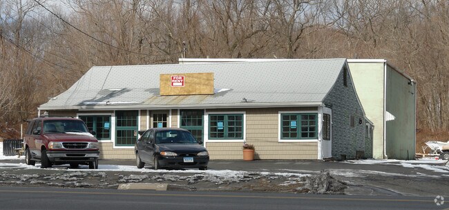
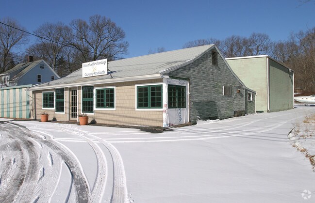
Property Record
819 Middle Tpke E, Manchester, CT 06040

Property Detail
819 Middle Tpke E
MANC-000136-003950-000819
Capitol
Commercialnec
Connecticut
AA
819
B and X Area of moderate flood hazard, usually the area between the limits of the 100-year and 500-year floods.
2.94 AC
2025
Manchester
2025
Hartford
510200
Hartford-West Hartford-East Hartford, CT
NEARBY LISTINGS FOR SALE OR LEASE
-
-
View all Manchester listings for sale on LoopNet.com
DEMOGRAPHICS near 819 Middle Tpke E
1 mile
3 mile
5 mile
2025 Total Population
4,918
47,909
99,910
2030 Population
5,018
48,666
101,887
Pop Growth 2025-2030
+ 2.03%
+ 1.58%
+ 1.98%
Average Age
44
41
41
2025 Total Households
1,993
20,033
41,735
HH Growth 2025-2030
+ 1.96%
+ 1.59%
+ 2.02%
Median Household Inc
$117,391
$88,901
$95,598
Avg Household Size
2.40
2.30
2.30
2025 Avg HH Vehicles
2.00
2.00
2.00
Median Home Value
$270,882
$267,184
$292,500
Median Year Built
1956
1958
1969
Nearby Places
Map Layers
Map Styles
 Street
 Aerial
Transit
 Traffic
 Biking
Places
Listings with unknown addresses are not visible on the map
- Restaurants
- Banks
- Shops
- Fitness
- Groceries
PUBLIC TRANSPORTATION
AIRPORT
Bradley International
Drive
Walk
Distance
Bradley International
42 min
23.2 mi
Freight Ports
Port of New Haven
Drive
Walk
Distance
Port of New Haven
63 min
48.4 mi
Nearby Properties
Address
Land Use
TOTAL SIZE
Lot Size
Zoning
Address
Land Use
TOTAL SIZE
Lot Size
Zoning
12.54 AC
Address
Land Use
TOTAL SIZE
Lot Size
Zoning
29,744 SF
29.50 AC
PRD
Address
Land Use
TOTAL SIZE
Lot Size
Zoning
24.02 AC
COMMER
Address
Land Use
TOTAL SIZE
Lot Size
Zoning
53.59 AC
RA
Address
Land Use
TOTAL SIZE
Lot Size
Zoning
219,479 SF
9.32 AC
H
Address
Land Use
TOTAL SIZE
Lot Size
Zoning
22.12 AC
FBZ
Address
Land Use
TOTAL SIZE
Lot Size
Zoning
68,988 SF
9.17 AC
GB
Address
Land Use
TOTAL SIZE
Lot Size
Zoning
6.38 AC
CBD
Address
Land Use
TOTAL SIZE
Lot Size
Zoning
79,198 SF
10.47 AC
RA
Address
Land Use
TOTAL SIZE
Lot Size
Zoning
195,772 SF
3.17 AC
H
Address
Land Use
TOTAL SIZE
Lot Size
Zoning
6.80 AC
H
Address
Land Use
TOTAL SIZE
Lot Size
Zoning
16 AC
RA
Address
Land Use
TOTAL SIZE
Lot Size
Zoning
19.72 AC
GB
Address
Land Use
TOTAL SIZE
Lot Size
Zoning
16.18 AC
COMMER
Address
Land Use
TOTAL SIZE
Lot Size
Zoning
116,406 SF
10.64 AC
RA
Address
Land Use
TOTAL SIZE
Lot Size
Zoning
54,012 SF
16.64 AC
RA
Address
Land Use
TOTAL SIZE
Lot Size
Zoning
16.23 AC
CUD
Address
Land Use
TOTAL SIZE
Lot Size
Zoning
6.76 AC
B5
Address
Land Use
TOTAL SIZE
Lot Size
Zoning
5.80 AC
SDC
Address
Land Use
TOTAL SIZE
Lot Size
Zoning
129,700 SF
3.60 AC
H
Address
Land Use
TOTAL SIZE
Lot Size
Zoning
17.55 AC
COMMER
Address
Land Use
TOTAL SIZE
Lot Size
Zoning
78,559 SF
25.70 AC
R-1
Address
Land Use
TOTAL SIZE
Lot Size
Zoning
119,542 SF
3.80 AC
RB/HIS
Address
Land Use
TOTAL SIZE
Lot Size
Zoning
3,732 SF
12.24 AC
RM
Address
Land Use
TOTAL SIZE
Lot Size
Zoning
12,480 SF
15.55 AC
RA
Address
Land Use
TOTAL SIZE
Lot Size
Zoning
92,400 SF
9.46 AC
CUD
Address
Land Use
TOTAL SIZE
Lot Size
Zoning
88,194 SF
11.82 AC
GB
Address
Land Use
TOTAL SIZE
Lot Size
Zoning
69,160 SF
7.65 AC
FBZ
Address
Land Use
TOTAL SIZE
Lot Size
Zoning
30,443 SF
2.59 AC
RB
Address
Land Use
TOTAL SIZE
Lot Size
Zoning
65,508 SF
8.93 AC
R-27
The World's #1 Commercial Real Estate Marketplace
Connect with us
© 2026 CoStar Group
The information above has been obtained from sources believed reliable. While we do not doubt its accuracy we have not verified it and make no guarantee, warranty or representation about it. It is your responsibility to independently confirm its accuracy and completeness. Any projections, opinions, assumptions, or estimates used are for example only and do not represent the current or future performance of the property. The value of this transaction to you depends on tax and other factors which should be evaluated by your tax, financial, and legal advisors. You and your advisors should conduct a careful, independent investigation of the property to determine to your satisfaction the suitability of the property for your needs.