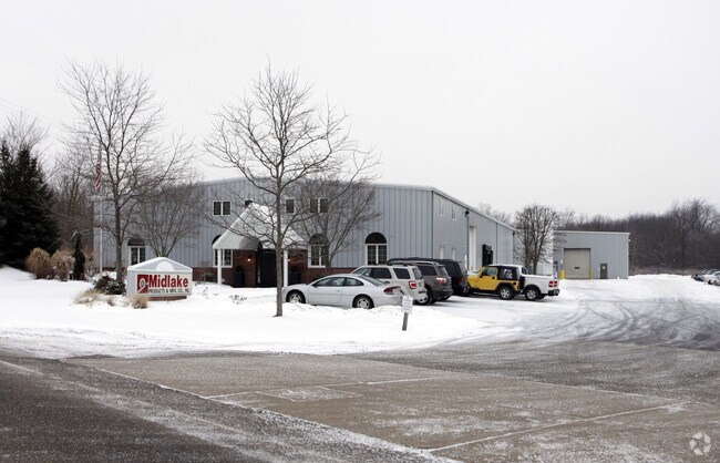
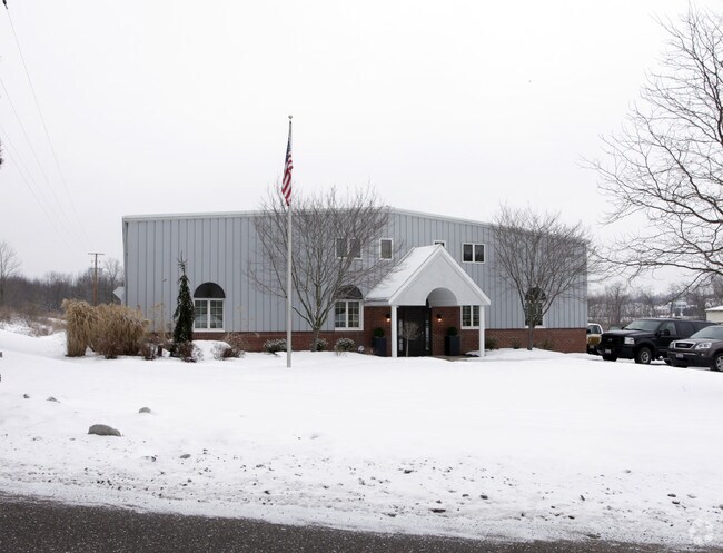
Property Record
819 N Nickelplate St, Louisville, OH 44641

NEARBY LISTINGS FOR SALE OR LEASE
-
-
View all Louisville listings for sale on LoopNet.com
Property Detail
819 N Nickelplate St
10002854
OL 374 (14.15A)
Lightindustrial
Stark
X
Ohio
39151C0253E
14.15 AC
0
Stark County
2025
Cleveland
712602
Canton-Massillon, OH
70,327 SF
DEMOGRAPHICS near 819 N Nickelplate St
1 Mile
3 Mile
5 Mile
2024 Total Population
6,254
17,363
39,028
2029 Population
6,187
17,160
38,731
Pop Growth 2024-2029
(1.07%)
(1.17%)
(0.76%)
Average Age
41
42
42
2024 Total Households
2,649
7,093
15,917
HH Growth 2024-2029
(1.13%)
(1.21%)
(0.80%)
Median Household Inc
$63,546
$71,160
$61,538
Avg Household Size
2.30
2.40
2.40
2024 Avg HH Vehicles
2.00
2.00
2.00
Median Home Value
$163,736
$171,342
$159,021
Median Year Built
1965
1969
1966
Nearby Places
Map Layers
Map Styles
 Street
 Aerial
- Restaurants
- Banks
- Shops
- Fitness
- Groceries
PUBLIC TRANSPORTATION
AIRPORT
Akron-Canton Regional
DRIVE
WALK
Distance
Akron-Canton Regional
26 min
16.7 mi
Freight Ports
Port of Toledo
DRIVE
WALK
Distance
Port of Toledo
197 min
164.0 mi
Nearby Properties
Address
Land Use
TOTAL SIZE
Lot Size
Zoning
Address
Land Use
TOTAL SIZE
Lot Size
Zoning
125,619 SF
13.15 AC
Address
Land Use
TOTAL SIZE
Lot Size
Zoning
141,077 SF
21.73 AC
Address
Land Use
TOTAL SIZE
Lot Size
Zoning
109,663 SF
4.26 AC
Address
Land Use
TOTAL SIZE
Lot Size
Zoning
681,718 SF
35.20 AC
Address
Land Use
TOTAL SIZE
Lot Size
Zoning
202,684 SF
40.97 AC
Address
Land Use
TOTAL SIZE
Lot Size
Zoning
133,991 SF
24.51 AC
Address
Land Use
TOTAL SIZE
Lot Size
Zoning
153,834 SF
20.21 AC
Address
Land Use
TOTAL SIZE
Lot Size
Zoning
81,369 SF
3 AC
Address
Land Use
TOTAL SIZE
Lot Size
Zoning
124,064 SF
3.52 AC
Address
Land Use
TOTAL SIZE
Lot Size
Zoning
172,485 SF
13.35 AC
Address
Land Use
TOTAL SIZE
Lot Size
Zoning
132,981 SF
34.70 AC
Address
Land Use
TOTAL SIZE
Lot Size
Zoning
51,131 SF
9.73 AC
Address
Land Use
TOTAL SIZE
Lot Size
Zoning
187,797 SF
20.29 AC
Address
Land Use
TOTAL SIZE
Lot Size
Zoning
14,070 SF
10.04 AC
Address
Land Use
TOTAL SIZE
Lot Size
Zoning
190,075 SF
37.87 AC
Address
Land Use
TOTAL SIZE
Lot Size
Zoning
49,900 SF
1.31 AC
Address
Land Use
TOTAL SIZE
Lot Size
Zoning
54,593 SF
10.66 AC
Address
Land Use
TOTAL SIZE
Lot Size
Zoning
52,324 SF
8.52 AC
Address
Land Use
TOTAL SIZE
Lot Size
Zoning
11,179 SF
79.99 AC
Address
Land Use
TOTAL SIZE
Lot Size
Zoning
28,777 SF
3.24 AC
Address
Land Use
TOTAL SIZE
Lot Size
Zoning
86,331 SF
3.67 AC
Address
Land Use
TOTAL SIZE
Lot Size
Zoning
106,719 SF
16.09 AC
Address
Land Use
TOTAL SIZE
Lot Size
Zoning
8,744 SF
234.79 AC
Address
Land Use
TOTAL SIZE
Lot Size
Zoning
46,104 SF
5.40 AC
Address
Land Use
TOTAL SIZE
Lot Size
Zoning
5,536 SF
4.21 AC
Address
Land Use
TOTAL SIZE
Lot Size
Zoning
96,000 SF
8.38 AC
Address
Land Use
TOTAL SIZE
Lot Size
Zoning
32,102 SF
0.42 AC
Address
Land Use
TOTAL SIZE
Lot Size
Zoning
46,620 SF
13 AC
Address
Land Use
TOTAL SIZE
Lot Size
Zoning
220,600 SF
16.74 AC
The World's #1 Commercial Real Estate Marketplace
Connect with us
© 2026 CoStar Group
The information above has been obtained from sources believed reliable. While we do not doubt its accuracy we have not verified it and make no guarantee, warranty or representation about it. It is your responsibility to independently confirm its accuracy and completeness. Any projections, opinions, assumptions, or estimates used are for example only and do not represent the current or future performance of the property. The value of this transaction to you depends on tax and other factors which should be evaluated by your tax, financial, and legal advisors. You and your advisors should conduct a careful, independent investigation of the property to determine to your satisfaction the suitability of the property for your needs.