Property Record
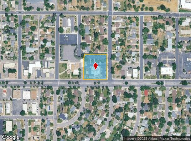
819 W Littleton Blvd, Littleton, CO 80120

NEARBY LISTINGS FOR SALE OR LEASE
Property Detail
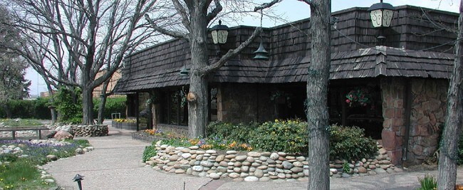
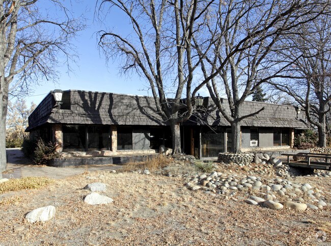
819 W Littleton Blvd
Denver-Aurora-Lakewood, CO
Stark Bros Woodlawn Add 2Nd Flg
2077-16-4-15-003
PORTION LOT3
Restaurantbuilding
Arapahoe
X
Colorado
08005C0451M
3
2023
1.22 AC
2024
South
006601
Denver
9,115 SF
DEMOGRAPHICS near 819 W Littleton Blvd
1 Mile
3 Mile
5 Mile
2024 Total Population
17,730
93,767
278,652
2029 Population
17,933
94,064
283,399
Pop Growth 2024-2029
+ 1.14%
+ 0.32%
+ 1.70%
Average Age
39
42
42
2024 Total Households
8,076
40,187
116,222
HH Growth 2024-2029
+ 1.21%
+ 0.35%
+ 1.87%
Median Household Inc
$57,795
$87,213
$97,384
Avg Household Size
2.10
2.30
2.30
2024 Avg HH Vehicles
2.00
2.00
2.00
Median Home Value
$498,402
$566,137
$616,728
Median Year Built
1967
1972
1977
Nearby Places
Map Layers
Map Styles
 Street
 Aerial
- Restaurants
- Banks
- Shops
- Fitness
- Groceries
PUBLIC TRANSPORTATION
TRANSIT/SUBWAY
Littletown-Downtown (C Line - Denver Regional Transportation District Light Rail (TheRide), D Line - Denver Regional Transportation District Light Rail (TheRide))
DRIVE
WALK
Distance
Littletown-Downtown (C Line - Denver Regional Transportation District Light Rail (TheRide), D Line - Denver Regional Transportation District Light Rail (TheRide))
3 min
20 min
1.1 mi
AIRPORT
Denver International
DRIVE
WALK
Distance
Denver International
43 min
32.0 mi
Freight Ports
Tulsa Port Of Catoosa
DRIVE
WALK
Distance
Tulsa Port Of Catoosa
739 min
714.7 mi
SALE & LEASE HISTORY
LISTING DATE
SALE/LEASE

Sep 12, 2019
For Sale
Apr 04, 2018
For Lease
Nearby Properties
Address
Land Use
TOTAL SIZE
Lot Size
Zoning
Address
Land Use
TOTAL SIZE
Lot Size
Zoning
390,078 SF
38.27 AC
Address
Land Use
TOTAL SIZE
Lot Size
Zoning
248,291 SF
128.77 AC
CMP-H2
Address
Land Use
TOTAL SIZE
Lot Size
Zoning
330,776 SF
48.11 AC
CMP-H2
Address
Land Use
TOTAL SIZE
Lot Size
Zoning
214,192 SF
0.03 AC
Address
Land Use
TOTAL SIZE
Lot Size
Zoning
251,583 SF
38.03 AC
Address
Land Use
TOTAL SIZE
Lot Size
Zoning
133,908 SF
9.39 AC
LPD-C
Address
Land Use
TOTAL SIZE
Lot Size
Zoning
167,287 SF
13.65 AC
Address
Land Use
TOTAL SIZE
Lot Size
Zoning
177,772 SF
16 AC
Address
Land Use
TOTAL SIZE
Lot Size
Zoning
572,657 SF
0.21 AC
LPD-C
Address
Land Use
TOTAL SIZE
Lot Size
Zoning
411,924 SF
26.85 AC
LPDI
Address
Land Use
TOTAL SIZE
Lot Size
Zoning
221,025 SF
8.45 AC
PUD
Address
Land Use
TOTAL SIZE
Lot Size
Zoning
192,108 SF
20.03 AC
Address
Land Use
TOTAL SIZE
Lot Size
Zoning
118,881 SF
107.83 AC
Address
Land Use
TOTAL SIZE
Lot Size
Zoning
107,159 SF
26.40 AC
Address
Land Use
TOTAL SIZE
Lot Size
Zoning
47.24 AC
Address
Land Use
TOTAL SIZE
Lot Size
Zoning
7,035 SF
12.90 AC
LPD-R
Address
Land Use
TOTAL SIZE
Lot Size
Zoning
110,016 SF
1.29 AC
Address
Land Use
TOTAL SIZE
Lot Size
Zoning
250,402 SF
21 AC
Address
Land Use
TOTAL SIZE
Lot Size
Zoning
206,632 SF
33.68 AC
Address
Land Use
TOTAL SIZE
Lot Size
Zoning
61,607 SF
11.60 AC
LPD-C
Address
Land Use
TOTAL SIZE
Lot Size
Zoning
39.44 AC
Address
Land Use
TOTAL SIZE
Lot Size
Zoning
157,145 SF
15.70 AC
Address
Land Use
TOTAL SIZE
Lot Size
Zoning
133,594 SF
25.03 AC
Address
Land Use
TOTAL SIZE
Lot Size
Zoning
146,156 SF
4.61 AC
Address
Land Use
TOTAL SIZE
Lot Size
Zoning
351,792 SF
16.99 AC
LPD-C
Address
Land Use
TOTAL SIZE
Lot Size
Zoning
248,058 SF
12.24 AC
Address
Land Use
TOTAL SIZE
Lot Size
Zoning
677,688 SF
2.97 AC
Address
Land Use
TOTAL SIZE
Lot Size
Zoning
255,868 SF
35.96 AC
Address
Land Use
TOTAL SIZE
Lot Size
Zoning
146,877 SF
11.52 AC
Address
Land Use
TOTAL SIZE
Lot Size
Zoning
280,912 SF
10.98 AC
The World's #1 Commercial Real Estate Marketplace
Connect with us
© 2025 CoStar Group
The information above has been obtained from sources believed reliable. While we do not doubt its accuracy we have not verified it and make no guarantee, warranty or representation about it. It is your responsibility to independently confirm its accuracy and completeness. Any projections, opinions, assumptions, or estimates used are for example only and do not represent the current or future performance of the property. The value of this transaction to you depends on tax and other factors which should be evaluated by your tax, financial, and legal advisors. You and your advisors should conduct a careful, independent investigation of the property to determine to your satisfaction the suitability of the property for your needs.