Property Record
8190 N Main St, Baytown, TX 77521

This Property Is For Sale
Property Detail
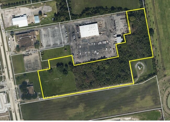
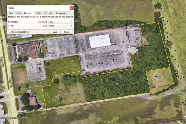
8190 N Main St
0402210000137
TR 8C ABST 21 G ELLIS
Telephonefacility
HARRIS
B and X Area of moderate flood hazard, usually the area between the limits of the 100-year and 500-year floods.
Texas
2025
14.65 AC
2025
Northeast Outlier
253202
Houston
24,240 SF
Houston-Pasadena-The Woodlands, TX
NEARBY LISTINGS FOR SALE OR LEASE
DEMOGRAPHICS near 8190 N Main St
1 mile
3 mile
5 mile
2025 Total Population
4,188
23,685
91,986
2030 Population
4,531
25,781
100,223
Pop Growth 2025-2030
+ 8.19%
+ 8.85%
+ 8.95%
Average Age
33
35
36
2025 Total Households
1,159
7,449
31,257
HH Growth 2025-2030
+ 8.37%
+ 8.81%
+ 8.94%
Median Household Inc
$95,476
$92,105
$75,797
Avg Household Size
3.60
3.10
2.90
2025 Avg HH Vehicles
3.00
2.00
2.00
Median Home Value
$260,217
$283,897
$248,985
Median Year Built
2010
2006
1999
Nearby Places
Map Layers
Map Styles
 Street
 Aerial
Layers
 Traffic
 Biking
Places
Listings with unknown addresses are not visible on the map
- Restaurants
- Banks
- Shops
- Fitness
- Groceries
PUBLIC TRANSPORTATION
AIRPORT
William P Hobby
Drive
Walk
Distance
William P Hobby
47 min
31.5 mi
George Bush Intcntl/Houston
Drive
Walk
Distance
George Bush Intcntl/Houston
44 min
35.7 mi
Freight Ports
Port of Houston
Drive
Walk
Distance
Port of Houston
34 min
23.5 mi
Nearby Properties
Address
Land Use
TOTAL SIZE
Lot Size
Zoning
Address
Land Use
TOTAL SIZE
Lot Size
Zoning
0.58 AC
Address
Land Use
TOTAL SIZE
Lot Size
Zoning
63,224 SF
738.31 AC
Address
Land Use
TOTAL SIZE
Lot Size
Zoning
738.47 AC
Address
Land Use
TOTAL SIZE
Lot Size
Zoning
463.62 AC
Address
Land Use
TOTAL SIZE
Lot Size
Zoning
738.31 AC
Address
Land Use
TOTAL SIZE
Lot Size
Zoning
Address
Land Use
TOTAL SIZE
Lot Size
Zoning
Address
Land Use
TOTAL SIZE
Lot Size
Zoning
738.47 AC
Address
Land Use
TOTAL SIZE
Lot Size
Zoning
504,680 SF
29.61 AC
Address
Land Use
TOTAL SIZE
Lot Size
Zoning
291,462 SF
13.43 AC
Address
Land Use
TOTAL SIZE
Lot Size
Zoning
352,067 SF
19.78 AC
Address
Land Use
TOTAL SIZE
Lot Size
Zoning
284,794 SF
10.18 AC
Address
Land Use
TOTAL SIZE
Lot Size
Zoning
251,498 SF
16.36 AC
Address
Land Use
TOTAL SIZE
Lot Size
Zoning
103.45 AC
Address
Land Use
TOTAL SIZE
Lot Size
Zoning
59.21 AC
Address
Land Use
TOTAL SIZE
Lot Size
Zoning
122,554 SF
12.85 AC
Address
Land Use
TOTAL SIZE
Lot Size
Zoning
71,560 SF
17.89 AC
Address
Land Use
TOTAL SIZE
Lot Size
Zoning
738.47 AC
Address
Land Use
TOTAL SIZE
Lot Size
Zoning
103,107 SF
15.56 AC
Address
Land Use
TOTAL SIZE
Lot Size
Zoning
956.90 AC
Address
Land Use
TOTAL SIZE
Lot Size
Zoning
69,976 SF
7.37 AC
Address
Land Use
TOTAL SIZE
Lot Size
Zoning
138,240 SF
2.95 AC
Address
Land Use
TOTAL SIZE
Lot Size
Zoning
94,350 SF
8 AC
Address
Land Use
TOTAL SIZE
Lot Size
Zoning
224,472 SF
12 AC
Address
Land Use
TOTAL SIZE
Lot Size
Zoning
83,772 SF
8.09 AC
Address
Land Use
TOTAL SIZE
Lot Size
Zoning
39,869 SF
7.97 AC
Address
Land Use
TOTAL SIZE
Lot Size
Zoning
44,652 SF
12.33 AC
Address
Land Use
TOTAL SIZE
Lot Size
Zoning
79,777 SF
3.96 AC
Address
Land Use
TOTAL SIZE
Lot Size
Zoning
139,880 SF
2.97 AC
Address
Land Use
TOTAL SIZE
Lot Size
Zoning
247,604 SF
24.17 AC
The World's #1 Commercial Real Estate Marketplace
Connect with us
© 2026 CoStar Group
The information above has been obtained from sources believed reliable. While we do not doubt its accuracy we have not verified it and make no guarantee, warranty or representation about it. It is your responsibility to independently confirm its accuracy and completeness. Any projections, opinions, assumptions, or estimates used are for example only and do not represent the current or future performance of the property. The value of this transaction to you depends on tax and other factors which should be evaluated by your tax, financial, and legal advisors. You and your advisors should conduct a careful, independent investigation of the property to determine to your satisfaction the suitability of the property for your needs.