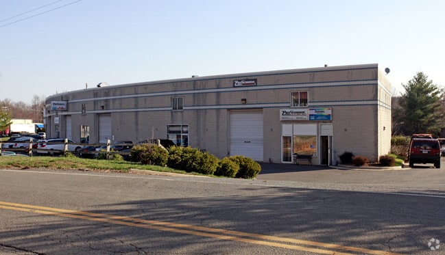
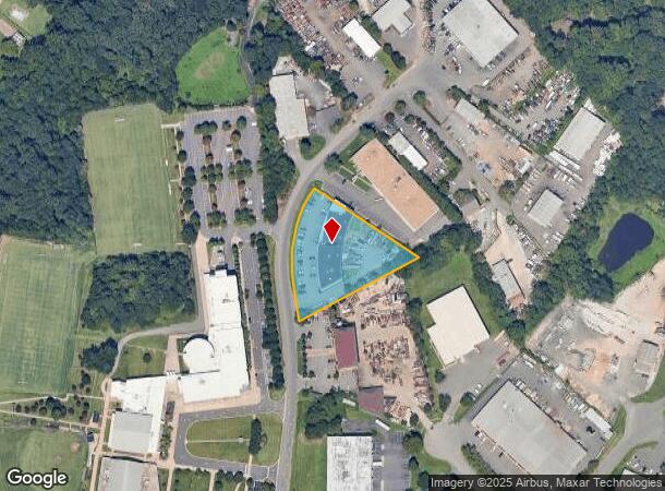
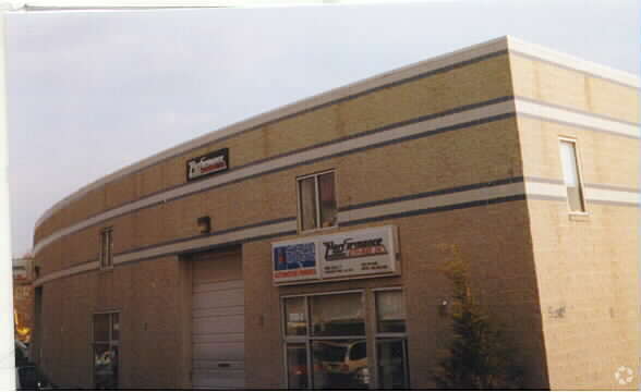
Property Record
8199 Euclid Ct, Manassas Park, VA 20111

NEARBY LISTINGS FOR SALE OR LEASE
Property Detail
8199 Euclid Ct
Washington-Arlington-Alexandria, DC-VA-MD-WV
Conner Center
11-2-64
LOT 64 PHASE 3 CONNER CENTER LT 1.5781 AC
Industrialgeneral
Manassas Park
X
Virginia
51059C0240E
64
2023
1.57 AC
2025
Manassas
920201
Washington, DC
DEMOGRAPHICS near 8199 Euclid Ct
1 Mile
3 Mile
5 Mile
2024 Total Population
9,108
76,892
200,915
2029 Population
9,041
76,502
200,614
Pop Growth 2024-2029
(0.74%)
(0.51%)
(0.15%)
Average Age
35
37
37
2024 Total Households
2,978
23,835
65,055
HH Growth 2024-2029
(0.97%)
(0.60%)
(0.24%)
Median Household Inc
$80,584
$111,122
$112,011
Avg Household Size
3.00
3.10
3.00
2024 Avg HH Vehicles
2.00
2.00
2.00
Median Home Value
$399,458
$421,929
$440,114
Median Year Built
1991
1985
1987
Nearby Places
Map Layers
Map Styles
 Street
 Aerial
- Restaurants
- Banks
- Shops
- Fitness
- Groceries
PUBLIC TRANSPORTATION
COMMUTER RAIL
Manassas Park (Manassas Line - Virginia Railway Express)
DRIVE
WALK
Distance
Manassas Park (Manassas Line - Virginia Railway Express)
6 min
1.7 mi
Manassas (Manassas Line - Virginia Railway Express)
DRIVE
WALK
Distance
Manassas (Manassas Line - Virginia Railway Express)
9 min
3.1 mi
AIRPORT
Washington Dulles International
DRIVE
WALK
Distance
Washington Dulles International
33 min
17.7 mi
Ronald Reagan Washington Ntl
DRIVE
WALK
Distance
Ronald Reagan Washington Ntl
49 min
32.3 mi
Nearby Properties
Address
Land Use
TOTAL SIZE
Lot Size
Zoning
Address
Land Use
TOTAL SIZE
Lot Size
Zoning
328,915 SF
117.39 AC
030
Address
Land Use
TOTAL SIZE
Lot Size
Zoning
382,368 SF
18.40 AC
PMR
Address
Land Use
TOTAL SIZE
Lot Size
Zoning
402,295 SF
8.50 AC
A1
Address
Land Use
TOTAL SIZE
Lot Size
Zoning
23.93 AC
PUD
Address
Land Use
TOTAL SIZE
Lot Size
Zoning
203,544 SF
20.90 AC
GENERAL CO
Address
Land Use
TOTAL SIZE
Lot Size
Zoning
529,436 SF
24.63 AC
MIXED
Address
Land Use
TOTAL SIZE
Lot Size
Zoning
10.62 AC
PUD
Address
Land Use
TOTAL SIZE
Lot Size
Zoning
18,128 SF
MULTI-FAMI
Address
Land Use
TOTAL SIZE
Lot Size
Zoning
349,608 SF
60.83 AC
A1
Address
Land Use
TOTAL SIZE
Lot Size
Zoning
31,032 SF
15.29 AC
MULTI-FAMI
Address
Land Use
TOTAL SIZE
Lot Size
Zoning
3.49 AC
MU-D
Address
Land Use
TOTAL SIZE
Lot Size
Zoning
205,000 SF
37.08 AC
LOW DENSIT
Address
Land Use
TOTAL SIZE
Lot Size
Zoning
3.41 AC
MU-D
Address
Land Use
TOTAL SIZE
Lot Size
Zoning
140,188 SF
12.76 AC
CITY CENTE
Address
Land Use
TOTAL SIZE
Lot Size
Zoning
325,000 SF
27.97 AC
SMALL LOTS
Address
Land Use
TOTAL SIZE
Lot Size
Zoning
45,585 SF
17.95 AC
GENERAL CO
Address
Land Use
TOTAL SIZE
Lot Size
Zoning
74,450 SF
2.91 AC
CITY CENTE
Address
Land Use
TOTAL SIZE
Lot Size
Zoning
159,940 SF
30 AC
R4
Address
Land Use
TOTAL SIZE
Lot Size
Zoning
71,303 SF
0.54 AC
GENERAL CO
Address
Land Use
TOTAL SIZE
Lot Size
Zoning
8,562 SF
13.50 AC
MULTI-FAMI
Address
Land Use
TOTAL SIZE
Lot Size
Zoning
149,911 SF
13.15 AC
MULTI-FAMI
Address
Land Use
TOTAL SIZE
Lot Size
Zoning
54,401 SF
8.56 AC
PLANNED MI
Address
Land Use
TOTAL SIZE
Lot Size
Zoning
178,423 SF
81.57 AC
030
Address
Land Use
TOTAL SIZE
Lot Size
Zoning
150,000 SF
3.50 AC
CITY CENTE
Address
Land Use
TOTAL SIZE
Lot Size
Zoning
3.43 AC
MU-D
Address
Land Use
TOTAL SIZE
Lot Size
Zoning
106,768 SF
13.28 AC
R4
Address
Land Use
TOTAL SIZE
Lot Size
Zoning
94,305 SF
0.77 AC
CITY CENTE
Address
Land Use
TOTAL SIZE
Lot Size
Zoning
25,228 SF
9.26 AC
R16
Address
Land Use
TOTAL SIZE
Lot Size
Zoning
36,627 SF
LIGHT INDU
Address
Land Use
TOTAL SIZE
Lot Size
Zoning
75,688 SF
2.59 AC
A1
The World's #1 Commercial Real Estate Marketplace
Connect with us
© 2025 CoStar Group
The information above has been obtained from sources believed reliable. While we do not doubt its accuracy we have not verified it and make no guarantee, warranty or representation about it. It is your responsibility to independently confirm its accuracy and completeness. Any projections, opinions, assumptions, or estimates used are for example only and do not represent the current or future performance of the property. The value of this transaction to you depends on tax and other factors which should be evaluated by your tax, financial, and legal advisors. You and your advisors should conduct a careful, independent investigation of the property to determine to your satisfaction the suitability of the property for your needs.