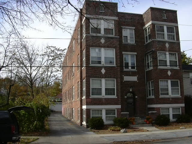
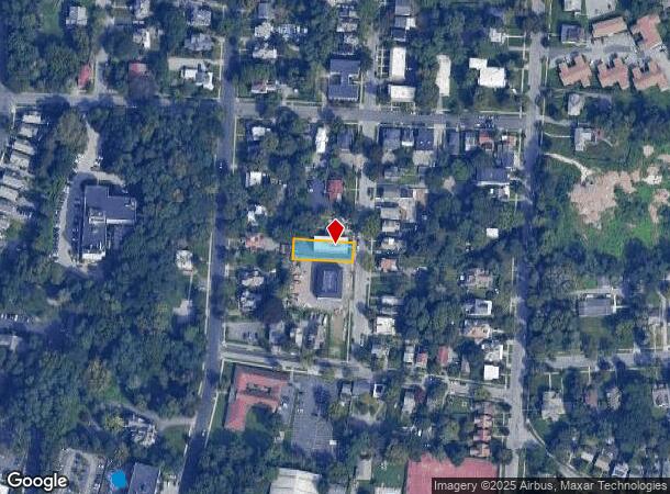
Property Record
82 Carroll St, Poughkeepsie, NY 12601
NEARBY LISTINGS FOR SALE OR LEASE
Property Detail
82 Carroll St
Dutchess County-Putnam County, NY
French Place
131300-6161-29-071774-0000
50 X 160 22000 02185 2019 0154
Apartment
Dutchess
X
New York
36027C0358E
71
2025
0.18 AC
2024
Poughkeepsie
220801
Westchester/So Connecticut
11,440 SF
DEMOGRAPHICS near 82 Carroll St
1 Mile
3 Mile
5 Mile
2024 Total Population
21,039
64,563
99,029
2029 Population
20,954
64,636
99,126
Pop Growth 2024-2029
(0.40%)
+ 0.11%
+ 0.10%
Average Age
40
39
40
2024 Total Households
8,863
24,824
36,966
HH Growth 2024-2029
(0.26%)
+ 0.23%
+ 0.17%
Median Household Inc
$44,946
$61,944
$74,753
Avg Household Size
2.20
2.30
2.40
2024 Avg HH Vehicles
1.00
1.00
2.00
Median Home Value
$247,278
$263,177
$293,824
Median Year Built
1949
1962
1965
Nearby Places
- Restaurants
- Banks
- Shops
- Fitness
- Groceries
PUBLIC TRANSPORTATION
COMMUTER RAIL
Poughkeepsie Station (Hudson Line - Metro-North Commuter Railroad Company (Metro-North))
DRIVE
WALK
Distance
Poughkeepsie Station (Hudson Line - Metro-North Commuter Railroad Company (Metro-North))
4 min
1.5 mi
New Hamburg Station (Hudson Line - Metro-North Commuter Railroad Company (Metro-North))
DRIVE
WALK
Distance
New Hamburg Station (Hudson Line - Metro-North Commuter Railroad Company (Metro-North))
17 min
8.6 mi
AIRPORT
New York Stewart International
DRIVE
WALK
Distance
New York Stewart International
38 min
24.6 mi
Freight Ports
Port of New Haven
DRIVE
WALK
Distance
Port of New Haven
109 min
79.7 mi
SALE & LEASE HISTORY
LISTING DATE
SALE/LEASE

Jun 06, 2018
For Sale
Nearby Properties
Address
Land Use
TOTAL SIZE
Lot Size
Zoning
Address
Land Use
TOTAL SIZE
Lot Size
Zoning
640,854 SF
21.22 AC
H-M
Address
Land Use
TOTAL SIZE
Lot Size
Zoning
1,279,884 SF
255.89 AC
IN
Address
Land Use
TOTAL SIZE
Lot Size
Zoning
193.80 AC
IH
Address
Land Use
TOTAL SIZE
Lot Size
Zoning
539,228 SF
62.57 AC
IN
Address
Land Use
TOTAL SIZE
Lot Size
Zoning
314,927 SF
24.59 AC
IN
Address
Land Use
TOTAL SIZE
Lot Size
Zoning
4.99 AC
R2A
Address
Land Use
TOTAL SIZE
Lot Size
Zoning
488,904 SF
12.90 AC
R-3
Address
Land Use
TOTAL SIZE
Lot Size
Zoning
246,913 SF
43.93 AC
IN
Address
Land Use
TOTAL SIZE
Lot Size
Zoning
181,295 SF
20.48 AC
IN
Address
Land Use
TOTAL SIZE
Lot Size
Zoning
127,976 SF
6.57 AC
OR
Address
Land Use
TOTAL SIZE
Lot Size
Zoning
3 AC
R-D
Address
Land Use
TOTAL SIZE
Lot Size
Zoning
2.11 AC
IN
Address
Land Use
TOTAL SIZE
Lot Size
Zoning
4.49 AC
IH
Address
Land Use
TOTAL SIZE
Lot Size
Zoning
11,803 SF
99.04 AC
IH
Address
Land Use
TOTAL SIZE
Lot Size
Zoning
39.21 AC
R-1
Address
Land Use
TOTAL SIZE
Lot Size
Zoning
108,096 SF
2.50 AC
C-2
Address
Land Use
TOTAL SIZE
Lot Size
Zoning
105,762 SF
2.41 AC
H-M
Address
Land Use
TOTAL SIZE
Lot Size
Zoning
12,638 SF
159.73 AC
R2A
Address
Land Use
TOTAL SIZE
Lot Size
Zoning
5.29 AC
I-2
Address
Land Use
TOTAL SIZE
Lot Size
Zoning
4 AC
R-1
Address
Land Use
TOTAL SIZE
Lot Size
Zoning
296,400 SF
0.66 AC
C-2
Address
Land Use
TOTAL SIZE
Lot Size
Zoning
218,118 SF
13.15 AC
FC
Address
Land Use
TOTAL SIZE
Lot Size
Zoning
179,351 SF
18.34 AC
IN
Address
Land Use
TOTAL SIZE
Lot Size
Zoning
102,798 SF
16.71 AC
IN
Address
Land Use
TOTAL SIZE
Lot Size
Zoning
167,456 SF
18.50 AC
RM
Address
Land Use
TOTAL SIZE
Lot Size
Zoning
119,832 SF
18.20 AC
RM
Address
Land Use
TOTAL SIZE
Lot Size
Zoning
2.53 AC
R-D
Address
Land Use
TOTAL SIZE
Lot Size
Zoning
23,044 SF
12.60 AC
R-5
Address
Land Use
TOTAL SIZE
Lot Size
Zoning
103,108 SF
24.31 AC
HRDD
Address
Land Use
TOTAL SIZE
Lot Size
Zoning
126,616 SF
25.57 AC
R20
The World's #1 Commercial Real Estate Marketplace
Connect with us
© 2025 CoStar Group
The information above has been obtained from sources believed reliable. While we do not doubt its accuracy we have not verified it and make no guarantee, warranty or representation about it. It is your responsibility to independently confirm its accuracy and completeness. Any projections, opinions, assumptions, or estimates used are for example only and do not represent the current or future performance of the property. The value of this transaction to you depends on tax and other factors which should be evaluated by your tax, financial, and legal advisors. You and your advisors should conduct a careful, independent investigation of the property to determine to your satisfaction the suitability of the property for your needs.