Property Record
82 Craig St Reeds Spg, Reeds Spring, MO 65737

NEARBY LISTINGS FOR SALE OR LEASE
Property Detail
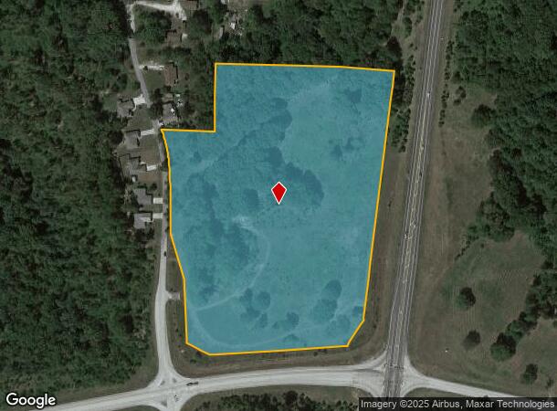
82 Craig St Reeds Spg
08-7.0-36-000-000-005.004
A PART OF THE SW LYING W OF THE HWY 413 & 150 ON THE E SIDE
Agriculturalland
Stone
X
Missouri
29209C0182D
16.40 AC
2024
Branson
2025
Other Market Areas
090605
Branson, MO
DEMOGRAPHICS near 82 Craig St Reeds Spg
1 Mile
3 Mile
5 Mile
2024 Total Population
947
2,543
5,763
2029 Population
1,009
2,719
6,238
Pop Growth 2024-2029
+ 6.55%
+ 6.92%
+ 8.24%
Average Age
42
43
45
2024 Total Households
374
1,003
2,342
HH Growth 2024-2029
+ 5.61%
+ 6.08%
+ 7.77%
Median Household Inc
$37,314
$41,154
$53,357
Avg Household Size
2.50
2.50
2.40
2024 Avg HH Vehicles
2.00
2.00
2.00
Median Home Value
$140,000
$156,374
$193,911
Median Year Built
1989
1990
1995
Nearby Places
Map Layers
Map Styles
 Street
 Aerial
- Restaurants
- Banks
- Shops
- Fitness
- Groceries
SALE & LEASE HISTORY
LISTING DATE
SALE/LEASE

Sep 24, 2016
For Sale
Nearby Properties
Address
Land Use
TOTAL SIZE
Lot Size
Zoning
Address
Land Use
TOTAL SIZE
Lot Size
Zoning
108,452 SF
47.84 AC
A-1
Address
Land Use
TOTAL SIZE
Lot Size
Zoning
153,535 SF
18.72 AC
NA
Address
Land Use
TOTAL SIZE
Lot Size
Zoning
6,000 SF
11.93 AC
NA
Address
Land Use
TOTAL SIZE
Lot Size
Zoning
44,979 SF
12.80 AC
NA
Address
Land Use
TOTAL SIZE
Lot Size
Zoning
74,763 SF
28.27 AC
NA
Address
Land Use
TOTAL SIZE
Lot Size
Zoning
14,748 SF
1.60 AC
NA
Address
Land Use
TOTAL SIZE
Lot Size
Zoning
15,000 SF
2.32 AC
NA
Address
Land Use
TOTAL SIZE
Lot Size
Zoning
93,998 SF
39 AC
NA
Address
Land Use
TOTAL SIZE
Lot Size
Zoning
23,640 SF
29.64 AC
NA
Address
Land Use
TOTAL SIZE
Lot Size
Zoning
25,052 SF
3.98 AC
NA
Address
Land Use
TOTAL SIZE
Lot Size
Zoning
36,558 SF
7.60 AC
NA
Address
Land Use
TOTAL SIZE
Lot Size
Zoning
8,100 SF
1.13 AC
Address
Land Use
TOTAL SIZE
Lot Size
Zoning
9,064 SF
1.40 AC
RR-1
Address
Land Use
TOTAL SIZE
Lot Size
Zoning
3,520 SF
1.30 AC
Address
Land Use
TOTAL SIZE
Lot Size
Zoning
5,932 SF
1.87 AC
NA
Address
Land Use
TOTAL SIZE
Lot Size
Zoning
4,403 SF
2.07 AC
NA
Address
Land Use
TOTAL SIZE
Lot Size
Zoning
8,964 SF
1.76 AC
NA
Address
Land Use
TOTAL SIZE
Lot Size
Zoning
6,625 SF
3.83 AC
NA
Address
Land Use
TOTAL SIZE
Lot Size
Zoning
15,039 SF
2 AC
NA
Address
Land Use
TOTAL SIZE
Lot Size
Zoning
9,974 SF
1.05 AC
NA
Address
Land Use
TOTAL SIZE
Lot Size
Zoning
18,100 SF
1.48 AC
NA
Address
Land Use
TOTAL SIZE
Lot Size
Zoning
12,338 SF
7.81 AC
C-2
Address
Land Use
TOTAL SIZE
Lot Size
Zoning
9,000 SF
1.80 AC
NA
Address
Land Use
TOTAL SIZE
Lot Size
Zoning
3,243 SF
6.80 AC
NA
Address
Land Use
TOTAL SIZE
Lot Size
Zoning
6,634 SF
24.06 AC
NA
Address
Land Use
TOTAL SIZE
Lot Size
Zoning
3,605 SF
1.19 AC
NA
Address
Land Use
TOTAL SIZE
Lot Size
Zoning
43,104 SF
5.86 AC
C-2
The World's #1 Commercial Real Estate Marketplace
Connect with us
© 2025 CoStar Group
The information above has been obtained from sources believed reliable. While we do not doubt its accuracy we have not verified it and make no guarantee, warranty or representation about it. It is your responsibility to independently confirm its accuracy and completeness. Any projections, opinions, assumptions, or estimates used are for example only and do not represent the current or future performance of the property. The value of this transaction to you depends on tax and other factors which should be evaluated by your tax, financial, and legal advisors. You and your advisors should conduct a careful, independent investigation of the property to determine to your satisfaction the suitability of the property for your needs.