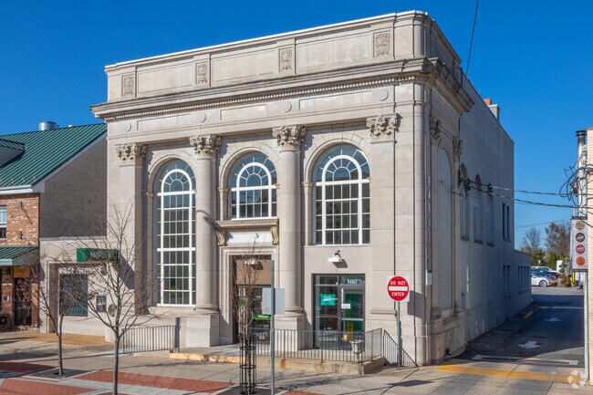
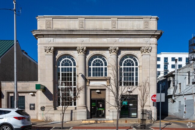
Property Record
82 E Main St, Newark, DE 19711

Property Detail
82 E Main St
18-020.00-031
New Castle
Financialbuilding
Delaware
18BB
7
B and X Area of moderate flood hazard, usually the area between the limits of the 100-year and 500-year floods.
0.45 AC
2024
South New Castle County
2024
Philadelphia
014501
Philadelphia-Camden-Wilmington, PA-NJ-DE-MD
672 SF
NEARBY LISTINGS FOR SALE OR LEASE
DEMOGRAPHICS near 82 E Main St
1 mile
3 mile
5 mile
2025 Total Population
24,347
70,119
145,335
2030 Population
26,672
73,886
150,532
Pop Growth 2025-2030
+ 9.55%
+ 5.37%
+ 3.58%
Average Age
28
36
39
2025 Total Households
6,660
24,843
54,924
HH Growth 2025-2030
+ 12.16%
+ 5.73%
+ 3.68%
Median Household Inc
$52,772
$75,489
$84,825
Avg Household Size
2.50
2.50
2.50
2025 Avg HH Vehicles
2.00
2.00
2.00
Median Home Value
$399,122
$348,534
$343,839
Median Year Built
1993
1975
1980
Nearby Places
Map Layers
Map Styles
 Street
 Aerial
Transit
 Traffic
 Biking
Places
Listings with unknown addresses are not visible on the map
- Restaurants
- Banks
- Shops
- Fitness
- Groceries
PUBLIC TRANSPORTATION
COMMUTER RAIL
Newark (R2 - Southeastern Pennsylvania Transportation Authority Regional Rail (SEPTA Regional Rail))
Drive
Walk
Distance
Newark (R2 - Southeastern Pennsylvania Transportation Authority Regional Rail (SEPTA Regional Rail))
2 min
1.1 mi
Churchmans Crossing (R2 - Southeastern Pennsylvania Transportation Authority Regional Rail (SEPTA Regional Rail))
Drive
Walk
Distance
Churchmans Crossing (R2 - Southeastern Pennsylvania Transportation Authority Regional Rail (SEPTA Regional Rail))
13 min
7.3 mi
AIRPORT
Philadelphia International
Drive
Walk
Distance
Philadelphia International
49 min
34.6 mi
Freight Ports
Port of Wilmington, RI
Drive
Walk
Distance
Port of Wilmington, RI
24 min
14.6 mi
Nearby Properties
Address
Land Use
TOTAL SIZE
Lot Size
Zoning
Address
Land Use
TOTAL SIZE
Lot Size
Zoning
354.61 AC
18UN
Address
Land Use
TOTAL SIZE
Lot Size
Zoning
108,170 SF
111.08 AC
18UN
Address
Land Use
TOTAL SIZE
Lot Size
Zoning
70,092 SF
41.59 AC
UR
Address
Land Use
TOTAL SIZE
Lot Size
Zoning
186,700 SF
5.50 AC
18UN
Address
Land Use
TOTAL SIZE
Lot Size
Zoning
383,319 SF
234.70 AC
I
Address
Land Use
TOTAL SIZE
Lot Size
Zoning
119,820 SF
19.86 AC
18UN
Address
Land Use
TOTAL SIZE
Lot Size
Zoning
169,544 SF
60.86 AC
OR
Address
Land Use
TOTAL SIZE
Lot Size
Zoning
92,081 SF
30.99 AC
18RM
Address
Land Use
TOTAL SIZE
Lot Size
Zoning
4,520 SF
3.51 AC
18UN
Address
Land Use
TOTAL SIZE
Lot Size
Zoning
138,791 SF
15.19 AC
18STC
Address
Land Use
TOTAL SIZE
Lot Size
Zoning
48,833 SF
33.06 AC
OR
Address
Land Use
TOTAL SIZE
Lot Size
Zoning
247,122 SF
30.25 AC
S
Address
Land Use
TOTAL SIZE
Lot Size
Zoning
3,150 SF
11.90 AC
NC6.5
Address
Land Use
TOTAL SIZE
Lot Size
Zoning
43,943 SF
8.95 AC
18BB
Address
Land Use
TOTAL SIZE
Lot Size
Zoning
4.57 AC
18UN
Address
Land Use
TOTAL SIZE
Lot Size
Zoning
80,834 SF
4.60 AC
18BB
Address
Land Use
TOTAL SIZE
Lot Size
Zoning
7,146 SF
20 AC
S
Address
Land Use
TOTAL SIZE
Lot Size
Zoning
2,400 SF
9.18 AC
18UN
Address
Land Use
TOTAL SIZE
Lot Size
Zoning
54,907 SF
21.74 AC
18RA
Address
Land Use
TOTAL SIZE
Lot Size
Zoning
2,463 SF
5.98 AC
18STC
Address
Land Use
TOTAL SIZE
Lot Size
Zoning
15,374 SF
15.37 AC
18RH
Address
Land Use
TOTAL SIZE
Lot Size
Zoning
114,831 SF
6.87 AC
NC21
Address
Land Use
TOTAL SIZE
Lot Size
Zoning
128,256 SF
4.71 AC
18BC
Address
Land Use
TOTAL SIZE
Lot Size
Zoning
57,214 SF
1.10 AC
18BB
Address
Land Use
TOTAL SIZE
Lot Size
Zoning
121,172 SF
4.22 AC
18STC
Address
Land Use
TOTAL SIZE
Lot Size
Zoning
201,936 SF
16.55 AC
CR
Address
Land Use
TOTAL SIZE
Lot Size
Zoning
15,215 SF
20.22 AC
18RH
Address
Land Use
TOTAL SIZE
Lot Size
Zoning
44,705 SF
6.95 AC
18AC
Address
Land Use
TOTAL SIZE
Lot Size
Zoning
324,733 SF
13.10 AC
NCAP
Address
Land Use
TOTAL SIZE
Lot Size
Zoning
306,221 SF
17.44 AC
18OFD
The World's #1 Commercial Real Estate Marketplace
Connect with us
© 2026 CoStar Group
The information above has been obtained from sources believed reliable. While we do not doubt its accuracy we have not verified it and make no guarantee, warranty or representation about it. It is your responsibility to independently confirm its accuracy and completeness. Any projections, opinions, assumptions, or estimates used are for example only and do not represent the current or future performance of the property. The value of this transaction to you depends on tax and other factors which should be evaluated by your tax, financial, and legal advisors. You and your advisors should conduct a careful, independent investigation of the property to determine to your satisfaction the suitability of the property for your needs.