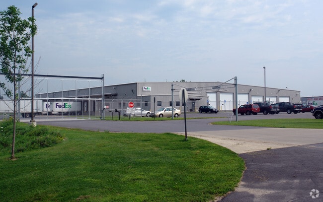
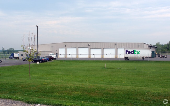
Property Record
82 Gateway Dr, Plattsburgh, NY 12901


Property Detail
82 Gateway Dr
092400-167-000-0002-009-000-0000
CLINTON
Warehouse
New York
B and X Area of moderate flood hazard, usually the area between the limits of the 100-year and 500-year floods.
9.000
2025
7.36 AC
2025
Beekmantown
100600
Other Market Areas
30,964 SF
Plattsburgh, NY
NEARBY LISTINGS FOR SALE OR LEASE
-
-
View all Plattsburgh listings for sale on LoopNet.com
DEMOGRAPHICS near 82 Gateway Dr
1 mile
3 mile
5 mile
2025 Total Population
216
2,203
8,688
2030 Population
215
2,183
8,651
Pop Growth 2025-2030
(0.46%)
(0.91%)
(0.43%)
Average Age
45
44
44
2025 Total Households
97
950
3,755
HH Growth 2025-2030
0.00%
(0.95%)
(0.48%)
Median Household Inc
$81,250
$77,954
$80,947
Avg Household Size
2.20
2.30
2.20
2025 Avg HH Vehicles
2.00
2.00
2.00
Median Home Value
$266,666
$243,192
$205,873
Median Year Built
1975
1977
1976
Nearby Places
Map Layers
Map Styles
 Street
 Aerial
Transit
 Traffic
 Biking
Places
Listings with unknown addresses are not visible on the map
- Restaurants
- Banks
- Shops
- Fitness
- Groceries
PUBLIC TRANSPORTATION
COMMUTER RAIL
Drive
Walk
Distance
13 min
7.5 mi
AIRPORT
Plattsburgh International
Drive
Walk
Distance
Plattsburgh International
18 min
10.9 mi
Patrick Leahy Burlington International
Drive
Walk
Distance
Patrick Leahy Burlington International
71 min
33.5 mi
Nearby Properties
Address
Land Use
TOTAL SIZE
Lot Size
Zoning
Address
Land Use
TOTAL SIZE
Lot Size
Zoning
245,016 SF
46.50 AC
Address
Land Use
TOTAL SIZE
Lot Size
Zoning
1,729 SF
390.40 AC
Address
Land Use
TOTAL SIZE
Lot Size
Zoning
3,968 SF
156.60 AC
Address
Land Use
TOTAL SIZE
Lot Size
Zoning
2,709 SF
15.11 AC
Address
Land Use
TOTAL SIZE
Lot Size
Zoning
6,175 SF
50.30 AC
Address
Land Use
TOTAL SIZE
Lot Size
Zoning
59,800 SF
3.42 AC
Address
Land Use
TOTAL SIZE
Lot Size
Zoning
42,162 SF
7.93 AC
Address
Land Use
TOTAL SIZE
Lot Size
Zoning
100.40 AC
Address
Land Use
TOTAL SIZE
Lot Size
Zoning
17,142 SF
4.50 AC
C
Address
Land Use
TOTAL SIZE
Lot Size
Zoning
255.30 AC
Address
Land Use
TOTAL SIZE
Lot Size
Zoning
29,900 SF
3.05 AC
05 - COMME
Address
Land Use
TOTAL SIZE
Lot Size
Zoning
952 SF
54.85 AC
Address
Land Use
TOTAL SIZE
Lot Size
Zoning
6,624 SF
1.65 AC
Address
Land Use
TOTAL SIZE
Lot Size
Zoning
160.90 AC
Address
Land Use
TOTAL SIZE
Lot Size
Zoning
2,160 SF
3.64 AC
C
Address
Land Use
TOTAL SIZE
Lot Size
Zoning
27.30 AC
Address
Land Use
TOTAL SIZE
Lot Size
Zoning
3,538 SF
15.06 AC
Address
Land Use
TOTAL SIZE
Lot Size
Zoning
24,150 SF
2.47 AC
Address
Land Use
TOTAL SIZE
Lot Size
Zoning
6,306 SF
12.70 AC
Address
Land Use
TOTAL SIZE
Lot Size
Zoning
118.70 AC
01 - NOT Z
Address
Land Use
TOTAL SIZE
Lot Size
Zoning
116.10 AC
Address
Land Use
TOTAL SIZE
Lot Size
Zoning
1.10 AC
SC
Address
Land Use
TOTAL SIZE
Lot Size
Zoning
6,794 SF
7.06 AC
C
Address
Land Use
TOTAL SIZE
Lot Size
Zoning
20,000 SF
2.86 AC
Address
Land Use
TOTAL SIZE
Lot Size
Zoning
173.10 AC
Address
Land Use
TOTAL SIZE
Lot Size
Zoning
107 AC
Address
Land Use
TOTAL SIZE
Lot Size
Zoning
129.70 AC
Address
Land Use
TOTAL SIZE
Lot Size
Zoning
98.30 AC
Address
Land Use
TOTAL SIZE
Lot Size
Zoning
101.40 AC
The World's #1 Commercial Real Estate Marketplace
Connect with us
© 2026 CoStar Group
The information above has been obtained from sources believed reliable. While we do not doubt its accuracy we have not verified it and make no guarantee, warranty or representation about it. It is your responsibility to independently confirm its accuracy and completeness. Any projections, opinions, assumptions, or estimates used are for example only and do not represent the current or future performance of the property. The value of this transaction to you depends on tax and other factors which should be evaluated by your tax, financial, and legal advisors. You and your advisors should conduct a careful, independent investigation of the property to determine to your satisfaction the suitability of the property for your needs.