Property Record
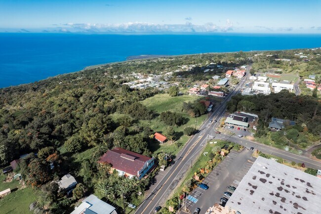
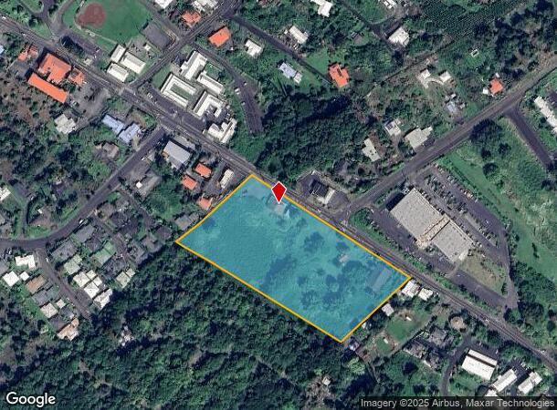
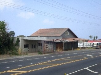
82 Mamalahoa Hwy, Captain Cook, HI 96704
NEARBY LISTINGS FOR SALE OR LEASE
-
-
View all Captain Cook listings for sale on LoopNet.com
Property Detail
82 Mamalahoa Hwy
3-8-2-003-005-0000
Kiloa
Agriculturalland
7.098 AC DES POR RPGR 867
X
Hawaii
1551661231F
Hawaii
2024
7.10 AC
2025
Kona/West Big Island
021300
Hawaii
8,236 SF
Hilo, HI
DEMOGRAPHICS near 82 Mamalahoa Hwy
1 Mile
3 Mile
5 Mile
2024 Total Population
2,391
6,538
9,322
2029 Population
2,470
6,778
9,643
Pop Growth 2024-2029
+ 3.30%
+ 3.67%
+ 3.44%
Average Age
45
45
45
2024 Total Households
822
2,255
3,189
HH Growth 2024-2029
+ 2.80%
+ 3.28%
+ 3.04%
Median Household Inc
$72,856
$80,371
$78,782
Avg Household Size
2.70
2.70
2.70
2024 Avg HH Vehicles
2.00
2.00
2.00
Median Home Value
$677,801
$681,393
$685,484
Median Year Built
1977
1978
1977
Nearby Places
Map Layers
Map Styles
 Street
 Aerial
- Restaurants
- Banks
- Shops
- Fitness
- Groceries
PUBLIC TRANSPORTATION
AIRPORT
Ellison Onizuka Kona International at Keahole
DRIVE
WALK
Distance
Ellison Onizuka Kona International at Keahole
36 min
20.8 mi
SALE & LEASE HISTORY
LISTING DATE
SALE/LEASE

Oct 21, 2023
For Sale
Dec 28, 2023
For Sale
Nearby Properties
Address
Land Use
TOTAL SIZE
Lot Size
Zoning
Address
Land Use
TOTAL SIZE
Lot Size
Zoning
4,774 SF
1.15 AC
A-1a
Address
Land Use
TOTAL SIZE
Lot Size
Zoning
19,163 SF
15.56 AC
A-1a
Address
Land Use
TOTAL SIZE
Lot Size
Zoning
5,349 SF
1.73 AC
A-1a
Address
Land Use
TOTAL SIZE
Lot Size
Zoning
4,284 SF
1.42 AC
A-1a
Address
Land Use
TOTAL SIZE
Lot Size
Zoning
16,364 SF
5.84 AC
A-5a
Address
Land Use
TOTAL SIZE
Lot Size
Zoning
54,108 SF
15.20 AC
CV-10
Address
Land Use
TOTAL SIZE
Lot Size
Zoning
4,638 SF
1.25 AC
A-1a
Address
Land Use
TOTAL SIZE
Lot Size
Zoning
1,392.71 AC
A-1a
Address
Land Use
TOTAL SIZE
Lot Size
Zoning
27,840 SF
2.08 AC
CV-7.5
Address
Land Use
TOTAL SIZE
Lot Size
Zoning
5,204 SF
1.10 AC
A-1a
Address
Land Use
TOTAL SIZE
Lot Size
Zoning
4,682 SF
1.35 AC
A-1a
Address
Land Use
TOTAL SIZE
Lot Size
Zoning
30,714 SF
5.57 AC
RM-4
Address
Land Use
TOTAL SIZE
Lot Size
Zoning
157.10 AC
A-1a
Address
Land Use
TOTAL SIZE
Lot Size
Zoning
4,166 SF
1.58 AC
A-1a
Address
Land Use
TOTAL SIZE
Lot Size
Zoning
3,771 SF
1.34 AC
A-1a
Address
Land Use
TOTAL SIZE
Lot Size
Zoning
6,051 SF
17.28 AC
A-5a
Address
Land Use
TOTAL SIZE
Lot Size
Zoning
4,586 SF
1.19 AC
A-1a
Address
Land Use
TOTAL SIZE
Lot Size
Zoning
1.41 AC
A-1a
Address
Land Use
TOTAL SIZE
Lot Size
Zoning
4,774 SF
1.28 AC
A-1a
Address
Land Use
TOTAL SIZE
Lot Size
Zoning
5,035 SF
1.25 AC
A-1a
Address
Land Use
TOTAL SIZE
Lot Size
Zoning
3,386 SF
1 AC
A-1a
Address
Land Use
TOTAL SIZE
Lot Size
Zoning
2,016 SF
105.99 AC
A-5a
Address
Land Use
TOTAL SIZE
Lot Size
Zoning
4,561 SF
0.38 AC
OPEN
Address
Land Use
TOTAL SIZE
Lot Size
Zoning
2,864 SF
1.32 AC
A-1a
Address
Land Use
TOTAL SIZE
Lot Size
Zoning
5,181 SF
1.08 AC
A-1a
Address
Land Use
TOTAL SIZE
Lot Size
Zoning
3,745 SF
1.19 AC
A-1a
Address
Land Use
TOTAL SIZE
Lot Size
Zoning
3,837 SF
1.12 AC
A-1a
Address
Land Use
TOTAL SIZE
Lot Size
Zoning
42,312 SF
1.25 AC
CV-7.5
Address
Land Use
TOTAL SIZE
Lot Size
Zoning
6,120 SF
5 AC
A-5a
Address
Land Use
TOTAL SIZE
Lot Size
Zoning
4,587 SF
1.06 AC
A-1a
The World's #1 Commercial Real Estate Marketplace
Connect with us
© 2025 CoStar Group
The information above has been obtained from sources believed reliable. While we do not doubt its accuracy we have not verified it and make no guarantee, warranty or representation about it. It is your responsibility to independently confirm its accuracy and completeness. Any projections, opinions, assumptions, or estimates used are for example only and do not represent the current or future performance of the property. The value of this transaction to you depends on tax and other factors which should be evaluated by your tax, financial, and legal advisors. You and your advisors should conduct a careful, independent investigation of the property to determine to your satisfaction the suitability of the property for your needs.