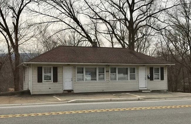
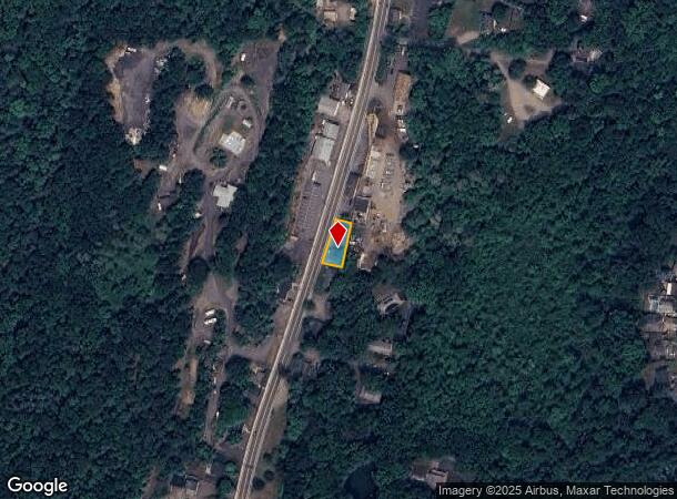
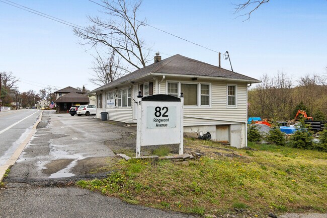
Property Record
82 Ringwood Ave, Ringwood, NJ 07456
NEARBY LISTINGS FOR SALE OR LEASE
Property Detail
82 Ringwood Ave
11-00748-0000-00086
Passaic
Officebuilding
New Jersey
X
86
34031C0133G
0.12 AC
2024
Upper Suburban Passaic
2025
Northern New Jersey
216702
New York-Jersey City-White Plains, NY-NJ
DEMOGRAPHICS near 82 Ringwood Ave
1 mile
3 mile
5 mile
2024 Total Population
4,408
21,087
64,496
2029 Population
4,286
20,841
64,110
Pop Growth 2024-2029
(2.77%)
(1.17%)
(0.60%)
Average Age
42
44
43
2024 Total Households
1,630
7,797
23,109
HH Growth 2024-2029
(3.13%)
(1.40%)
(0.77%)
Median Household Inc
$114,510
$116,413
$121,718
Avg Household Size
2.70
2.60
2.70
2024 Avg HH Vehicles
2.00
2.00
2.00
Median Home Value
$360,886
$370,335
$407,794
Median Year Built
1963
1967
1964
Nearby Places
Map Layers
Map Styles
 Street
 Aerial
Transit
 Traffic
 Biking
Places
Listings with unknown addresses are not visible on the map
- Restaurants
- Banks
- Shops
- Fitness
- Groceries
PUBLIC TRANSPORTATION
AIRPORT
Newark Liberty International
Drive
Walk
Distance
Newark Liberty International
44 min
34.6 mi
LaGuardia
Drive
Walk
Distance
LaGuardia
55 min
38.2 mi
Westchester County
Drive
Walk
Distance
Westchester County
64 min
44.2 mi
Freight Ports
Maher Terminal
Drive
Walk
Distance
Maher Terminal
51 min
34.4 mi
SALE & LEASE HISTORY
LISTING DATE
SALE/LEASE

Feb 15, 2023
For Sale
Dec 23, 2020
For Sale
Aug 20, 2018
For Sale
Apr 05, 2024
For Sale
Nearby Properties
Address
Land Use
TOTAL SIZE
Lot Size
Zoning
Address
Land Use
TOTAL SIZE
Lot Size
Zoning
Address
Land Use
TOTAL SIZE
Lot Size
Zoning
23.48 AC
Address
Land Use
TOTAL SIZE
Lot Size
Zoning
1,675.67 AC
Address
Land Use
TOTAL SIZE
Lot Size
Zoning
574.63 AC
C200
Address
Land Use
TOTAL SIZE
Lot Size
Zoning
11.92 AC
Address
Land Use
TOTAL SIZE
Lot Size
Zoning
26.10 AC
R15
Address
Land Use
TOTAL SIZE
Lot Size
Zoning
196.40 AC
C
Address
Land Use
TOTAL SIZE
Lot Size
Zoning
166 AC
C
Address
Land Use
TOTAL SIZE
Lot Size
Zoning
37 AC
R-20
Address
Land Use
TOTAL SIZE
Lot Size
Zoning
5.40 AC
B
Address
Land Use
TOTAL SIZE
Lot Size
Zoning
2,484 SF
5 AC
Address
Land Use
TOTAL SIZE
Lot Size
Zoning
144.70 AC
C
Address
Land Use
TOTAL SIZE
Lot Size
Zoning
5.91 AC
Address
Land Use
TOTAL SIZE
Lot Size
Zoning
13.40 AC
CO
Address
Land Use
TOTAL SIZE
Lot Size
Zoning
1.67 AC
Address
Land Use
TOTAL SIZE
Lot Size
Zoning
931.97 AC
P
Address
Land Use
TOTAL SIZE
Lot Size
Zoning
5.53 AC
Address
Land Use
TOTAL SIZE
Lot Size
Zoning
Address
Land Use
TOTAL SIZE
Lot Size
Zoning
479 AC
Address
Land Use
TOTAL SIZE
Lot Size
Zoning
Address
Land Use
TOTAL SIZE
Lot Size
Zoning
2.30 AC
R10
Address
Land Use
TOTAL SIZE
Lot Size
Zoning
10.63 AC
Address
Land Use
TOTAL SIZE
Lot Size
Zoning
Address
Land Use
TOTAL SIZE
Lot Size
Zoning
5.70 AC
R10B
Address
Land Use
TOTAL SIZE
Lot Size
Zoning
38.59 AC
Address
Land Use
TOTAL SIZE
Lot Size
Zoning
2.64 AC
CO
Address
Land Use
TOTAL SIZE
Lot Size
Zoning
327.50 AC
R40
Address
Land Use
TOTAL SIZE
Lot Size
Zoning
356 AC
WRC
Address
Land Use
TOTAL SIZE
Lot Size
Zoning
0.64 AC
B
Address
Land Use
TOTAL SIZE
Lot Size
Zoning
64.89 AC
C
The World's #1 Commercial Real Estate Marketplace
Connect with us
© 2026 CoStar Group
The information above has been obtained from sources believed reliable. While we do not doubt its accuracy we have not verified it and make no guarantee, warranty or representation about it. It is your responsibility to independently confirm its accuracy and completeness. Any projections, opinions, assumptions, or estimates used are for example only and do not represent the current or future performance of the property. The value of this transaction to you depends on tax and other factors which should be evaluated by your tax, financial, and legal advisors. You and your advisors should conduct a careful, independent investigation of the property to determine to your satisfaction the suitability of the property for your needs.