Property Record
82 School Rd, Hampton, GA 30228


Property Detail
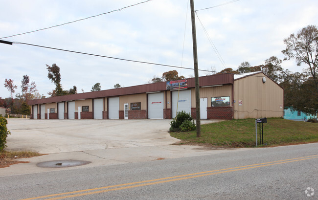
82 School Rd
500-05-019
0.87AC SCHOOL RD PB 5/54
Industrialgeneral
Spalding
B and X Area of moderate flood hazard, usually the area between the limits of the 100-year and 500-year floods.
Georgia
2025
0.87 AC
2025
S Clayton/Henry Cnty
160102
Atlanta
6,048 SF
Atlanta-Sandy Springs-Roswell, GA
NEARBY LISTINGS FOR SALE OR LEASE
-
-
View all Hampton listings for sale on LoopNet.com
DEMOGRAPHICS near 82 School Rd
1 mile
3 mile
5 mile
2024 Total Population
1,519
9,805
36,135
2029 Population
1,583
10,371
38,243
Pop Growth 2024-2029
+ 4.21%
+ 5.77%
+ 5.83%
Average Age
38
38
40
2024 Total Households
538
3,358
13,208
HH Growth 2024-2029
+ 4.28%
+ 5.69%
+ 5.81%
Median Household Inc
$49,739
$62,063
$70,908
Avg Household Size
2.80
2.90
2.70
2024 Avg HH Vehicles
2.00
2.00
2.00
Median Home Value
$184,433
$250,719
$271,764
Median Year Built
1991
1994
1997
Nearby Places
Map Layers
Map Styles
 Street
 Aerial
Transit
 Traffic
 Biking
Places
Listings with unknown addresses are not visible on the map
- Restaurants
- Banks
- Shops
- Fitness
- Groceries
PUBLIC TRANSPORTATION
AIRPORT
Hartsfield - Jackson Atlanta International
Drive
Walk
Distance
Hartsfield - Jackson Atlanta International
38 min
24.4 mi
SALE & LEASE HISTORY
LISTING DATE
SALE/LEASE

Mar 09, 2017
For Sale
Nearby Properties
Address
Land Use
TOTAL SIZE
Lot Size
Zoning
Address
Land Use
TOTAL SIZE
Lot Size
Zoning
1,424,654 SF
172.86 AC
Address
Land Use
TOTAL SIZE
Lot Size
Zoning
11,520 SF
8.77 AC
C-1B
Address
Land Use
TOTAL SIZE
Lot Size
Zoning
20 AC
AR-1
Address
Land Use
TOTAL SIZE
Lot Size
Zoning
21,542 SF
7.53 AC
C-1B
Address
Land Use
TOTAL SIZE
Lot Size
Zoning
2,160 SF
6.90 AC
C-1B
Address
Land Use
TOTAL SIZE
Lot Size
Zoning
5,751 SF
16.49 AC
C1
Address
Land Use
TOTAL SIZE
Lot Size
Zoning
594 SF
4.08 AC
C-1B
Address
Land Use
TOTAL SIZE
Lot Size
Zoning
39,681 SF
6.19 AC
C2
Address
Land Use
TOTAL SIZE
Lot Size
Zoning
341.53 AC
RA
Address
Land Use
TOTAL SIZE
Lot Size
Zoning
5,518 SF
11.39 AC
C-1
Address
Land Use
TOTAL SIZE
Lot Size
Zoning
19,500 SF
3.09 AC
C
Address
Land Use
TOTAL SIZE
Lot Size
Zoning
9,020 SF
3.30 AC
C1
Address
Land Use
TOTAL SIZE
Lot Size
Zoning
25,925 SF
8.25 AC
Address
Land Use
TOTAL SIZE
Lot Size
Zoning
308.50 AC
Address
Land Use
TOTAL SIZE
Lot Size
Zoning
16,800 SF
2.01 AC
C-1B
Address
Land Use
TOTAL SIZE
Lot Size
Zoning
30.24 AC
M1
Address
Land Use
TOTAL SIZE
Lot Size
Zoning
40,536 SF
6 AC
Address
Land Use
TOTAL SIZE
Lot Size
Zoning
10,200 SF
8.35 AC
Address
Land Use
TOTAL SIZE
Lot Size
Zoning
19,026 SF
4.75 AC
RA
Address
Land Use
TOTAL SIZE
Lot Size
Zoning
73,390 SF
6.35 AC
M2
Address
Land Use
TOTAL SIZE
Lot Size
Zoning
16,800 SF
2.66 AC
Address
Land Use
TOTAL SIZE
Lot Size
Zoning
9,100 SF
4.19 AC
Address
Land Use
TOTAL SIZE
Lot Size
Zoning
66 AC
C1/AR1
Address
Land Use
TOTAL SIZE
Lot Size
Zoning
13,556 SF
8.43 AC
C-1
Address
Land Use
TOTAL SIZE
Lot Size
Zoning
48,780 SF
3.84 AC
R2
Address
Land Use
TOTAL SIZE
Lot Size
Zoning
8,967 SF
3.46 AC
The World's #1 Commercial Real Estate Marketplace
Connect with us
© 2026 CoStar Group
The information above has been obtained from sources believed reliable. While we do not doubt its accuracy we have not verified it and make no guarantee, warranty or representation about it. It is your responsibility to independently confirm its accuracy and completeness. Any projections, opinions, assumptions, or estimates used are for example only and do not represent the current or future performance of the property. The value of this transaction to you depends on tax and other factors which should be evaluated by your tax, financial, and legal advisors. You and your advisors should conduct a careful, independent investigation of the property to determine to your satisfaction the suitability of the property for your needs.