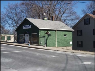
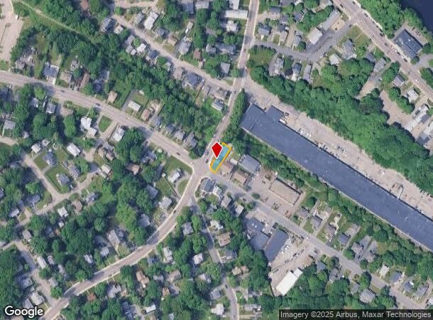
Property Record
82 Walnut St, Dedham, MA 02026
NEARBY LISTINGS FOR SALE OR LEASE
Property Detail
82 Walnut St
DEDH-000112-000000-000121
M-31A Madison East
Storebuilding
Norfolk
X
Massachusetts
25021C0182F
121
2025
0.11 AC
2025
Route 1 South
402200
Boston
572 SF
Boston-Cambridge-Newton, MA-NH
DEMOGRAPHICS near 82 Walnut St
1 Mile
3 Mile
5 Mile
2024 Total Population
15,924
99,189
252,120
2029 Population
15,543
95,596
243,933
Pop Growth 2024-2029
(2.39%)
(3.62%)
(3.25%)
Average Age
40
42
42
2024 Total Households
6,206
37,460
94,333
HH Growth 2024-2029
(2.55%)
(4.07%)
(3.70%)
Median Household Inc
$94,744
$104,381
$106,564
Avg Household Size
2.50
2.50
2.50
2024 Avg HH Vehicles
2.00
2.00
2.00
Median Home Value
$574,111
$652,607
$709,927
Median Year Built
1952
1954
1953
Nearby Places
Map Layers
Map Styles
 Street
 Aerial
- Restaurants
- Banks
- Shops
- Fitness
- Groceries
PUBLIC TRANSPORTATION
TRANSIT/SUBWAY
Endicott (Franklin Line - Massachusetts Bay Transportation Authority Commuter Rail (Purple Line))
DRIVE
WALK
Distance
Endicott (Franklin Line - Massachusetts Bay Transportation Authority Commuter Rail (Purple Line))
3 min
20 min
1.1 mi
COMMUTER RAIL
Endicott (Franklin Line - Massachusetts Bay Transportation Authority Commuter Rail (Purple Line))
DRIVE
WALK
Distance
Endicott (Franklin Line - Massachusetts Bay Transportation Authority Commuter Rail (Purple Line))
3 min
1.1 mi
Readville (Fairmount Line - Massachusetts Bay Transportation Authority Commuter Rail (Purple Line), Franklin Line - Massachusetts Bay Transportation Authority Commuter Rail (Purple Line))
DRIVE
WALK
Distance
Readville (Fairmount Line - Massachusetts Bay Transportation Authority Commuter Rail (Purple Line), Franklin Line - Massachusetts Bay Transportation Authority Commuter Rail (Purple Line))
5 min
1.7 mi
AIRPORT
General Edward Lawrence Logan International
DRIVE
WALK
Distance
General Edward Lawrence Logan International
28 min
14.0 mi
Freight Ports
Port of Boston
DRIVE
WALK
Distance
Port of Boston
26 min
12.5 mi
SALE & LEASE HISTORY
LISTING DATE
SALE/LEASE

May 30, 2017
For Sale
Jun 15, 2017
For Sale
Nearby Properties
Address
Land Use
TOTAL SIZE
Lot Size
Zoning
Address
Land Use
TOTAL SIZE
Lot Size
Zoning
355,941 SF
4.60 AC
A
Address
Land Use
TOTAL SIZE
Lot Size
Zoning
413,827 SF
9.49 AC
RDO
Address
Land Use
TOTAL SIZE
Lot Size
Zoning
179.13 AC
E
Address
Land Use
TOTAL SIZE
Lot Size
Zoning
225,042 SF
63.16 AC
RA
Address
Land Use
TOTAL SIZE
Lot Size
Zoning
11.66 AC
LM
Address
Land Use
TOTAL SIZE
Lot Size
Zoning
34.93 AC
LM
Address
Land Use
TOTAL SIZE
Lot Size
Zoning
270,991 SF
33.25 AC
RA
Address
Land Use
TOTAL SIZE
Lot Size
Zoning
21,830 SF
158.48 AC
E
Address
Land Use
TOTAL SIZE
Lot Size
Zoning
226,304 SF
2.89 AC
Address
Land Use
TOTAL SIZE
Lot Size
Zoning
18,451 SF
19.07 AC
Address
Land Use
TOTAL SIZE
Lot Size
Zoning
26,569 SF
45.93 AC
RC
Address
Land Use
TOTAL SIZE
Lot Size
Zoning
8.18 AC
B
Address
Land Use
TOTAL SIZE
Lot Size
Zoning
351,699 SF
27.36 AC
Address
Land Use
TOTAL SIZE
Lot Size
Zoning
22.95 AC
E
Address
Land Use
TOTAL SIZE
Lot Size
Zoning
132,917 SF
24 AC
RE
Address
Land Use
TOTAL SIZE
Lot Size
Zoning
267,103 SF
20.23 AC
10
Address
Land Use
TOTAL SIZE
Lot Size
Zoning
180,022 SF
3.74 AC
Address
Land Use
TOTAL SIZE
Lot Size
Zoning
83,891 SF
3.47 AC
RA
Address
Land Use
TOTAL SIZE
Lot Size
Zoning
475,102 SF
36.81 AC
A
Address
Land Use
TOTAL SIZE
Lot Size
Zoning
45.72 AC
LM
Address
Land Use
TOTAL SIZE
Lot Size
Zoning
15 AC
Address
Land Use
TOTAL SIZE
Lot Size
Zoning
141,322 SF
36.84 AC
Address
Land Use
TOTAL SIZE
Lot Size
Zoning
100,963 SF
17.69 AC
A
Address
Land Use
TOTAL SIZE
Lot Size
Zoning
94.34 AC
E
Address
Land Use
TOTAL SIZE
Lot Size
Zoning
81,796 SF
11.87 AC
Address
Land Use
TOTAL SIZE
Lot Size
Zoning
195,690 SF
14.98 AC
NV
Address
Land Use
TOTAL SIZE
Lot Size
Zoning
266,074 SF
44.50 AC
E
Address
Land Use
TOTAL SIZE
Lot Size
Zoning
61,044 SF
5.60 AC
Address
Land Use
TOTAL SIZE
Lot Size
Zoning
18.01 AC
GB
Address
Land Use
TOTAL SIZE
Lot Size
Zoning
11.39 AC
B
The World's #1 Commercial Real Estate Marketplace
Connect with us
© 2026 CoStar Group
The information above has been obtained from sources believed reliable. While we do not doubt its accuracy we have not verified it and make no guarantee, warranty or representation about it. It is your responsibility to independently confirm its accuracy and completeness. Any projections, opinions, assumptions, or estimates used are for example only and do not represent the current or future performance of the property. The value of this transaction to you depends on tax and other factors which should be evaluated by your tax, financial, and legal advisors. You and your advisors should conduct a careful, independent investigation of the property to determine to your satisfaction the suitability of the property for your needs.