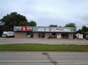
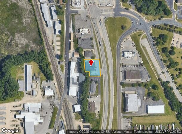
Property Record
820 2Nd Ave S, Onalaska, WI 54650
NEARBY LISTINGS FOR SALE OR LEASE
Property Detail
820 2Nd Ave S
018-000951-005
CERTIFIED SURVEY MAP NO. 137 VOL 3 DOC NO. 986492 LOT 1 EX N 190FT & N 40FT LOT 2 & PRT OUTLOT 1 LYG E OF & ADJ TO SUBJ TO & T/W ESMTS IN V1080 P115
Commercialnec
La Crosse
X
Wisconsin
55063C0163D
1-2
2023
0.36 AC
2023
Other Market Areas
010500
La Crosse-Onalaska, WI-MN
DEMOGRAPHICS near 820 2Nd Ave S
1 Mile
3 Mile
5 Mile
2024 Total Population
5,526
34,890
65,428
2029 Population
5,614
35,268
66,119
Pop Growth 2024-2029
+ 1.59%
+ 1.08%
+ 1.06%
Average Age
42
41
39
2024 Total Households
2,541
14,990
26,857
HH Growth 2024-2029
+ 1.34%
+ 0.85%
+ 1.03%
Median Household Inc
$57,550
$60,306
$56,162
Avg Household Size
2.10
2.30
2.20
2024 Avg HH Vehicles
2.00
2.00
2.00
Median Home Value
$168,338
$218,470
$227,691
Median Year Built
1977
1977
1977
Nearby Places
Map Layers
Map Styles
 Street
 Aerial
- Restaurants
- Banks
- Shops
- Fitness
- Groceries
PUBLIC TRANSPORTATION
COMMUTER RAIL
DRIVE
WALK
Distance
8 min
3.4 mi
AIRPORT
La Crosse Regional
DRIVE
WALK
Distance
La Crosse Regional
8 min
3.4 mi
Nearby Properties
Address
Land Use
TOTAL SIZE
Lot Size
Zoning
Address
Land Use
TOTAL SIZE
Lot Size
Zoning
45.53 AC
MZA
Address
Land Use
TOTAL SIZE
Lot Size
Zoning
42.20 AC
MZA
Address
Land Use
TOTAL SIZE
Lot Size
Zoning
12.60 AC
MZA
Address
Land Use
TOTAL SIZE
Lot Size
Zoning
7.68 AC
MZA
Address
Land Use
TOTAL SIZE
Lot Size
Zoning
14.59 AC
MZA
Address
Land Use
TOTAL SIZE
Lot Size
Zoning
54.26 AC
MZA
Address
Land Use
TOTAL SIZE
Lot Size
Zoning
11.40 AC
MZA
Address
Land Use
TOTAL SIZE
Lot Size
Zoning
29.80 AC
MZA
Address
Land Use
TOTAL SIZE
Lot Size
Zoning
12,500 SF
5.12 AC
MZA
Address
Land Use
TOTAL SIZE
Lot Size
Zoning
14.61 AC
MZA
Address
Land Use
TOTAL SIZE
Lot Size
Zoning
4.81 AC
Address
Land Use
TOTAL SIZE
Lot Size
Zoning
2.52 AC
Address
Land Use
TOTAL SIZE
Lot Size
Zoning
19.67 AC
MZA
Address
Land Use
TOTAL SIZE
Lot Size
Zoning
15.41 AC
MZA
Address
Land Use
TOTAL SIZE
Lot Size
Zoning
5.29 AC
MZA
Address
Land Use
TOTAL SIZE
Lot Size
Zoning
2.63 AC
MZA
Address
Land Use
TOTAL SIZE
Lot Size
Zoning
19.98 AC
Address
Land Use
TOTAL SIZE
Lot Size
Zoning
5.98 AC
MZA
Address
Land Use
TOTAL SIZE
Lot Size
Zoning
4.40 AC
Address
Land Use
TOTAL SIZE
Lot Size
Zoning
33.17 AC
MZA
Address
Land Use
TOTAL SIZE
Lot Size
Zoning
5.90 AC
Address
Land Use
TOTAL SIZE
Lot Size
Zoning
10.64 AC
MZA
Address
Land Use
TOTAL SIZE
Lot Size
Zoning
11.04 AC
MZA
Address
Land Use
TOTAL SIZE
Lot Size
Zoning
10.92 AC
MZA
Address
Land Use
TOTAL SIZE
Lot Size
Zoning
8.40 AC
MZA
Address
Land Use
TOTAL SIZE
Lot Size
Zoning
8.98 AC
MZA
Address
Land Use
TOTAL SIZE
Lot Size
Zoning
3.75 AC
Address
Land Use
TOTAL SIZE
Lot Size
Zoning
7.59 AC
MZA
Address
Land Use
TOTAL SIZE
Lot Size
Zoning
8.39 AC
MZA
Address
Land Use
TOTAL SIZE
Lot Size
Zoning
6.90 AC
MZA
The World's #1 Commercial Real Estate Marketplace
Connect with us
© 2026 CoStar Group
The information above has been obtained from sources believed reliable. While we do not doubt its accuracy we have not verified it and make no guarantee, warranty or representation about it. It is your responsibility to independently confirm its accuracy and completeness. Any projections, opinions, assumptions, or estimates used are for example only and do not represent the current or future performance of the property. The value of this transaction to you depends on tax and other factors which should be evaluated by your tax, financial, and legal advisors. You and your advisors should conduct a careful, independent investigation of the property to determine to your satisfaction the suitability of the property for your needs.