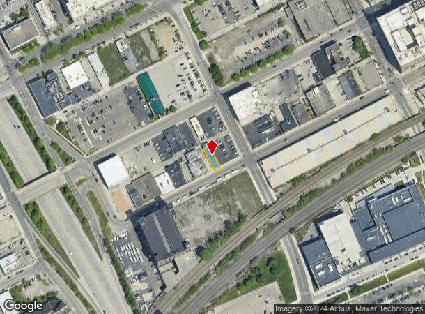
Property Record
820 W Baltimore St, Detroit, MI 48202
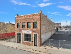
This Property Is For Sale
NEARBY LISTINGS FOR SALE OR LEASE
Property Detail
820 W Baltimore St
04-001379
Leavitts
Wholesaleoutletdiscountstore
N BALTIMORE 170 LEAVITTS SUB L9 P17 PLATS, W C R 4/64 30 X 107.50
X
Wayne
26163C0280E
Michigan
2024
0.07 AC
2025
Detroit-New Center
533900
Detroit
6,912 SF
Detroit-Warren-Dearborn, MI
DEMOGRAPHICS near 820 W Baltimore St
1 Mile
3 Mile
5 Mile
2024 Total Population
17,847
142,019
344,570
2029 Population
17,762
142,348
344,743
Pop Growth 2024-2029
(0.48%)
+ 0.23%
+ 0.05%
Average Age
36
38
38
2024 Total Households
8,511
61,923
141,294
HH Growth 2024-2029
(0.31%)
+ 0.43%
+ 0.22%
Median Household Inc
$32,137
$33,380
$34,684
Avg Household Size
1.80
2.10
2.30
2024 Avg HH Vehicles
1.00
1.00
1.00
Median Home Value
$206,932
$104,500
$86,355
Median Year Built
1948
1948
1948
Nearby Places
- Restaurants
- Banks
- Shops
- Fitness
- Groceries
PUBLIC TRANSPORTATION
COMMUTER RAIL
DRIVE
WALK
Distance
2 min
8 min
0.4 mi
DRIVE
WALK
Distance
16 min
7.3 mi
AIRPORT
Windsor International
DRIVE
WALK
Distance
Windsor International
29 min
13.1 mi
Detroit Metro Wayne County
DRIVE
WALK
Distance
Detroit Metro Wayne County
32 min
21.5 mi
Freight Ports
DRIVE
WALK
Distance
78 min
62.3 mi
Nearby Properties
Address
Land Use
TOTAL SIZE
Lot Size
Zoning
Address
Land Use
TOTAL SIZE
Lot Size
Zoning
3,032,363 SF
24.24 AC
SD5
Address
Land Use
TOTAL SIZE
Lot Size
Zoning
409,438 SF
0.83 AC
B6
Address
Land Use
TOTAL SIZE
Lot Size
Zoning
1,409,416 SF
13.53 AC
R6
Address
Land Use
TOTAL SIZE
Lot Size
Zoning
1,553,311 SF
3.05 AC
SD5
Address
Land Use
TOTAL SIZE
Lot Size
Zoning
1,994,989 SF
4.97 AC
B5
Address
Land Use
TOTAL SIZE
Lot Size
Zoning
873,048 SF
7.70 AC
R6
Address
Land Use
TOTAL SIZE
Lot Size
Zoning
1,017,009 SF
1.35 AC
R6
Address
Land Use
TOTAL SIZE
Lot Size
Zoning
848,598 SF
8.78 AC
SD5
Address
Land Use
TOTAL SIZE
Lot Size
Zoning
252,150 SF
2.46 AC
SD5
Address
Land Use
TOTAL SIZE
Lot Size
Zoning
185,300 SF
3.36 AC
SD5
Address
Land Use
TOTAL SIZE
Lot Size
Zoning
1,004,872 SF
1.05 AC
PCA
Address
Land Use
TOTAL SIZE
Lot Size
Zoning
3,793,609 SF
265.70 AC
M4
Address
Land Use
TOTAL SIZE
Lot Size
Zoning
895,279 SF
3.58 AC
PCA
Address
Land Use
TOTAL SIZE
Lot Size
Zoning
1,149,710 SF
1.07 AC
B5
Address
Land Use
TOTAL SIZE
Lot Size
Zoning
503,688 SF
Address
Land Use
TOTAL SIZE
Lot Size
Zoning
919,213 SF
B5
Address
Land Use
TOTAL SIZE
Lot Size
Zoning
568,546 SF
B5
Address
Land Use
TOTAL SIZE
Lot Size
Zoning
874,160 SF
9.91 AC
R6
Address
Land Use
TOTAL SIZE
Lot Size
Zoning
306,496 SF
1.91 AC
R6
Address
Land Use
TOTAL SIZE
Lot Size
Zoning
187,652 SF
Address
Land Use
TOTAL SIZE
Lot Size
Zoning
268,746 SF
B5
Address
Land Use
TOTAL SIZE
Lot Size
Zoning
576,286 SF
1.66 AC
B4
Address
Land Use
TOTAL SIZE
Lot Size
Zoning
167,719 SF
2.18 AC
SD5
Address
Land Use
TOTAL SIZE
Lot Size
Zoning
328,284 SF
768.89 AC
PD
Address
Land Use
TOTAL SIZE
Lot Size
Zoning
268,114 SF
2.46 AC
B6
Address
Land Use
TOTAL SIZE
Lot Size
Zoning
324,379 SF
4.97 AC
B5
Address
Land Use
TOTAL SIZE
Lot Size
Zoning
246,212 SF
B5
Address
Land Use
TOTAL SIZE
Lot Size
Zoning
334,904 SF
B5
Address
Land Use
TOTAL SIZE
Lot Size
Zoning
1,017,597 SF
2.73 AC
B5
Address
Land Use
TOTAL SIZE
Lot Size
Zoning
511,056 SF
0.81 AC
PCA
The World's #1 Commercial Real Estate Marketplace
Connect with us
© 2025 CoStar Group
The information above has been obtained from sources believed reliable. While we do not doubt its accuracy we have not verified it and make no guarantee, warranty or representation about it. It is your responsibility to independently confirm its accuracy and completeness. Any projections, opinions, assumptions, or estimates used are for example only and do not represent the current or future performance of the property. The value of this transaction to you depends on tax and other factors which should be evaluated by your tax, financial, and legal advisors. You and your advisors should conduct a careful, independent investigation of the property to determine to your satisfaction the suitability of the property for your needs.