Property Record
820 Chapman Rd, Byron, GA 31008


Property Detail
820 Chapman Rd
Warner Robins, GA
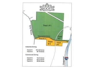
PAR 1+2 & TR A1+A2 / 583.61 AC \ LL1-2&25-26
056-023
PEACH
Privatepreserveopenspacevacantlandforestlandconservation
Georgia
C-3 & I-1
1+2+a1
A Areas with a 1% annual chance of flooding and a 26% chance of flooding over the life of a 30-year mortgage.
583.61 AC
2025
Perry/Warner Robins
2025
Other Market Areas
040104
NEARBY LISTINGS FOR SALE OR LEASE
DEMOGRAPHICS near 820 Chapman Rd
1 mile
3 mile
5 mile
2025 Total Population
509
7,563
31,608
2030 Population
519
7,743
32,604
Pop Growth 2025-2030
+ 1.96%
+ 2.38%
+ 3.15%
Average Age
44
42
41
2025 Total Households
216
2,989
11,882
HH Growth 2025-2030
+ 1.85%
+ 2.41%
+ 3.23%
Median Household Inc
$101,786
$80,335
$80,909
Avg Household Size
2.40
2.50
2.60
2025 Avg HH Vehicles
2.00
2.00
2.00
Median Home Value
$261,999
$201,570
$223,827
Median Year Built
2000
1991
1995
Nearby Places
Map Layers
Map Styles
 Street
 Aerial
Transit
 Traffic
 Biking
Places
Listings with unknown addresses are not visible on the map
- Restaurants
- Banks
- Shops
- Fitness
- Groceries
Nearby Properties
Address
Land Use
TOTAL SIZE
Lot Size
Zoning
Address
Land Use
TOTAL SIZE
Lot Size
Zoning
10,000 SF
1,163 AC
R-AG
Address
Land Use
TOTAL SIZE
Lot Size
Zoning
10,000 SF
43.93 AC
I-1
Address
Land Use
TOTAL SIZE
Lot Size
Zoning
2,116 SF
10.10 AC
C-1
Address
Land Use
TOTAL SIZE
Lot Size
Zoning
80,825 SF
7.20 AC
I-1
Address
Land Use
TOTAL SIZE
Lot Size
Zoning
47,568 SF
1.51 AC
C-3
Address
Land Use
TOTAL SIZE
Lot Size
Zoning
11,864 SF
16.72 AC
M-1
Address
Land Use
TOTAL SIZE
Lot Size
Zoning
42,056 SF
2.14 AC
C-3
Address
Land Use
TOTAL SIZE
Lot Size
Zoning
58,534 SF
7.82 AC
MULTI
Address
Land Use
TOTAL SIZE
Lot Size
Zoning
35,004 SF
1.45 AC
C-3
Address
Land Use
TOTAL SIZE
Lot Size
Zoning
336 SF
32.89 AC
PDI
Address
Land Use
TOTAL SIZE
Lot Size
Zoning
17,388 SF
7.02 AC
MULTI
Address
Land Use
TOTAL SIZE
Lot Size
Zoning
1,800 SF
33 AC
I-1
Address
Land Use
TOTAL SIZE
Lot Size
Zoning
24,400 SF
7 AC
MULTI
Address
Land Use
TOTAL SIZE
Lot Size
Zoning
26,131 SF
5.96 AC
C-1
Address
Land Use
TOTAL SIZE
Lot Size
Zoning
57,888 SF
1.01 AC
I-1
Address
Land Use
TOTAL SIZE
Lot Size
Zoning
54,175 SF
12.72 AC
C-3
Address
Land Use
TOTAL SIZE
Lot Size
Zoning
5,110 SF
2.03 AC
C-3
Address
Land Use
TOTAL SIZE
Lot Size
Zoning
35,784 SF
6.23 AC
C-3
Address
Land Use
TOTAL SIZE
Lot Size
Zoning
8,378 SF
7.20 AC
PDC
Address
Land Use
TOTAL SIZE
Lot Size
Zoning
12,026 SF
11.75 AC
R-1
Address
Land Use
TOTAL SIZE
Lot Size
Zoning
5,346 SF
2.13 AC
C-3
Address
Land Use
TOTAL SIZE
Lot Size
Zoning
12,154 SF
15.06 AC
R-1
Address
Land Use
TOTAL SIZE
Lot Size
Zoning
8,810 SF
5.48 AC
C-3
Address
Land Use
TOTAL SIZE
Lot Size
Zoning
7,232 SF
5.25 AC
C-1
Address
Land Use
TOTAL SIZE
Lot Size
Zoning
44,700 SF
10.33 AC
I-1
Address
Land Use
TOTAL SIZE
Lot Size
Zoning
15,946 SF
2.26 AC
C-2
Address
Land Use
TOTAL SIZE
Lot Size
Zoning
3,000 SF
6.19 AC
C-3
Address
Land Use
TOTAL SIZE
Lot Size
Zoning
3,500 SF
2.90 AC
C-1
Address
Land Use
TOTAL SIZE
Lot Size
Zoning
14,792 SF
3.97 AC
R-2
Address
Land Use
TOTAL SIZE
Lot Size
Zoning
8,188 SF
3 AC
C-2
The World's #1 Commercial Real Estate Marketplace
Connect with us
© 2026 CoStar Group
The information above has been obtained from sources believed reliable. While we do not doubt its accuracy we have not verified it and make no guarantee, warranty or representation about it. It is your responsibility to independently confirm its accuracy and completeness. Any projections, opinions, assumptions, or estimates used are for example only and do not represent the current or future performance of the property. The value of this transaction to you depends on tax and other factors which should be evaluated by your tax, financial, and legal advisors. You and your advisors should conduct a careful, independent investigation of the property to determine to your satisfaction the suitability of the property for your needs.