Property Record
820 S Post Rd, Indianapolis, IN 46239
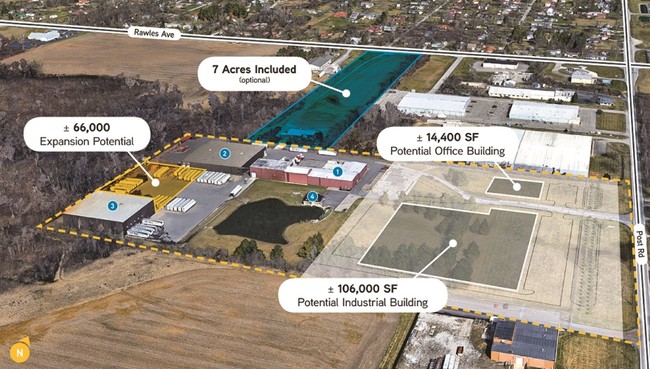

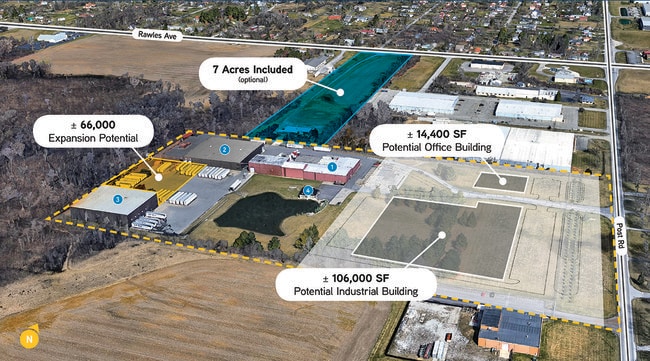
Property Detail
820 S Post Rd
49-09-07-112-002.000-700
WOLTERS INDUSTRIAL COMMERCIAL PLAT L1
Lightindustrial
Marion
ZO01
Indiana
B and X Area of moderate flood hazard, usually the area between the limits of the 100-year and 500-year floods.
1
2024
11.28 AC
2025
Washington Square
361401
Indianapolis
70,802 SF
Indianapolis-Carmel-Greenwood, IN
NEARBY LISTINGS FOR SALE OR LEASE
DEMOGRAPHICS near 820 S Post Rd
1 mile
3 mile
5 mile
2025 Total Population
2,898
45,588
164,416
2030 Population
2,953
45,889
166,937
Pop Growth 2025-2030
+ 1.90%
+ 0.66%
+ 1.53%
Average Age
38
39
38
2025 Total Households
1,157
17,716
64,062
HH Growth 2025-2030
+ 1.90%
+ 0.69%
+ 1.53%
Median Household Inc
$62,203
$69,090
$64,084
Avg Household Size
2.50
2.50
2.50
2025 Avg HH Vehicles
1.00
2.00
2.00
Median Home Value
$193,030
$221,667
$212,651
Median Year Built
1990
1973
1968
Nearby Places
Map Layers
Map Styles
 Street
 Aerial
Layers
 Traffic
 Biking
Places
Listings with unknown addresses are not visible on the map
- Restaurants
- Banks
- Shops
- Fitness
- Groceries
PUBLIC TRANSPORTATION
COMMUTER RAIL
Drive
Walk
Distance
19 min
9.2 mi
AIRPORT
Indianapolis International
Drive
Walk
Distance
Indianapolis International
40 min
21.3 mi
SALE & LEASE HISTORY
LISTING DATE
SALE/LEASE

Oct 04, 2017
For Sale
Nov 07, 2019
For Lease
May 15, 2017
For Sale
May 09, 2017
For Sale
Apr 27, 2017
For Lease
Nearby Properties
Address
Land Use
TOTAL SIZE
Lot Size
Zoning
Address
Land Use
TOTAL SIZE
Lot Size
Zoning
584,250 SF
42.54 AC
ZO01
Address
Land Use
TOTAL SIZE
Lot Size
Zoning
47.10 AC
ZO01
Address
Land Use
TOTAL SIZE
Lot Size
Zoning
9,888 SF
124.20 AC
ZO01
Address
Land Use
TOTAL SIZE
Lot Size
Zoning
4,379 SF
11.48 AC
ZO01
Address
Land Use
TOTAL SIZE
Lot Size
Zoning
768,000 SF
29.62 AC
ZO03
Address
Land Use
TOTAL SIZE
Lot Size
Zoning
5,560 SF
10.88 AC
ZO01
Address
Land Use
TOTAL SIZE
Lot Size
Zoning
3,132 SF
20.50 AC
Address
Land Use
TOTAL SIZE
Lot Size
Zoning
133,257 SF
93.03 AC
ZO01
Address
Land Use
TOTAL SIZE
Lot Size
Zoning
170,000 SF
11.29 AC
ZO01
Address
Land Use
TOTAL SIZE
Lot Size
Zoning
169,094 SF
10.43 AC
ZO01
Address
Land Use
TOTAL SIZE
Lot Size
Zoning
1,768 SF
30.88 AC
ZO01
Address
Land Use
TOTAL SIZE
Lot Size
Zoning
198,375 SF
24.52 AC
ZO01
Address
Land Use
TOTAL SIZE
Lot Size
Zoning
8,054 SF
20.62 AC
Address
Land Use
TOTAL SIZE
Lot Size
Zoning
140,976 SF
15.46 AC
ZO01
Address
Land Use
TOTAL SIZE
Lot Size
Zoning
213,102 SF
14.51 AC
Address
Land Use
TOTAL SIZE
Lot Size
Zoning
234,064 SF
29.49 AC
ZO01
Address
Land Use
TOTAL SIZE
Lot Size
Zoning
3,832 SF
12.77 AC
ZO01
Address
Land Use
TOTAL SIZE
Lot Size
Zoning
616,065 SF
51.20 AC
ZO01
Address
Land Use
TOTAL SIZE
Lot Size
Zoning
67,252 SF
7.50 AC
ZO01
Address
Land Use
TOTAL SIZE
Lot Size
Zoning
1,538 SF
14.49 AC
ZO01
Address
Land Use
TOTAL SIZE
Lot Size
Zoning
46,800 SF
49.64 AC
ZO01
Address
Land Use
TOTAL SIZE
Lot Size
Zoning
115,550 SF
11.58 AC
ZO01
Address
Land Use
TOTAL SIZE
Lot Size
Zoning
53,988 SF
13.35 AC
ZO01
Address
Land Use
TOTAL SIZE
Lot Size
Zoning
41,530 SF
2.78 AC
ZO01
Address
Land Use
TOTAL SIZE
Lot Size
Zoning
409,096 SF
26.01 AC
Address
Land Use
TOTAL SIZE
Lot Size
Zoning
64,768 SF
7.08 AC
ZO01
Address
Land Use
TOTAL SIZE
Lot Size
Zoning
103,032 SF
10.60 AC
Address
Land Use
TOTAL SIZE
Lot Size
Zoning
13,712 SF
26.10 AC
ZO01
Address
Land Use
TOTAL SIZE
Lot Size
Zoning
113,863 SF
13.60 AC
Address
Land Use
TOTAL SIZE
Lot Size
Zoning
36,144 SF
5.31 AC
ZO01
The World's #1 Commercial Real Estate Marketplace
Connect with us
© 2026 CoStar Group
The information above has been obtained from sources believed reliable. While we do not doubt its accuracy we have not verified it and make no guarantee, warranty or representation about it. It is your responsibility to independently confirm its accuracy and completeness. Any projections, opinions, assumptions, or estimates used are for example only and do not represent the current or future performance of the property. The value of this transaction to you depends on tax and other factors which should be evaluated by your tax, financial, and legal advisors. You and your advisors should conduct a careful, independent investigation of the property to determine to your satisfaction the suitability of the property for your needs.