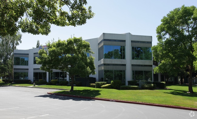
Property Record
820 Stillwater Rd, West Sacramento, CA 95605


NEARBY LISTINGS FOR SALE OR LEASE
Property Detail
820 Stillwater Rd
Sacramento-Roseville-Folsom, CA
Riverside Centre
014-670-014-000
SD3562 RIVERSIDE CENTRE L 3
Officebuilding
Yolo
ARE
California
06067C0160J
3
2024
24.69 AC
2025
West Sacramento
010102
Sacramento
368,561 SF
DEMOGRAPHICS near 820 Stillwater Rd
1 Mile
3 Mile
5 Mile
2024 Total Population
3,233
45,899
191,697
2029 Population
3,241
46,705
194,546
Pop Growth 2024-2029
+ 0.25%
+ 1.76%
+ 1.49%
Average Age
36
38
38
2024 Total Households
1,236
18,056
77,702
HH Growth 2024-2029
+ 0.32%
+ 1.89%
+ 1.68%
Median Household Inc
$47,430
$69,877
$80,659
Avg Household Size
2.60
2.50
2.30
2024 Avg HH Vehicles
1.00
2.00
2.00
Median Home Value
$256,666
$412,316
$484,759
Median Year Built
1962
1983
1982
Nearby Places
Map Layers
Map Styles
 Street
 Aerial
- Restaurants
- Banks
- Shops
- Fitness
- Groceries
PUBLIC TRANSPORTATION
COMMUTER RAIL
DRIVE
WALK
Distance
8 min
3.8 mi
AIRPORT
Sacramento International
DRIVE
WALK
Distance
Sacramento International
19 min
11.5 mi
Freight Ports
Port of Stockton
DRIVE
WALK
Distance
Port of Stockton
59 min
49.7 mi
Nearby Properties
Address
Land Use
TOTAL SIZE
Lot Size
Zoning
Address
Land Use
TOTAL SIZE
Lot Size
Zoning
467,970 SF
4.59 AC
W-F
Address
Land Use
TOTAL SIZE
Lot Size
Zoning
318,616 SF
16.40 AC
R-2B-PUD
Address
Land Use
TOTAL SIZE
Lot Size
Zoning
110,584 SF
9.76 AC
B-P
Address
Land Use
TOTAL SIZE
Lot Size
Zoning
0.13 AC
WF
Address
Land Use
TOTAL SIZE
Lot Size
Zoning
4.41 AC
W-F
Address
Land Use
TOTAL SIZE
Lot Size
Zoning
1.04 AC
C-2-SPD
Address
Land Use
TOTAL SIZE
Lot Size
Zoning
568,239 SF
32.68 AC
R-2B-PUD
Address
Land Use
TOTAL SIZE
Lot Size
Zoning
267,053 SF
22.19 AC
M2
Address
Land Use
TOTAL SIZE
Lot Size
Zoning
379,161 SF
22.70 AC
MU
Address
Land Use
TOTAL SIZE
Lot Size
Zoning
253,713 SF
24.83 AC
M-L
Address
Land Use
TOTAL SIZE
Lot Size
Zoning
218,656 SF
0.08 AC
MU
Address
Land Use
TOTAL SIZE
Lot Size
Zoning
Address
Land Use
TOTAL SIZE
Lot Size
Zoning
260,285 SF
20.22 AC
C2
Address
Land Use
TOTAL SIZE
Lot Size
Zoning
7.20 AC
PD
Address
Land Use
TOTAL SIZE
Lot Size
Zoning
27.65 AC
M-3
Address
Land Use
TOTAL SIZE
Lot Size
Zoning
229,130 SF
10.64 AC
BP
Address
Land Use
TOTAL SIZE
Lot Size
Zoning
193,464 SF
0.11 AC
R3
Address
Land Use
TOTAL SIZE
Lot Size
Zoning
267,894 SF
20.61 AC
OB-PUD
Address
Land Use
TOTAL SIZE
Lot Size
Zoning
195,679 SF
1.55 AC
C-3-SPD
Address
Land Use
TOTAL SIZE
Lot Size
Zoning
31.93 AC
M-3
Address
Land Use
TOTAL SIZE
Lot Size
Zoning
387,420 SF
20.75 AC
MU
Address
Land Use
TOTAL SIZE
Lot Size
Zoning
209,088 SF
16.87 AC
M-L
Address
Land Use
TOTAL SIZE
Lot Size
Zoning
236,812 SF
12.12 AC
MU
Address
Land Use
TOTAL SIZE
Lot Size
Zoning
47,503 SF
1.17 AC
Address
Land Use
TOTAL SIZE
Lot Size
Zoning
112,176 SF
1.05 AC
W-F
Address
Land Use
TOTAL SIZE
Lot Size
Zoning
444,600 SF
24.81 AC
MU
Address
Land Use
TOTAL SIZE
Lot Size
Zoning
474,792 SF
23.65 AC
MU
Address
Land Use
TOTAL SIZE
Lot Size
Zoning
1,849 SF
1.80 AC
M2
The World's #1 Commercial Real Estate Marketplace
Connect with us
© 2026 CoStar Group
The information above has been obtained from sources believed reliable. While we do not doubt its accuracy we have not verified it and make no guarantee, warranty or representation about it. It is your responsibility to independently confirm its accuracy and completeness. Any projections, opinions, assumptions, or estimates used are for example only and do not represent the current or future performance of the property. The value of this transaction to you depends on tax and other factors which should be evaluated by your tax, financial, and legal advisors. You and your advisors should conduct a careful, independent investigation of the property to determine to your satisfaction the suitability of the property for your needs.