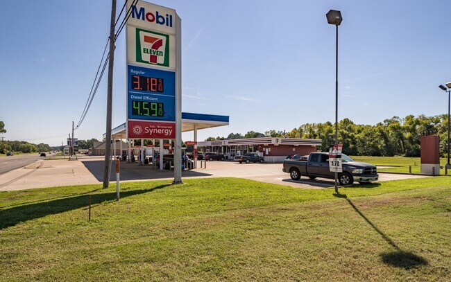
Property Record
820 State Highway 31 E, Chandler, TX 75758

Property Detail
820 State Highway 31 E
0799-2890-0000-12
AB 799 S WEISS SUR, TR 289
Commercialnec
HENDERSON
B and X Area of moderate flood hazard, usually the area between the limits of the 100-year and 500-year floods.
Texas
2024
1.08 AC
2025
Henderson County
950102
Dallas/Ft Worth
4,312 SF
Athens, TX
NEARBY LISTINGS FOR SALE OR LEASE
DEMOGRAPHICS near 820 State Highway 31 E
1 mile
3 mile
5 mile
2025 Total Population
1,895
4,903
10,791
2030 Population
1,925
5,058
11,286
Pop Growth 2025-2030
+ 1.58%
+ 3.16%
+ 4.59%
Average Age
44
43
42
2025 Total Households
762
1,946
4,158
HH Growth 2025-2030
+ 1.44%
+ 2.93%
+ 4.26%
Median Household Inc
$55,499
$57,317
$62,190
Avg Household Size
2.40
2.40
2.50
2025 Avg HH Vehicles
2.00
2.00
2.00
Median Home Value
$226,000
$232,385
$221,327
Median Year Built
1989
1987
1986
Nearby Places
Map Layers
Map Styles
 Street
 Aerial
Layers
 Traffic
 Biking
Places
Listings with unknown addresses are not visible on the map
- Restaurants
- Banks
- Shops
- Fitness
- Groceries
PUBLIC TRANSPORTATION
AIRPORT
Tyler Pounds Regional
Drive
Walk
Distance
Tyler Pounds Regional
15 min
8.2 mi
Freight Ports
Port of Shreveport
Drive
Walk
Distance
Port of Shreveport
134 min
117.0 mi
SALE & LEASE HISTORY
LISTING DATE
SALE/LEASE

Sep 27, 2022
For Sale
May 27, 2025
For Sale
Jan 27, 2025
For Sale
Apr 28, 2023
For Sale
Nearby Properties
Address
Land Use
TOTAL SIZE
Lot Size
Zoning
Address
Land Use
TOTAL SIZE
Lot Size
Zoning
61,280 SF
40.60 AC
Address
Land Use
TOTAL SIZE
Lot Size
Zoning
1,238.79 AC
Address
Land Use
TOTAL SIZE
Lot Size
Zoning
39,582 SF
5.44 AC
Address
Land Use
TOTAL SIZE
Lot Size
Zoning
34,422 SF
4.21 AC
Address
Land Use
TOTAL SIZE
Lot Size
Zoning
17,640 SF
3.54 AC
Address
Land Use
TOTAL SIZE
Lot Size
Zoning
8,960 SF
5.25 AC
Address
Land Use
TOTAL SIZE
Lot Size
Zoning
8,500 SF
1.65 AC
Address
Land Use
TOTAL SIZE
Lot Size
Zoning
1 AC
Address
Land Use
TOTAL SIZE
Lot Size
Zoning
40,334 SF
7 AC
Address
Land Use
TOTAL SIZE
Lot Size
Zoning
331.28 AC
Address
Land Use
TOTAL SIZE
Lot Size
Zoning
6,300 SF
5.72 AC
Address
Land Use
TOTAL SIZE
Lot Size
Zoning
27,640 SF
1.53 AC
Address
Land Use
TOTAL SIZE
Lot Size
Zoning
4,269 SF
3.60 AC
Address
Land Use
TOTAL SIZE
Lot Size
Zoning
40,000 SF
2.84 AC
Address
Land Use
TOTAL SIZE
Lot Size
Zoning
9,451 SF
67.38 AC
Address
Land Use
TOTAL SIZE
Lot Size
Zoning
7,997 SF
6.39 AC
Address
Land Use
TOTAL SIZE
Lot Size
Zoning
199.84 AC
Address
Land Use
TOTAL SIZE
Lot Size
Zoning
18,492 SF
9.03 AC
Address
Land Use
TOTAL SIZE
Lot Size
Zoning
22,958 SF
5.26 AC
Address
Land Use
TOTAL SIZE
Lot Size
Zoning
6.45 AC
Address
Land Use
TOTAL SIZE
Lot Size
Zoning
15,000 SF
3.67 AC
Address
Land Use
TOTAL SIZE
Lot Size
Zoning
10,780 SF
1.81 AC
Address
Land Use
TOTAL SIZE
Lot Size
Zoning
65.12 AC
Address
Land Use
TOTAL SIZE
Lot Size
Zoning
28,680 SF
2.38 AC
Address
Land Use
TOTAL SIZE
Lot Size
Zoning
2,706 SF
0.86 AC
Address
Land Use
TOTAL SIZE
Lot Size
Zoning
19,953 SF
2.14 AC
Address
Land Use
TOTAL SIZE
Lot Size
Zoning
26,028 SF
1.40 AC
Address
Land Use
TOTAL SIZE
Lot Size
Zoning
5,414 SF
28.27 AC
The World's #1 Commercial Real Estate Marketplace
Connect with us
© 2026 CoStar Group
The information above has been obtained from sources believed reliable. While we do not doubt its accuracy we have not verified it and make no guarantee, warranty or representation about it. It is your responsibility to independently confirm its accuracy and completeness. Any projections, opinions, assumptions, or estimates used are for example only and do not represent the current or future performance of the property. The value of this transaction to you depends on tax and other factors which should be evaluated by your tax, financial, and legal advisors. You and your advisors should conduct a careful, independent investigation of the property to determine to your satisfaction the suitability of the property for your needs.