Property Record
820 Victory Rd, Springfield, OH 45504
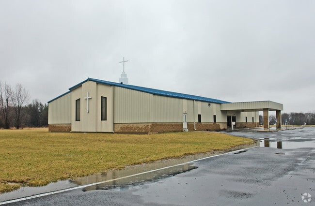

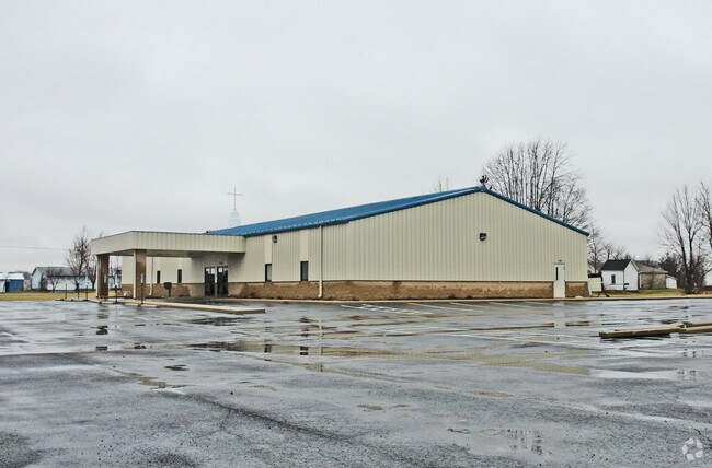
Property Detail
820 Victory Rd
Springfield, OH
W MID PT N W QR (11)
30-00600-02310-1051
Clark
Religious
Ohio
B and X Area of moderate flood hazard, usually the area between the limits of the 100-year and 500-year floods.
51
0
9 AC
2025
Northeast Dayton
002000
Cincinnati/Dayton
NEARBY LISTINGS FOR SALE OR LEASE
-
-
View all Springfield listings for sale on LoopNet.com
DEMOGRAPHICS near 820 Victory Rd
1 mile
3 mile
5 mile
2025 Total Population
1,450
10,104
46,066
2030 Population
1,450
10,159
46,354
Pop Growth 2025-2030
0.00%
+ 0.54%
+ 0.63%
Average Age
44
44
41
2025 Total Households
564
4,108
18,446
HH Growth 2025-2030
0.00%
+ 0.68%
+ 0.68%
Median Household Inc
$85,882
$70,106
$55,248
Avg Household Size
2.60
2.40
2.30
2025 Avg HH Vehicles
2.00
2.00
2.00
Median Home Value
$207,292
$202,754
$176,436
Median Year Built
1967
1968
1956
Nearby Places
Map Layers
Map Styles
 Street
 Aerial
Layers
 Traffic
 Biking
Places
Listings with unknown addresses are not visible on the map
- Restaurants
- Banks
- Shops
- Fitness
- Groceries
PUBLIC TRANSPORTATION
AIRPORT
James M Cox Dayton International
Drive
Walk
Distance
James M Cox Dayton International
36 min
24.4 mi
Freight Ports
Port of Toledo
Drive
Walk
Distance
Port of Toledo
192 min
157.8 mi
Nearby Properties
Address
Land Use
TOTAL SIZE
Lot Size
Zoning
Address
Land Use
TOTAL SIZE
Lot Size
Zoning
17,280 SF
14.32 AC
Address
Land Use
TOTAL SIZE
Lot Size
Zoning
234,478 SF
59.28 AC
Address
Land Use
TOTAL SIZE
Lot Size
Zoning
160,352 SF
22.89 AC
Address
Land Use
TOTAL SIZE
Lot Size
Zoning
225,335 SF
22.73 AC
Address
Land Use
TOTAL SIZE
Lot Size
Zoning
103,589 SF
59.28 AC
Address
Land Use
TOTAL SIZE
Lot Size
Zoning
136,700 SF
14.37 AC
Address
Land Use
TOTAL SIZE
Lot Size
Zoning
111,936 SF
7.04 AC
Address
Land Use
TOTAL SIZE
Lot Size
Zoning
141,891 SF
15.77 AC
R-4
Address
Land Use
TOTAL SIZE
Lot Size
Zoning
812,844 SF
61.98 AC
Address
Land Use
TOTAL SIZE
Lot Size
Zoning
142,045 SF
11.01 AC
Address
Land Use
TOTAL SIZE
Lot Size
Zoning
20,982 SF
19.65 AC
Address
Land Use
TOTAL SIZE
Lot Size
Zoning
66,789 SF
18.25 AC
Address
Land Use
TOTAL SIZE
Lot Size
Zoning
67,153 SF
18.25 AC
Address
Land Use
TOTAL SIZE
Lot Size
Zoning
2.54 AC
Address
Land Use
TOTAL SIZE
Lot Size
Zoning
160,572 SF
13.53 AC
B-1
Address
Land Use
TOTAL SIZE
Lot Size
Zoning
5,886 SF
12.93 AC
Address
Land Use
TOTAL SIZE
Lot Size
Zoning
52,710 SF
1.87 AC
Address
Land Use
TOTAL SIZE
Lot Size
Zoning
42,888 SF
4.02 AC
Address
Land Use
TOTAL SIZE
Lot Size
Zoning
24,440 SF
169.99 AC
A-1
Address
Land Use
TOTAL SIZE
Lot Size
Zoning
148,682 SF
14.32 AC
B-1
Address
Land Use
TOTAL SIZE
Lot Size
Zoning
76,282 SF
6.70 AC
B1
Address
Land Use
TOTAL SIZE
Lot Size
Zoning
29,142 SF
1.31 AC
Address
Land Use
TOTAL SIZE
Lot Size
Zoning
33,348 SF
1.27 AC
Address
Land Use
TOTAL SIZE
Lot Size
Zoning
57,054 SF
2.67 AC
Address
Land Use
TOTAL SIZE
Lot Size
Zoning
83,740 SF
11.81 AC
B-3
Address
Land Use
TOTAL SIZE
Lot Size
Zoning
7.97 AC
Address
Land Use
TOTAL SIZE
Lot Size
Zoning
Address
Land Use
TOTAL SIZE
Lot Size
Zoning
3,048 SF
166.76 AC
Address
Land Use
TOTAL SIZE
Lot Size
Zoning
4,356 SF
201.93 AC
A1
Address
Land Use
TOTAL SIZE
Lot Size
Zoning
102,224 SF
12.10 AC
The World's #1 Commercial Real Estate Marketplace
Connect with us
© 2026 CoStar Group
The information above has been obtained from sources believed reliable. While we do not doubt its accuracy we have not verified it and make no guarantee, warranty or representation about it. It is your responsibility to independently confirm its accuracy and completeness. Any projections, opinions, assumptions, or estimates used are for example only and do not represent the current or future performance of the property. The value of this transaction to you depends on tax and other factors which should be evaluated by your tax, financial, and legal advisors. You and your advisors should conduct a careful, independent investigation of the property to determine to your satisfaction the suitability of the property for your needs.