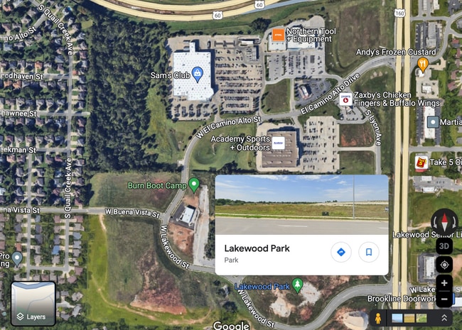
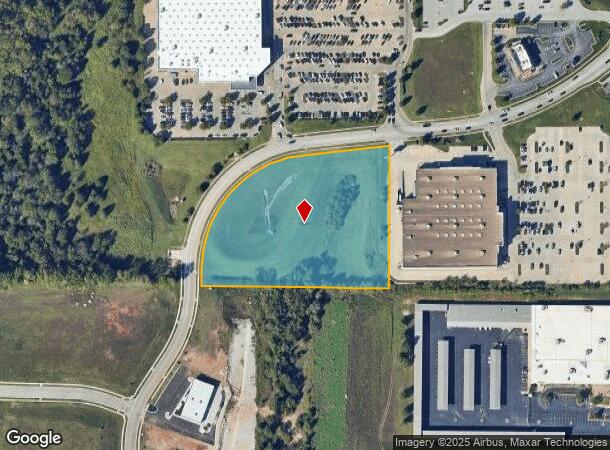
Property Record
W El Camino Uppr Dr, Springfield, MO
This Property Is For Sale
NEARBY LISTINGS FOR SALE OR LEASE
Property Detail
W El Camino Uppr Dr
Springfield, MO
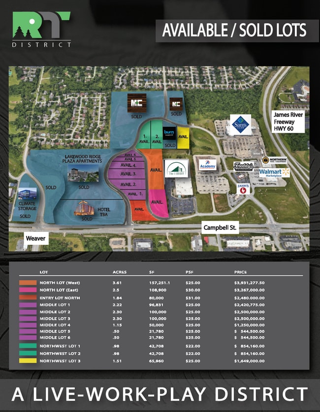
James River Commons
18-14-101-124
JAMES RIVER COMMONS COMMON AREA #3
Commercialacreage
Greene
X
Missouri
29077C0343E
4.92 AC
0
Southwest
2025
Springfield
004103
DEMOGRAPHICS near W El Camino Uppr Dr
1 Mile
3 Mile
5 Mile
2024 Total Population
6,610
62,646
142,890
2029 Population
6,812
64,561
148,835
Pop Growth 2024-2029
+ 3.06%
+ 3.06%
+ 4.16%
Average Age
44
41
40
2024 Total Households
3,110
28,467
63,191
HH Growth 2024-2029
+ 3.22%
+ 3.24%
+ 4.35%
Median Household Inc
$60,084
$56,225
$54,605
Avg Household Size
2.10
2.10
2.10
2024 Avg HH Vehicles
2.00
2.00
2.00
Median Home Value
$228,453
$198,873
$195,322
Median Year Built
1993
1987
1986
Nearby Places
Map Layers
Map Styles
 Street
 Aerial
- Restaurants
- Banks
- Shops
- Fitness
- Groceries
PUBLIC TRANSPORTATION
AIRPORT
Springfield-Branson Ntl
DRIVE
WALK
Distance
Springfield-Branson Ntl
29 min
14.9 mi
Freight Ports
Tulsa Port of Inola
DRIVE
WALK
Distance
Tulsa Port of Inola
192 min
172.5 mi
Nearby Properties
Address
Land Use
TOTAL SIZE
Lot Size
Zoning
Address
Land Use
TOTAL SIZE
Lot Size
Zoning
18.52 AC
INC
Address
Land Use
TOTAL SIZE
Lot Size
Zoning
15.46 AC
Address
Land Use
TOTAL SIZE
Lot Size
Zoning
299,725 SF
18.80 AC
INC
Address
Land Use
TOTAL SIZE
Lot Size
Zoning
284,904 SF
24.38 AC
INC
Address
Land Use
TOTAL SIZE
Lot Size
Zoning
376,072 SF
17.67 AC
INC
Address
Land Use
TOTAL SIZE
Lot Size
Zoning
12.74 AC
Address
Land Use
TOTAL SIZE
Lot Size
Zoning
210,374 SF
24.37 AC
INC
Address
Land Use
TOTAL SIZE
Lot Size
Zoning
180,665 SF
6.36 AC
INC
Address
Land Use
TOTAL SIZE
Lot Size
Zoning
15.46 AC
INC.
Address
Land Use
TOTAL SIZE
Lot Size
Zoning
1.98 AC
INC.
Address
Land Use
TOTAL SIZE
Lot Size
Zoning
105,278 SF
0.54 AC
INC
Address
Land Use
TOTAL SIZE
Lot Size
Zoning
2.31 AC
INC
Address
Land Use
TOTAL SIZE
Lot Size
Zoning
108,880 SF
3.62 AC
INC
Address
Land Use
TOTAL SIZE
Lot Size
Zoning
312,092 SF
38 AC
INC
Address
Land Use
TOTAL SIZE
Lot Size
Zoning
2.76 AC
INC.
Address
Land Use
TOTAL SIZE
Lot Size
Zoning
614,588 SF
57.27 AC
INC
Address
Land Use
TOTAL SIZE
Lot Size
Zoning
26.03 AC
INC
Address
Land Use
TOTAL SIZE
Lot Size
Zoning
51.65 AC
INC
Address
Land Use
TOTAL SIZE
Lot Size
Zoning
211,041 SF
19.13 AC
INC
Address
Land Use
TOTAL SIZE
Lot Size
Zoning
11.56 AC
INC
Address
Land Use
TOTAL SIZE
Lot Size
Zoning
3.43 AC
INC
Address
Land Use
TOTAL SIZE
Lot Size
Zoning
9.82 AC
INC
Address
Land Use
TOTAL SIZE
Lot Size
Zoning
8.24 AC
INC
Address
Land Use
TOTAL SIZE
Lot Size
Zoning
140,147 SF
17.64 AC
INC
Address
Land Use
TOTAL SIZE
Lot Size
Zoning
159,007 SF
16.05 AC
INC
Address
Land Use
TOTAL SIZE
Lot Size
Zoning
42,540 SF
3.63 AC
INC
Address
Land Use
TOTAL SIZE
Lot Size
Zoning
30,400 SF
9.05 AC
INC
Address
Land Use
TOTAL SIZE
Lot Size
Zoning
12.90 AC
INC
Address
Land Use
TOTAL SIZE
Lot Size
Zoning
6.50 AC
INC.
Address
Land Use
TOTAL SIZE
Lot Size
Zoning
70,500 SF
7.20 AC
INC
The World's #1 Commercial Real Estate Marketplace
Connect with us
© 2025 CoStar Group
The information above has been obtained from sources believed reliable. While we do not doubt its accuracy we have not verified it and make no guarantee, warranty or representation about it. It is your responsibility to independently confirm its accuracy and completeness. Any projections, opinions, assumptions, or estimates used are for example only and do not represent the current or future performance of the property. The value of this transaction to you depends on tax and other factors which should be evaluated by your tax, financial, and legal advisors. You and your advisors should conduct a careful, independent investigation of the property to determine to your satisfaction the suitability of the property for your needs.