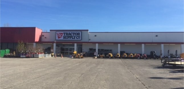
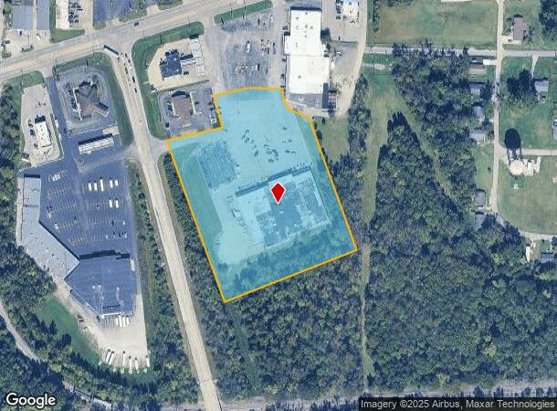
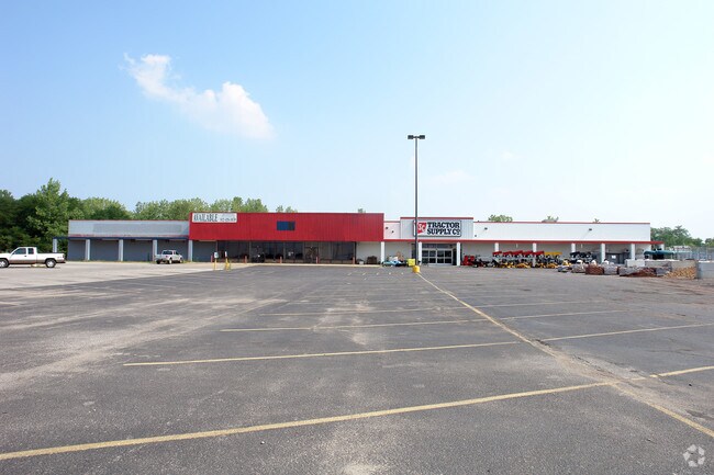
Property Record
820 W Main St, Boonville, IN 47601
NEARBY LISTINGS FOR SALE OR LEASE
Property Detail
820 W Main St
87-09-34-200-102.000-003
PT E 1/2 NE S34 T5 R8 6.31 A.
Wholesaleoutletdiscountstore
Warrick
AE
Indiana
18173C0141D
6.31 AC
2024
Warrick County
2024
Evansville
030602
Evansville, IN-KY
48,566 SF
DEMOGRAPHICS near 820 W Main St
1 Mile
3 Mile
5 Mile
2024 Total Population
4,128
9,534
16,721
2029 Population
4,374
10,055
17,618
Pop Growth 2024-2029
+ 5.96%
+ 5.46%
+ 5.36%
Average Age
41
42
41
2024 Total Households
1,615
3,760
6,496
HH Growth 2024-2029
+ 6.01%
+ 5.51%
+ 5.39%
Median Household Inc
$53,674
$63,630
$72,193
Avg Household Size
2.50
2.40
2.50
2024 Avg HH Vehicles
2.00
2.00
2.00
Median Home Value
$127,701
$158,179
$169,744
Median Year Built
1955
1969
1973
Nearby Places
Map Layers
Map Styles
 Street
 Aerial
- Restaurants
- Banks
- Shops
- Fitness
- Groceries
PUBLIC TRANSPORTATION
AIRPORT
Evansville Regional
DRIVE
WALK
Distance
Evansville Regional
27 min
16.8 mi
Freight Ports
Port of Toledo
DRIVE
WALK
Distance
Port of Toledo
463 min
396.9 mi
SALE & LEASE HISTORY
LISTING DATE
SALE/LEASE

Sep 25, 2016
For Lease
Mar 15, 2017
For Sale
Nearby Properties
Address
Land Use
TOTAL SIZE
Lot Size
Zoning
Address
Land Use
TOTAL SIZE
Lot Size
Zoning
75,712 SF
5.84 AC
Address
Land Use
TOTAL SIZE
Lot Size
Zoning
153,817 SF
19.35 AC
Address
Land Use
TOTAL SIZE
Lot Size
Zoning
84,790 SF
37.15 AC
Address
Land Use
TOTAL SIZE
Lot Size
Zoning
45,459 SF
1.15 AC
Address
Land Use
TOTAL SIZE
Lot Size
Zoning
13,546 SF
3.16 AC
Address
Land Use
TOTAL SIZE
Lot Size
Zoning
45,086 SF
3.19 AC
Address
Land Use
TOTAL SIZE
Lot Size
Zoning
85,334 SF
10.65 AC
Address
Land Use
TOTAL SIZE
Lot Size
Zoning
42,195 SF
3.77 AC
Address
Land Use
TOTAL SIZE
Lot Size
Zoning
10,258 SF
11.25 AC
Address
Land Use
TOTAL SIZE
Lot Size
Zoning
6,725 SF
4.07 AC
Address
Land Use
TOTAL SIZE
Lot Size
Zoning
39,123 SF
9.38 AC
Address
Land Use
TOTAL SIZE
Lot Size
Zoning
20,405 SF
3.92 AC
Address
Land Use
TOTAL SIZE
Lot Size
Zoning
26,932 SF
15.99 AC
Address
Land Use
TOTAL SIZE
Lot Size
Zoning
34,231 SF
1.61 AC
Address
Land Use
TOTAL SIZE
Lot Size
Zoning
7,421 SF
2.27 AC
Address
Land Use
TOTAL SIZE
Lot Size
Zoning
35,344 SF
1.95 AC
Address
Land Use
TOTAL SIZE
Lot Size
Zoning
14,120 SF
7.85 AC
Address
Land Use
TOTAL SIZE
Lot Size
Zoning
7,688 SF
14.45 AC
Address
Land Use
TOTAL SIZE
Lot Size
Zoning
9,216 SF
0.25 AC
Address
Land Use
TOTAL SIZE
Lot Size
Zoning
5,211 SF
1.07 AC
Address
Land Use
TOTAL SIZE
Lot Size
Zoning
12,163 SF
1.87 AC
Address
Land Use
TOTAL SIZE
Lot Size
Zoning
96,108 SF
17 AC
Address
Land Use
TOTAL SIZE
Lot Size
Zoning
18,834 SF
0.50 AC
Address
Land Use
TOTAL SIZE
Lot Size
Zoning
8,624 SF
2.63 AC
Address
Land Use
TOTAL SIZE
Lot Size
Zoning
23,577 SF
0.20 AC
Address
Land Use
TOTAL SIZE
Lot Size
Zoning
69.12 AC
Address
Land Use
TOTAL SIZE
Lot Size
Zoning
15,061 SF
3.39 AC
Address
Land Use
TOTAL SIZE
Lot Size
Zoning
12,080 SF
1.11 AC
Address
Land Use
TOTAL SIZE
Lot Size
Zoning
4,871 SF
0.78 AC
The World's #1 Commercial Real Estate Marketplace
Connect with us
© 2025 CoStar Group
The information above has been obtained from sources believed reliable. While we do not doubt its accuracy we have not verified it and make no guarantee, warranty or representation about it. It is your responsibility to independently confirm its accuracy and completeness. Any projections, opinions, assumptions, or estimates used are for example only and do not represent the current or future performance of the property. The value of this transaction to you depends on tax and other factors which should be evaluated by your tax, financial, and legal advisors. You and your advisors should conduct a careful, independent investigation of the property to determine to your satisfaction the suitability of the property for your needs.