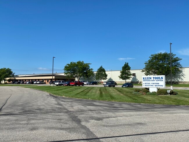
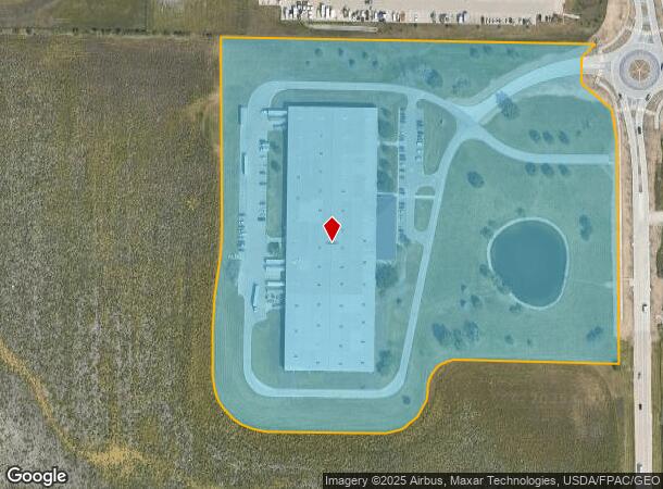
Property Record
8200 6Th St Sw, Cedar Rapids, IA 52404

NEARBY LISTINGS FOR SALE OR LEASE
-
-
-
-
8205 6th Street Southwest-Building 2
Cedar Rapids, IA 52404
$9.25 SF/YR
7,500 - 61,000 SF
Industrial
-
-
-
-
View all Cedar Rapids listings for lease on LoopNet.com
Property Detail
8200 6Th St Sw
19201-76002-00000
P.O.S. #2490 PARCEL A EX RD
Warehouse
Linn
X
Iowa
19113C0420E
23.15 AC
2024
Iowa City/Waterloo
2025
Other Market Areas
010700
Cedar Rapids, IA
176,290 SF
DEMOGRAPHICS near 8200 6Th St Sw
1 Mile
3 Mile
5 Mile
2024 Total Population
123
9,003
42,139
2029 Population
120
9,019
42,308
Pop Growth 2024-2029
(2.44%)
+ 0.18%
+ 0.40%
Average Age
38
33
38
2024 Total Households
45
3,593
17,375
HH Growth 2024-2029
(2.22%)
+ 0.22%
+ 0.41%
Median Household Inc
$94,999
$56,009
$61,548
Avg Household Size
2.70
2.40
2.30
2024 Avg HH Vehicles
2.00
2.00
2.00
Median Home Value
$250,000
$185,098
$170,581
Median Year Built
2002
2001
1980
Nearby Places
Map Layers
Map Styles
 Street
 Aerial
- Restaurants
- Banks
- Shops
- Fitness
- Groceries
PUBLIC TRANSPORTATION
AIRPORT
The Eastern Iowa
DRIVE
WALK
Distance
The Eastern Iowa
9 min
4.1 mi
Freight Ports
Port Milwaukee
DRIVE
WALK
Distance
Port Milwaukee
302 min
253.7 mi
SALE & LEASE HISTORY
LISTING DATE
SALE/LEASE

Sep 25, 2020
For Lease
Jul 30, 2020
For Sale
Nearby Properties
Address
Land Use
TOTAL SIZE
Lot Size
Zoning
Address
Land Use
TOTAL SIZE
Lot Size
Zoning
612,805 SF
21.93 AC
Address
Land Use
TOTAL SIZE
Lot Size
Zoning
269,397 SF
153.19 AC
Address
Land Use
TOTAL SIZE
Lot Size
Zoning
486,932 SF
40.73 AC
Address
Land Use
TOTAL SIZE
Lot Size
Zoning
1,012,084 SF
45.85 AC
Address
Land Use
TOTAL SIZE
Lot Size
Zoning
647,731 SF
127.92 AC
Address
Land Use
TOTAL SIZE
Lot Size
Zoning
937.94 AC
Address
Land Use
TOTAL SIZE
Lot Size
Zoning
103,804 SF
46.29 AC
Address
Land Use
TOTAL SIZE
Lot Size
Zoning
231,824 SF
31.61 AC
Address
Land Use
TOTAL SIZE
Lot Size
Zoning
550,428 SF
78.91 AC
Address
Land Use
TOTAL SIZE
Lot Size
Zoning
142,137 SF
34.61 AC
Address
Land Use
TOTAL SIZE
Lot Size
Zoning
592,459 SF
45.65 AC
Address
Land Use
TOTAL SIZE
Lot Size
Zoning
172,000 SF
168.92 AC
Address
Land Use
TOTAL SIZE
Lot Size
Zoning
218,451 SF
18.74 AC
Address
Land Use
TOTAL SIZE
Lot Size
Zoning
202,762 SF
22.71 AC
Address
Land Use
TOTAL SIZE
Lot Size
Zoning
243,300 SF
22.44 AC
Address
Land Use
TOTAL SIZE
Lot Size
Zoning
907,717 SF
152.19 AC
Address
Land Use
TOTAL SIZE
Lot Size
Zoning
142,780 SF
14.32 AC
Address
Land Use
TOTAL SIZE
Lot Size
Zoning
224,710 SF
22.66 AC
Address
Land Use
TOTAL SIZE
Lot Size
Zoning
350,770 SF
20.88 AC
Address
Land Use
TOTAL SIZE
Lot Size
Zoning
56,924 SF
Address
Land Use
TOTAL SIZE
Lot Size
Zoning
157,850 SF
17.53 AC
Address
Land Use
TOTAL SIZE
Lot Size
Zoning
203,840 SF
18.22 AC
Address
Land Use
TOTAL SIZE
Lot Size
Zoning
205,013 SF
16.44 AC
Address
Land Use
TOTAL SIZE
Lot Size
Zoning
410,000 SF
21.20 AC
Address
Land Use
TOTAL SIZE
Lot Size
Zoning
203,272 SF
17.80 AC
Address
Land Use
TOTAL SIZE
Lot Size
Zoning
30,185 SF
148.88 AC
Address
Land Use
TOTAL SIZE
Lot Size
Zoning
44,520 SF
7.28 AC
Address
Land Use
TOTAL SIZE
Lot Size
Zoning
60,096 SF
4.70 AC
Address
Land Use
TOTAL SIZE
Lot Size
Zoning
175,115 SF
30.13 AC
Address
Land Use
TOTAL SIZE
Lot Size
Zoning
210,000 SF
13.20 AC
The World's #1 Commercial Real Estate Marketplace
Connect with us
© 2026 CoStar Group
The information above has been obtained from sources believed reliable. While we do not doubt its accuracy we have not verified it and make no guarantee, warranty or representation about it. It is your responsibility to independently confirm its accuracy and completeness. Any projections, opinions, assumptions, or estimates used are for example only and do not represent the current or future performance of the property. The value of this transaction to you depends on tax and other factors which should be evaluated by your tax, financial, and legal advisors. You and your advisors should conduct a careful, independent investigation of the property to determine to your satisfaction the suitability of the property for your needs.