Property Record
8200 Broadwell Rd, Cincinnati, OH 45244
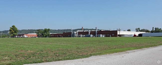

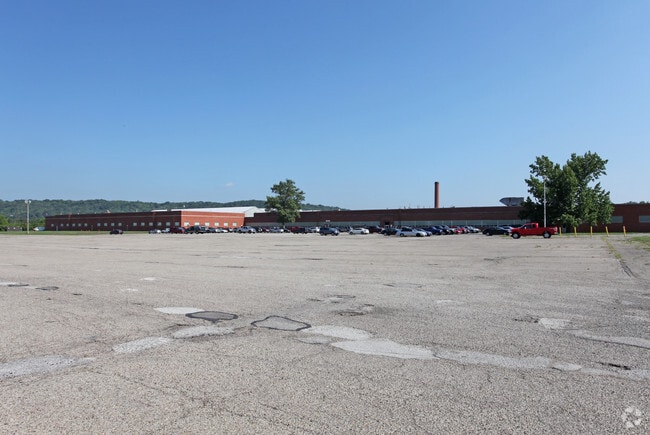

Property Detail
8200 Broadwell Rd
Cincinnati, OH-KY-IN
NS BROADWELL RD 49.2749ACMS 1575&1769 PARS 5-6-15-33-34& PG 170PR3-10-11 CONS
500-0090-0005
HAMILTON
Industrialgeneral
Ohio
B and X Area of moderate flood hazard, usually the area between the limits of the 100-year and 500-year floods.
49.27 AC
2025
East
2025
Cincinnati/Dayton
024901
NEARBY LISTINGS FOR SALE OR LEASE
-
-
View all Cincinnati listings for lease on LoopNet.com
DEMOGRAPHICS near 8200 Broadwell Rd
1 mile
3 mile
5 mile
2025 Total Population
646
28,752
115,379
2030 Population
656
29,237
116,945
Pop Growth 2025-2030
+ 1.55%
+ 1.69%
+ 1.36%
Average Age
41
42
41
2025 Total Households
242
11,358
47,163
HH Growth 2025-2030
+ 1.65%
+ 2.06%
+ 1.60%
Median Household Inc
$68,684
$95,697
$91,197
Avg Household Size
2.60
2.50
2.40
2025 Avg HH Vehicles
2.00
2.00
2.00
Median Home Value
$487,499
$409,773
$335,350
Median Year Built
1965
1975
1973
Nearby Places
Map Layers
Map Styles
 Street
 Aerial
Layers
 Traffic
 Biking
Places
Listings with unknown addresses are not visible on the map
- Restaurants
- Banks
- Shops
- Fitness
- Groceries
PUBLIC TRANSPORTATION
AIRPORT
Cincinnati/Northern Kentucky International
Drive
Walk
Distance
Cincinnati/Northern Kentucky International
49 min
29.7 mi
Freight Ports
Port of Toledo
Drive
Walk
Distance
Port of Toledo
253 min
211.0 mi
SALE & LEASE HISTORY
LISTING DATE
SALE/LEASE

Apr 28, 2025
For Lease
Nearby Properties
Address
Land Use
TOTAL SIZE
Lot Size
Zoning
Address
Land Use
TOTAL SIZE
Lot Size
Zoning
20.01 AC
Address
Land Use
TOTAL SIZE
Lot Size
Zoning
1,205 SF
41.47 AC
Address
Land Use
TOTAL SIZE
Lot Size
Zoning
25.51 AC
Address
Land Use
TOTAL SIZE
Lot Size
Zoning
1,134,029 SF
229.73 AC
Address
Land Use
TOTAL SIZE
Lot Size
Zoning
7.49 AC
Address
Land Use
TOTAL SIZE
Lot Size
Zoning
6.55 AC
Address
Land Use
TOTAL SIZE
Lot Size
Zoning
27.01 AC
Address
Land Use
TOTAL SIZE
Lot Size
Zoning
220,050 SF
33 AC
Address
Land Use
TOTAL SIZE
Lot Size
Zoning
221,360 SF
34.62 AC
Address
Land Use
TOTAL SIZE
Lot Size
Zoning
49.66 AC
Address
Land Use
TOTAL SIZE
Lot Size
Zoning
62,823 SF
8.24 AC
Address
Land Use
TOTAL SIZE
Lot Size
Zoning
9.59 AC
Address
Land Use
TOTAL SIZE
Lot Size
Zoning
75,944 SF
4.09 AC
Address
Land Use
TOTAL SIZE
Lot Size
Zoning
13.89 AC
Address
Land Use
TOTAL SIZE
Lot Size
Zoning
4,800 SF
3.41 AC
Address
Land Use
TOTAL SIZE
Lot Size
Zoning
19,843 SF
4 AC
Address
Land Use
TOTAL SIZE
Lot Size
Zoning
140.32 AC
Address
Land Use
TOTAL SIZE
Lot Size
Zoning
32,024 SF
3.24 AC
Address
Land Use
TOTAL SIZE
Lot Size
Zoning
74,252 SF
20.47 AC
Address
Land Use
TOTAL SIZE
Lot Size
Zoning
36,380 SF
5.45 AC
Address
Land Use
TOTAL SIZE
Lot Size
Zoning
102,891 SF
20.87 AC
Address
Land Use
TOTAL SIZE
Lot Size
Zoning
15,560 SF
37.03 AC
Address
Land Use
TOTAL SIZE
Lot Size
Zoning
14,223 SF
7.22 AC
Address
Land Use
TOTAL SIZE
Lot Size
Zoning
27,957 SF
29.54 AC
Address
Land Use
TOTAL SIZE
Lot Size
Zoning
14.28 AC
DD
Address
Land Use
TOTAL SIZE
Lot Size
Zoning
3,282 SF
1.47 AC
B
Address
Land Use
TOTAL SIZE
Lot Size
Zoning
70.36 AC
A
Address
Land Use
TOTAL SIZE
Lot Size
Zoning
17,485 SF
24.29 AC
Address
Land Use
TOTAL SIZE
Lot Size
Zoning
5.97 AC
EPUDSPI
The World's #1 Commercial Real Estate Marketplace
Connect with us
© 2026 CoStar Group
The information above has been obtained from sources believed reliable. While we do not doubt its accuracy we have not verified it and make no guarantee, warranty or representation about it. It is your responsibility to independently confirm its accuracy and completeness. Any projections, opinions, assumptions, or estimates used are for example only and do not represent the current or future performance of the property. The value of this transaction to you depends on tax and other factors which should be evaluated by your tax, financial, and legal advisors. You and your advisors should conduct a careful, independent investigation of the property to determine to your satisfaction the suitability of the property for your needs.