Property Record
8200 Graphic Dr Ne, Belmont, MI 49306

NEARBY LISTINGS FOR SALE OR LEASE
-
-
View all Belmont listings for sale on LoopNet.com
Property Detail
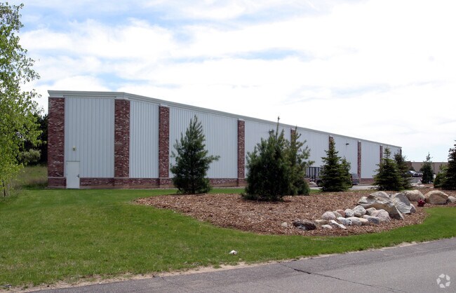
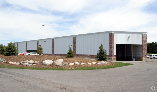
8200 Graphic Dr Ne
41-10-03-152-002
PART OF NWFRL 1/4 COM AT W 1/4 COR TH S 88D 35M 26S E ALONG E&W 1/4 LINE 1300.15 FT TO W 1/8 LINE TH N 0D 34M 50S W ALONG W
Industrialgeneral
Kent
X
Michigan
26081C0301D
2 AC
2024
Outlying Kent County
2025
West Michigan
011102
Grand Rapids-Wyoming-Kentwood, MI
DEMOGRAPHICS near 8200 Graphic Dr Ne
1 Mile
3 Mile
5 Mile
2024 Total Population
1,649
21,842
49,703
2029 Population
1,691
22,150
50,274
Pop Growth 2024-2029
+ 2.55%
+ 1.41%
+ 1.15%
Average Age
38
39
40
2024 Total Households
592
7,871
18,494
HH Growth 2024-2029
+ 2.53%
+ 1.41%
+ 1.14%
Median Household Inc
$110,344
$99,557
$93,324
Avg Household Size
2.70
2.70
2.70
2024 Avg HH Vehicles
2.00
2.00
2.00
Median Home Value
$327,985
$286,451
$284,843
Median Year Built
2007
1991
1989
Nearby Places
Map Layers
Map Styles
 Street
 Aerial
- Restaurants
- Banks
- Shops
- Fitness
- Groceries
PUBLIC TRANSPORTATION
AIRPORT
Gerald R Ford International
DRIVE
WALK
Distance
Gerald R Ford International
35 min
26.0 mi
Nearby Properties
Address
Land Use
TOTAL SIZE
Lot Size
Zoning
Address
Land Use
TOTAL SIZE
Lot Size
Zoning
32.53 AC
Address
Land Use
TOTAL SIZE
Lot Size
Zoning
22.40 AC
Address
Land Use
TOTAL SIZE
Lot Size
Zoning
128,148 SF
42.93 AC
PUD
Address
Land Use
TOTAL SIZE
Lot Size
Zoning
17.30 AC
Address
Land Use
TOTAL SIZE
Lot Size
Zoning
4.51 AC
Address
Land Use
TOTAL SIZE
Lot Size
Zoning
97.71 AC
Address
Land Use
TOTAL SIZE
Lot Size
Zoning
97.84 AC
Address
Land Use
TOTAL SIZE
Lot Size
Zoning
113,165 SF
10.94 AC
R-3
Address
Land Use
TOTAL SIZE
Lot Size
Zoning
74,756 SF
9.86 AC
C-3
Address
Land Use
TOTAL SIZE
Lot Size
Zoning
53.97 AC
Address
Land Use
TOTAL SIZE
Lot Size
Zoning
79.34 AC
Address
Land Use
TOTAL SIZE
Lot Size
Zoning
9.88 AC
Address
Land Use
TOTAL SIZE
Lot Size
Zoning
10.08 AC
Address
Land Use
TOTAL SIZE
Lot Size
Zoning
11.26 AC
Address
Land Use
TOTAL SIZE
Lot Size
Zoning
10.12 AC
Address
Land Use
TOTAL SIZE
Lot Size
Zoning
6.51 AC
Address
Land Use
TOTAL SIZE
Lot Size
Zoning
10.61 AC
Address
Land Use
TOTAL SIZE
Lot Size
Zoning
44.69 AC
Address
Land Use
TOTAL SIZE
Lot Size
Zoning
18,630 SF
1.84 AC
C2
Address
Land Use
TOTAL SIZE
Lot Size
Zoning
17.70 AC
Address
Land Use
TOTAL SIZE
Lot Size
Zoning
Address
Land Use
TOTAL SIZE
Lot Size
Zoning
2.28 AC
Address
Land Use
TOTAL SIZE
Lot Size
Zoning
3.62 AC
Address
Land Use
TOTAL SIZE
Lot Size
Zoning
110.94 AC
Address
Land Use
TOTAL SIZE
Lot Size
Zoning
257.69 AC
Address
Land Use
TOTAL SIZE
Lot Size
Zoning
2.96 AC
Address
Land Use
TOTAL SIZE
Lot Size
Zoning
Address
Land Use
TOTAL SIZE
Lot Size
Zoning
3.15 AC
Address
Land Use
TOTAL SIZE
Lot Size
Zoning
8.72 AC
Address
Land Use
TOTAL SIZE
Lot Size
Zoning
1,548 SF
49.71 AC
The World's #1 Commercial Real Estate Marketplace
Connect with us
© 2026 CoStar Group
The information above has been obtained from sources believed reliable. While we do not doubt its accuracy we have not verified it and make no guarantee, warranty or representation about it. It is your responsibility to independently confirm its accuracy and completeness. Any projections, opinions, assumptions, or estimates used are for example only and do not represent the current or future performance of the property. The value of this transaction to you depends on tax and other factors which should be evaluated by your tax, financial, and legal advisors. You and your advisors should conduct a careful, independent investigation of the property to determine to your satisfaction the suitability of the property for your needs.