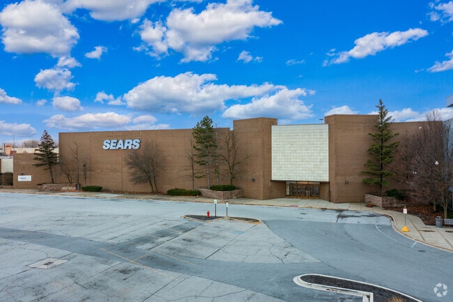
Property Record
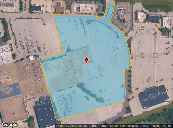
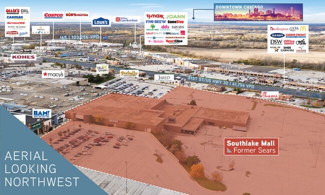
8200 Iowa St, Hobart, IN 46342
NEARBY LISTINGS FOR SALE OR LEASE
Property Detail
8200 Iowa St
45-12-23-326-004.000-046
PT SW & W1/2 W1/2 SE. AND PARCEL 184X239.19FT S.23 T.35 R.8 17.500 AC. *
Departmentstore
Lake
X
Indiana
18089C0256E
1
2024
17.50 AC
2025
Indiana
042200
Chicago
225,145 SF
Chicago-Naperville-Elgin, IL-IN
DEMOGRAPHICS near 8200 Iowa St
1 Mile
3 Mile
5 Mile
2024 Total Population
1,622
22,952
91,956
2029 Population
1,612
22,966
92,445
Pop Growth 2024-2029
(0.62%)
+ 0.06%
+ 0.53%
Average Age
39
43
41
2024 Total Households
857
10,056
36,489
HH Growth 2024-2029
(0.70%)
+ 0.11%
+ 0.48%
Median Household Inc
$65,233
$62,868
$68,894
Avg Household Size
1.90
2.20
2.40
2024 Avg HH Vehicles
1.00
2.00
2.00
Median Home Value
$234,375
$184,703
$202,288
Median Year Built
1991
1990
1977
Nearby Places
Map Layers
Map Styles
 Street
 Aerial
- Restaurants
- Banks
- Shops
- Fitness
- Groceries
SALE & LEASE HISTORY
LISTING DATE
SALE/LEASE

Sep 16, 2020
For Sale
Jan 05, 2023
For Sale
Nearby Properties
Address
Land Use
TOTAL SIZE
Lot Size
Zoning
Address
Land Use
TOTAL SIZE
Lot Size
Zoning
1,002,000 SF
60.96 AC
Address
Land Use
TOTAL SIZE
Lot Size
Zoning
722,810 SF
64.65 AC
R33
Address
Land Use
TOTAL SIZE
Lot Size
Zoning
713,953 SF
39.61 AC
Address
Land Use
TOTAL SIZE
Lot Size
Zoning
552,100 SF
49.14 AC
Address
Land Use
TOTAL SIZE
Lot Size
Zoning
655,916 SF
46.27 AC
Address
Land Use
TOTAL SIZE
Lot Size
Zoning
598,983 SF
88 AC
Address
Land Use
TOTAL SIZE
Lot Size
Zoning
427,836 SF
54.72 AC
Address
Land Use
TOTAL SIZE
Lot Size
Zoning
590,274 SF
48.18 AC
Address
Land Use
TOTAL SIZE
Lot Size
Zoning
536,896 SF
20.08 AC
Address
Land Use
TOTAL SIZE
Lot Size
Zoning
377,878 SF
21.58 AC
Address
Land Use
TOTAL SIZE
Lot Size
Zoning
365,748 SF
17.44 AC
R33
Address
Land Use
TOTAL SIZE
Lot Size
Zoning
623,283 SF
44.38 AC
Address
Land Use
TOTAL SIZE
Lot Size
Zoning
276,540 SF
21.16 AC
Address
Land Use
TOTAL SIZE
Lot Size
Zoning
359,024 SF
43 AC
Address
Land Use
TOTAL SIZE
Lot Size
Zoning
263,968 SF
27.86 AC
Address
Land Use
TOTAL SIZE
Lot Size
Zoning
111,453 SF
15.21 AC
Address
Land Use
TOTAL SIZE
Lot Size
Zoning
291,060 SF
37.07 AC
Address
Land Use
TOTAL SIZE
Lot Size
Zoning
258,560 SF
17.30 AC
Address
Land Use
TOTAL SIZE
Lot Size
Zoning
236,904 SF
11.30 AC
R33
Address
Land Use
TOTAL SIZE
Lot Size
Zoning
159,548 SF
16.18 AC
Address
Land Use
TOTAL SIZE
Lot Size
Zoning
177,628 SF
12.95 AC
R3
Address
Land Use
TOTAL SIZE
Lot Size
Zoning
237,204 SF
28.82 AC
Address
Land Use
TOTAL SIZE
Lot Size
Zoning
194,027 SF
13.55 AC
Address
Land Use
TOTAL SIZE
Lot Size
Zoning
171,546 SF
19 AC
Address
Land Use
TOTAL SIZE
Lot Size
Zoning
143,060 SF
33.82 AC
Address
Land Use
TOTAL SIZE
Lot Size
Zoning
108,193 SF
2.42 AC
Address
Land Use
TOTAL SIZE
Lot Size
Zoning
329,040 SF
30.19 AC
Address
Land Use
TOTAL SIZE
Lot Size
Zoning
190,352 SF
12.36 AC
Address
Land Use
TOTAL SIZE
Lot Size
Zoning
126,603 SF
8.81 AC
Address
Land Use
TOTAL SIZE
Lot Size
Zoning
92,823 SF
8.56 AC
The World's #1 Commercial Real Estate Marketplace
Connect with us
© 2026 CoStar Group
The information above has been obtained from sources believed reliable. While we do not doubt its accuracy we have not verified it and make no guarantee, warranty or representation about it. It is your responsibility to independently confirm its accuracy and completeness. Any projections, opinions, assumptions, or estimates used are for example only and do not represent the current or future performance of the property. The value of this transaction to you depends on tax and other factors which should be evaluated by your tax, financial, and legal advisors. You and your advisors should conduct a careful, independent investigation of the property to determine to your satisfaction the suitability of the property for your needs.