Property Record
8200 Macomb St, Grosse Ile, MI 48138
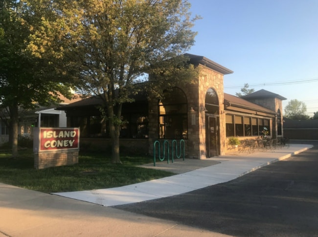


This Property Is For Sale
NEARBY LISTINGS FOR SALE OR LEASE
Property Detail
8200 Macomb St
Detroit-Warren-Dearborn, MI
Horace Grays
73-028-01-0022-002
552D22B W 50 FT OF LOT 22 EAST SIDE HORACE GRAYS SUB PC 552 L4 P39 WCR
Commercialacreage
Wayne
X
Michigan
26163C0419F
22
2025
0.18 AC
2025
Downriver South
596200
Detroit
DEMOGRAPHICS near 8200 Macomb St
1 mile
3 mile
5 mile
2024 Total Population
3,328
18,792
60,984
2029 Population
3,203
18,031
58,435
Pop Growth 2024-2029
(3.76%)
(4.05%)
(4.18%)
Average Age
46
46
44
2024 Total Households
1,364
8,136
26,334
HH Growth 2024-2029
(3.74%)
(4.09%)
(4.22%)
Median Household Inc
$120,454
$93,176
$75,232
Avg Household Size
2.40
2.30
2.30
2024 Avg HH Vehicles
2.00
2.00
2.00
Median Home Value
$360,714
$261,514
$198,062
Median Year Built
1975
1966
1967
Nearby Places
Map Layers
Map Styles
 Street
 Aerial
Transit
 Traffic
 Biking
Places
Listings with unknown addresses are not visible on the map
- Restaurants
- Banks
- Shops
- Fitness
- Groceries
PUBLIC TRANSPORTATION
AIRPORT
Detroit Metro Wayne County
Drive
Walk
Distance
Detroit Metro Wayne County
36 min
19.1 mi
Windsor International
Drive
Walk
Distance
Windsor International
56 min
33.5 mi
Freight Ports
Drive
Walk
Distance
62 min
44.9 mi
Nearby Properties
Address
Land Use
TOTAL SIZE
Lot Size
Zoning
Address
Land Use
TOTAL SIZE
Lot Size
Zoning
2,651,867 SF
137.23 AC
I-3
Address
Land Use
TOTAL SIZE
Lot Size
Zoning
155,600 SF
83.84 AC
R1
Address
Land Use
TOTAL SIZE
Lot Size
Zoning
2,160 SF
334.88 AC
I1
Address
Land Use
TOTAL SIZE
Lot Size
Zoning
143,496 SF
3.73 AC
RM-2
Address
Land Use
TOTAL SIZE
Lot Size
Zoning
58,149 SF
11.40 AC
B2-COM
Address
Land Use
TOTAL SIZE
Lot Size
Zoning
62,039 SF
Address
Land Use
TOTAL SIZE
Lot Size
Zoning
172,969 SF
15.30 AC
RM-1
Address
Land Use
TOTAL SIZE
Lot Size
Zoning
40,136 SF
42.97 AC
R-1-D
Address
Land Use
TOTAL SIZE
Lot Size
Zoning
14,377 SF
2.58 AC
R-1-A
Address
Land Use
TOTAL SIZE
Lot Size
Zoning
8,325 SF
3.15 AC
R-1-A
Address
Land Use
TOTAL SIZE
Lot Size
Zoning
9,584 SF
4.69 AC
R-1-A
Address
Land Use
TOTAL SIZE
Lot Size
Zoning
50,880 SF
4.87 AC
R-1-F
Address
Land Use
TOTAL SIZE
Lot Size
Zoning
133.65 AC
MU REDEV
Address
Land Use
TOTAL SIZE
Lot Size
Zoning
354,969 SF
23.78 AC
I2
Address
Land Use
TOTAL SIZE
Lot Size
Zoning
35,518 SF
1.21 AC
B2
Address
Land Use
TOTAL SIZE
Lot Size
Zoning
3,500 SF
106.18 AC
R-1-D
Address
Land Use
TOTAL SIZE
Lot Size
Zoning
49,878 SF
3.98 AC
RM-1
Address
Land Use
TOTAL SIZE
Lot Size
Zoning
109.60 AC
R-1-D
Address
Land Use
TOTAL SIZE
Lot Size
Zoning
8,849 SF
3.13 AC
R-1-A
Address
Land Use
TOTAL SIZE
Lot Size
Zoning
48,436 SF
3.42 AC
RM-1
Address
Land Use
TOTAL SIZE
Lot Size
Zoning
103,950 SF
5.04 AC
R1-ONE
Address
Land Use
TOTAL SIZE
Lot Size
Zoning
9,988 SF
3.01 AC
R-1-A
Address
Land Use
TOTAL SIZE
Lot Size
Zoning
8,429 SF
0.92 AC
R-1-A
Address
Land Use
TOTAL SIZE
Lot Size
Zoning
9,876 SF
Address
Land Use
TOTAL SIZE
Lot Size
Zoning
62,480 SF
5.81 AC
RM-1
Address
Land Use
TOTAL SIZE
Lot Size
Zoning
44,172 SF
2.66 AC
RM-1
Address
Land Use
TOTAL SIZE
Lot Size
Zoning
6,091 SF
2.35 AC
R-1-B
Address
Land Use
TOTAL SIZE
Lot Size
Zoning
6,931 SF
1.39 AC
R-1-A
Address
Land Use
TOTAL SIZE
Lot Size
Zoning
8,703 SF
1.32 AC
R-1-A
Address
Land Use
TOTAL SIZE
Lot Size
Zoning
7,060 SF
1.28 AC
R-1-A
The World's #1 Commercial Real Estate Marketplace
Connect with us
© 2026 CoStar Group
The information above has been obtained from sources believed reliable. While we do not doubt its accuracy we have not verified it and make no guarantee, warranty or representation about it. It is your responsibility to independently confirm its accuracy and completeness. Any projections, opinions, assumptions, or estimates used are for example only and do not represent the current or future performance of the property. The value of this transaction to you depends on tax and other factors which should be evaluated by your tax, financial, and legal advisors. You and your advisors should conduct a careful, independent investigation of the property to determine to your satisfaction the suitability of the property for your needs.