Property Record
8200 Schrade Rd, Rowlett, TX 75088
This Property Is For Sale
NEARBY LISTINGS FOR SALE OR LEASE
Property Detail
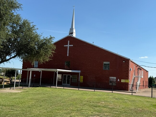
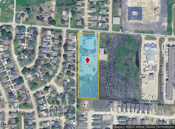
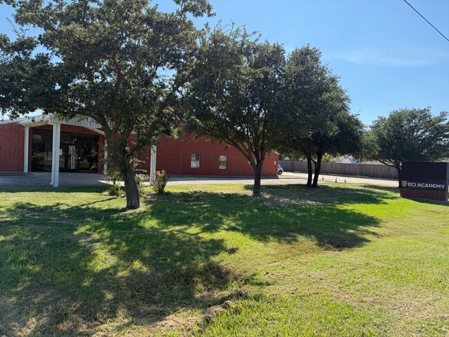
8200 Schrade Rd
Dallas-Fort Worth-Arlington, TX
Cornerstone Church
440012200101R0000
CORNERSTONE CHURCH BLK 1 LT 1R ACS 2.00 TE ACCT 440012200101RTE00 INT201900094940 DD04152019 CO-DC 0012200101R00 2CW00122001
Religious
Dallas
X
Texas
48113C0245K
1r
0
2 AC
2025
Garland
018134
Dallas/Ft Worth
7,345 SF
DEMOGRAPHICS near 8200 Schrade Rd
1 Mile
3 Mile
5 Mile
2024 Total Population
10,738
51,389
141,353
2029 Population
11,927
56,488
160,579
Pop Growth 2024-2029
+ 11.07%
+ 9.92%
+ 13.60%
Average Age
39
40
39
2024 Total Households
3,641
18,835
49,699
HH Growth 2024-2029
+ 11.07%
+ 10.76%
+ 14.22%
Median Household Inc
$95,440
$99,377
$101,626
Avg Household Size
2.90
2.70
2.80
2024 Avg HH Vehicles
2.00
2.00
2.00
Median Home Value
$263,646
$277,531
$287,300
Median Year Built
1992
1994
1995
Nearby Places
- Restaurants
- Banks
- Shops
- Fitness
- Groceries
PUBLIC TRANSPORTATION
AIRPORT
Dallas Love Field
DRIVE
WALK
Distance
Dallas Love Field
39 min
24.8 mi
Dallas-Fort Worth International
DRIVE
WALK
Distance
Dallas-Fort Worth International
51 min
41.5 mi
Freight Ports
Port of Shreveport
DRIVE
WALK
Distance
Port of Shreveport
213 min
194.4 mi
Nearby Properties
Address
Land Use
TOTAL SIZE
Lot Size
Zoning
Address
Land Use
TOTAL SIZE
Lot Size
Zoning
559,567 SF
10.85 AC
Z80
Address
Land Use
TOTAL SIZE
Lot Size
Zoning
252,909 SF
11.73 AC
Address
Land Use
TOTAL SIZE
Lot Size
Zoning
283,096 SF
10.18 AC
Z80
Address
Land Use
TOTAL SIZE
Lot Size
Zoning
454,141 SF
4.86 AC
Address
Land Use
TOTAL SIZE
Lot Size
Zoning
260,782 SF
16.30 AC
Z77
Address
Land Use
TOTAL SIZE
Lot Size
Zoning
228,458 SF
5.56 AC
Z236
Address
Land Use
TOTAL SIZE
Lot Size
Zoning
427,231 SF
9.96 AC
Z38
Address
Land Use
TOTAL SIZE
Lot Size
Zoning
313,217 SF
3.61 AC
Z205
Address
Land Use
TOTAL SIZE
Lot Size
Zoning
282,628 SF
4.03 AC
Address
Land Use
TOTAL SIZE
Lot Size
Zoning
710,600 SF
3.91 AC
Z80
Address
Land Use
TOTAL SIZE
Lot Size
Zoning
178,125 SF
10.50 AC
Z77
Address
Land Use
TOTAL SIZE
Lot Size
Zoning
495,735 SF
2.92 AC
Z80
Address
Land Use
TOTAL SIZE
Lot Size
Zoning
138,183 SF
4.76 AC
Z80
Address
Land Use
TOTAL SIZE
Lot Size
Zoning
144,725 SF
12.89 AC
Address
Land Use
TOTAL SIZE
Lot Size
Zoning
227,296 SF
2.14 AC
Address
Land Use
TOTAL SIZE
Lot Size
Zoning
196,981 SF
8.92 AC
Address
Land Use
TOTAL SIZE
Lot Size
Zoning
43,600 SF
62.86 AC
Z306
Address
Land Use
TOTAL SIZE
Lot Size
Zoning
223,216 SF
13.79 AC
Z239
Address
Land Use
TOTAL SIZE
Lot Size
Zoning
261,000 SF
1 AC
Z318
Address
Land Use
TOTAL SIZE
Lot Size
Zoning
244,338 SF
4.44 AC
Address
Land Use
TOTAL SIZE
Lot Size
Zoning
108,429 SF
2.06 AC
Address
Land Use
TOTAL SIZE
Lot Size
Zoning
271,051 SF
10.28 AC
Z01
Address
Land Use
TOTAL SIZE
Lot Size
Zoning
99,800 SF
10.10 AC
C
Address
Land Use
TOTAL SIZE
Lot Size
Zoning
43.27 AC
Z80
Address
Land Use
TOTAL SIZE
Lot Size
Zoning
92,413 SF
4.98 AC
Z85
Address
Land Use
TOTAL SIZE
Lot Size
Zoning
151,893 SF
5.40 AC
Z308
Address
Land Use
TOTAL SIZE
Lot Size
Zoning
82,847 SF
4.87 AC
Z236
Address
Land Use
TOTAL SIZE
Lot Size
Zoning
78,017 SF
1.75 AC
Z236
Address
Land Use
TOTAL SIZE
Lot Size
Zoning
115,665 SF
6.79 AC
Z239
Address
Land Use
TOTAL SIZE
Lot Size
Zoning
52,797 SF
5.41 AC
Z92
The World's #1 Commercial Real Estate Marketplace
Connect with us
© 2025 CoStar Group
The information above has been obtained from sources believed reliable. While we do not doubt its accuracy we have not verified it and make no guarantee, warranty or representation about it. It is your responsibility to independently confirm its accuracy and completeness. Any projections, opinions, assumptions, or estimates used are for example only and do not represent the current or future performance of the property. The value of this transaction to you depends on tax and other factors which should be evaluated by your tax, financial, and legal advisors. You and your advisors should conduct a careful, independent investigation of the property to determine to your satisfaction the suitability of the property for your needs.