Property Record
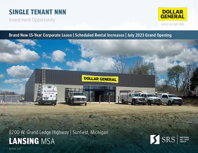
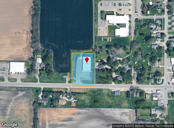
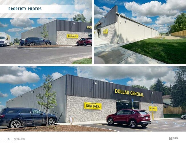
8200 W Grand Ledge Hwy, Sunfield, MI 48890
This Property Is For Sale
NEARBY LISTINGS FOR SALE OR LEASE
-
-
View all Sunfield listings for sale on LoopNet.com
Property Detail
8200 W Grand Ledge Hwy
Lansing-East Lansing, MI
COM SE COR SEC 3; N88 23'11"W 720 FT TO POB; N88 23'11"W 235.04 FT; N00 34'15"E 330.05 FT; S89 25'45"E 235.04 FT; S00 34'15"W 330.05 FT TO POB. SEC 3, T4N, R6W, VILLAGE OF SUNFIELD. D 12-16-22 R 12-28-22 (APROVED) SPLIT FROM 011-003-400-003-02 FOR 20
011-003-400-003-03
Eaton
Storebuilding
Michigan
2024
1.78 AC
2025
Outlying Eaton County
020700
West Michigan
10,640 SF
DEMOGRAPHICS near 8200 W Grand Ledge Hwy
1 Mile
3 Mile
5 Mile
2024 Total Population
635
1,615
3,415
2029 Population
631
1,604
3,396
Pop Growth 2024-2029
(0.63%)
(0.68%)
(0.56%)
Average Age
41
41
42
2024 Total Households
247
631
1,335
HH Growth 2024-2029
(0.40%)
(0.63%)
(0.60%)
Median Household Inc
$67,500
$68,881
$70,206
Avg Household Size
2.50
2.50
2.50
2024 Avg HH Vehicles
2.00
2.00
2.00
Median Home Value
$180,120
$179,240
$180,425
Median Year Built
1971
1970
1969
Nearby Places
Map Layers
Map Styles
 Street
 Aerial
- Restaurants
- Banks
- Shops
- Fitness
- Groceries
PUBLIC TRANSPORTATION
AIRPORT
Capital Region International
DRIVE
WALK
Distance
Capital Region International
41 min
25.3 mi
Gerald R Ford International
DRIVE
WALK
Distance
Gerald R Ford International
55 min
40.7 mi
Freight Ports
Port of Toledo
DRIVE
WALK
Distance
Port of Toledo
181 min
148.9 mi
Nearby Properties
Address
Land Use
TOTAL SIZE
Lot Size
Zoning
Address
Land Use
TOTAL SIZE
Lot Size
Zoning
117,578 SF
19.90 AC
I
Address
Land Use
TOTAL SIZE
Lot Size
Zoning
9,830 SF
5.17 AC
Address
Land Use
TOTAL SIZE
Lot Size
Zoning
33,378 SF
68.25 AC
I
Address
Land Use
TOTAL SIZE
Lot Size
Zoning
60,148 SF
12.29 AC
Address
Land Use
TOTAL SIZE
Lot Size
Zoning
1,800 SF
99.51 AC
LA
Address
Land Use
TOTAL SIZE
Lot Size
Zoning
3,384 SF
4.95 AC
LA
Address
Land Use
TOTAL SIZE
Lot Size
Zoning
4,028 SF
71.42 AC
LA
Address
Land Use
TOTAL SIZE
Lot Size
Zoning
5,034 SF
1.78 AC
LA
Address
Land Use
TOTAL SIZE
Lot Size
Zoning
159.19 AC
Address
Land Use
TOTAL SIZE
Lot Size
Zoning
1,613 SF
129 AC
LA
Address
Land Use
TOTAL SIZE
Lot Size
Zoning
14,040 SF
9.20 AC
RES-R1
Address
Land Use
TOTAL SIZE
Lot Size
Zoning
137.32 AC
Address
Land Use
TOTAL SIZE
Lot Size
Zoning
5,186 SF
1.20 AC
LA
Address
Land Use
TOTAL SIZE
Lot Size
Zoning
Address
Land Use
TOTAL SIZE
Lot Size
Zoning
156.15 AC
Address
Land Use
TOTAL SIZE
Lot Size
Zoning
154 AC
Address
Land Use
TOTAL SIZE
Lot Size
Zoning
4,892 SF
1.17 AC
LA
Address
Land Use
TOTAL SIZE
Lot Size
Zoning
156.25 AC
Address
Land Use
TOTAL SIZE
Lot Size
Zoning
2,160 SF
76.51 AC
LA
Address
Land Use
TOTAL SIZE
Lot Size
Zoning
2,944 SF
123 AC
LA
Address
Land Use
TOTAL SIZE
Lot Size
Zoning
1,981 SF
118 AC
LA
Address
Land Use
TOTAL SIZE
Lot Size
Zoning
1,914 SF
120 AC
LA
Address
Land Use
TOTAL SIZE
Lot Size
Zoning
72.72 AC
LA
Address
Land Use
TOTAL SIZE
Lot Size
Zoning
1,695 SF
79.24 AC
LA
Address
Land Use
TOTAL SIZE
Lot Size
Zoning
3,121 SF
80 AC
LA
Address
Land Use
TOTAL SIZE
Lot Size
Zoning
1,791 SF
74.49 AC
LA
Address
Land Use
TOTAL SIZE
Lot Size
Zoning
2,016 SF
58.26 AC
LA
Address
Land Use
TOTAL SIZE
Lot Size
Zoning
Address
Land Use
TOTAL SIZE
Lot Size
Zoning
119.79 AC
The World's #1 Commercial Real Estate Marketplace
Connect with us
© 2025 CoStar Group
The information above has been obtained from sources believed reliable. While we do not doubt its accuracy we have not verified it and make no guarantee, warranty or representation about it. It is your responsibility to independently confirm its accuracy and completeness. Any projections, opinions, assumptions, or estimates used are for example only and do not represent the current or future performance of the property. The value of this transaction to you depends on tax and other factors which should be evaluated by your tax, financial, and legal advisors. You and your advisors should conduct a careful, independent investigation of the property to determine to your satisfaction the suitability of the property for your needs.