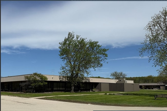
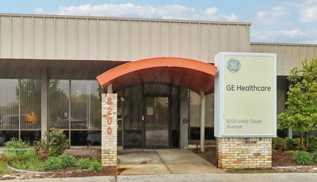
Property Record
8200 W Tower Ave, Milwaukee, WI 53223

Current Lease Availabilities
NEARBY LISTINGS FOR SALE OR LEASE
Property Detail
8200 W Tower Ave
070-0003-110-5
Certified Survey Map No 2184
Warehouse
SLIDE 745 PL 1314-1317 DOC 4793431
X
Milwaukee
55089C0245G
Wisconsin
2024
19.67 AC
2024
Milwaukee NW
000102
Milwaukee/Madison
297,894 SF
Milwaukee-Waukesha-West Allis, WI
DEMOGRAPHICS near 8200 W Tower Ave
1 Mile
3 Mile
5 Mile
2024 Total Population
4,526
60,601
173,687
2029 Population
4,396
59,412
171,871
Pop Growth 2024-2029
(2.87%)
(1.96%)
(1.05%)
Average Age
40
38
38
2024 Total Households
1,945
23,927
68,474
HH Growth 2024-2029
(3.14%)
(2.10%)
(1.09%)
Median Household Inc
$48,043
$56,259
$57,721
Avg Household Size
2.20
2.40
2.50
2024 Avg HH Vehicles
1.00
2.00
2.00
Median Home Value
$130,025
$167,104
$196,192
Median Year Built
1975
1971
1965
Nearby Places
Map Layers
Map Styles
 Street
 Aerial
- Restaurants
- Banks
- Shops
- Fitness
- Groceries
PUBLIC TRANSPORTATION
AIRPORT
General Mitchell International
DRIVE
WALK
Distance
General Mitchell International
38 min
20.8 mi
Freight Ports
Port Milwaukee
DRIVE
WALK
Distance
Port Milwaukee
30 min
16.7 mi
Nearby Properties
Address
Land Use
TOTAL SIZE
Lot Size
Zoning
Address
Land Use
TOTAL SIZE
Lot Size
Zoning
Address
Land Use
TOTAL SIZE
Lot Size
Zoning
33.49 AC
TL
Address
Land Use
TOTAL SIZE
Lot Size
Zoning
391,696 SF
36.33 AC
PD
Address
Land Use
TOTAL SIZE
Lot Size
Zoning
21.58 AC
RESIDENTIA
Address
Land Use
TOTAL SIZE
Lot Size
Zoning
530,458 SF
26.32 AC
Address
Land Use
TOTAL SIZE
Lot Size
Zoning
197,426 SF
26.34 AC
PD
Address
Land Use
TOTAL SIZE
Lot Size
Zoning
206,529 SF
7.88 AC
PD
Address
Land Use
TOTAL SIZE
Lot Size
Zoning
13,717 SF
21.84 AC
IL1
Address
Land Use
TOTAL SIZE
Lot Size
Zoning
292,944 SF
17.32 AC
Address
Land Use
TOTAL SIZE
Lot Size
Zoning
245,266 SF
18.11 AC
PD
Address
Land Use
TOTAL SIZE
Lot Size
Zoning
298,666 SF
5.09 AC
PD
Address
Land Use
TOTAL SIZE
Lot Size
Zoning
209,138 SF
14.70 AC
Address
Land Use
TOTAL SIZE
Lot Size
Zoning
Address
Land Use
TOTAL SIZE
Lot Size
Zoning
326,619 SF
30.69 AC
PD
Address
Land Use
TOTAL SIZE
Lot Size
Zoning
160,000 SF
12.48 AC
Address
Land Use
TOTAL SIZE
Lot Size
Zoning
12.49 AC
TL
Address
Land Use
TOTAL SIZE
Lot Size
Zoning
241,880 SF
17.39 AC
Address
Land Use
TOTAL SIZE
Lot Size
Zoning
104,365 SF
9.85 AC
PD
Address
Land Use
TOTAL SIZE
Lot Size
Zoning
4.70 AC
Address
Land Use
TOTAL SIZE
Lot Size
Zoning
427 SF
35.16 AC
IL1
Address
Land Use
TOTAL SIZE
Lot Size
Zoning
4.26 AC
Address
Land Use
TOTAL SIZE
Lot Size
Zoning
419,659 SF
33.55 AC
IL1
Address
Land Use
TOTAL SIZE
Lot Size
Zoning
140,757 SF
19.08 AC
PD
Address
Land Use
TOTAL SIZE
Lot Size
Zoning
93.72 AC
PK
Address
Land Use
TOTAL SIZE
Lot Size
Zoning
136,544 SF
11.32 AC
Address
Land Use
TOTAL SIZE
Lot Size
Zoning
25.77 AC
Address
Land Use
TOTAL SIZE
Lot Size
Zoning
Address
Land Use
TOTAL SIZE
Lot Size
Zoning
21,516 SF
11.86 AC
IL1
Address
Land Use
TOTAL SIZE
Lot Size
Zoning
364,373 SF
61.40 AC
IL1
Address
Land Use
TOTAL SIZE
Lot Size
Zoning
The World's #1 Commercial Real Estate Marketplace
Connect with us
© 2026 CoStar Group
The information above has been obtained from sources believed reliable. While we do not doubt its accuracy we have not verified it and make no guarantee, warranty or representation about it. It is your responsibility to independently confirm its accuracy and completeness. Any projections, opinions, assumptions, or estimates used are for example only and do not represent the current or future performance of the property. The value of this transaction to you depends on tax and other factors which should be evaluated by your tax, financial, and legal advisors. You and your advisors should conduct a careful, independent investigation of the property to determine to your satisfaction the suitability of the property for your needs.