Property Record
8201 Healthcare Loop, Charlotte, NC 28215
NEARBY LISTINGS FOR SALE OR LEASE
Property Detail
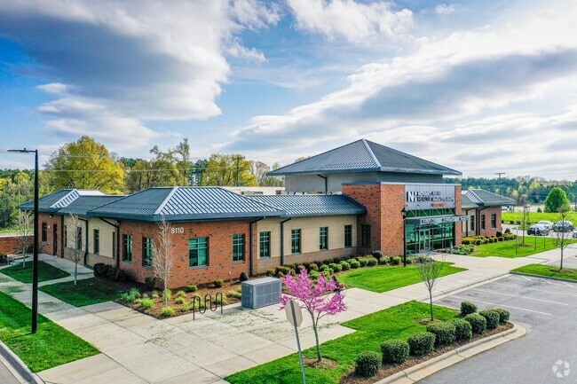
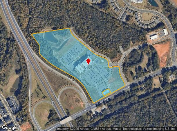
8201 Healthcare Loop
111-201-72
L1 M74-527
Medicalbuilding
Mecklenburg
X
North Carolina
3710550400K
1
0
34.03 AC
2025
East Charlotte
005621
Charlotte
261,708 SF
Charlotte-Concord-Gastonia, NC-SC
DEMOGRAPHICS near 8201 Healthcare Loop
1 Mile
3 Mile
5 Mile
2024 Total Population
4,827
38,890
101,080
2029 Population
5,222
41,673
107,811
Pop Growth 2024-2029
+ 8.18%
+ 7.16%
+ 6.66%
Average Age
37
38
38
2024 Total Households
1,695
13,361
35,902
HH Growth 2024-2029
+ 7.96%
+ 7.06%
+ 6.47%
Median Household Inc
$72,090
$70,931
$70,111
Avg Household Size
2.80
2.80
2.70
2024 Avg HH Vehicles
2.00
2.00
2.00
Median Home Value
$264,509
$275,404
$288,103
Median Year Built
2010
1999
1993
Nearby Places
Map Layers
Map Styles
 Street
 Aerial
- Restaurants
- Banks
- Shops
- Fitness
- Groceries
PUBLIC TRANSPORTATION
AIRPORT
Concord-Padgett Regional
DRIVE
WALK
Distance
Concord-Padgett Regional
21 min
15.3 mi
Charlotte/Douglas International
DRIVE
WALK
Distance
Charlotte/Douglas International
36 min
20.3 mi
Freight Ports
North Charleston Terminal
DRIVE
WALK
Distance
North Charleston Terminal
245 min
215.2 mi
Nearby Properties
Address
Land Use
TOTAL SIZE
Lot Size
Zoning
Address
Land Use
TOTAL SIZE
Lot Size
Zoning
539,702 SF
83.70 AC
I
Address
Land Use
TOTAL SIZE
Lot Size
Zoning
315,436 SF
23.89 AC
R3
Address
Land Use
TOTAL SIZE
Lot Size
Zoning
290,268 SF
19.96 AC
R17MFCD
Address
Land Use
TOTAL SIZE
Lot Size
Zoning
187,371 SF
7.31 AC
Address
Land Use
TOTAL SIZE
Lot Size
Zoning
333,774 SF
64.04 AC
I
Address
Land Use
TOTAL SIZE
Lot Size
Zoning
96,071 SF
7.44 AC
Address
Land Use
TOTAL SIZE
Lot Size
Zoning
239,983 SF
21.41 AC
I-G(CD)
Address
Land Use
TOTAL SIZE
Lot Size
Zoning
58,134 SF
5.08 AC
IGCUD
Address
Land Use
TOTAL SIZE
Lot Size
Zoning
104,386 SF
13 AC
R4
Address
Land Use
TOTAL SIZE
Lot Size
Zoning
146,650 SF
15.45 AC
CC
Address
Land Use
TOTAL SIZE
Lot Size
Zoning
124,191 SF
13.86 AC
CC
Address
Land Use
TOTAL SIZE
Lot Size
Zoning
104,214 SF
1.69 AC
MUDD-O
Address
Land Use
TOTAL SIZE
Lot Size
Zoning
120,944 SF
16.40 AC
R-15(CD)
Address
Land Use
TOTAL SIZE
Lot Size
Zoning
62,619 SF
11.93 AC
I-G(CD)
Address
Land Use
TOTAL SIZE
Lot Size
Zoning
108,786 SF
9.95 AC
I1
Address
Land Use
TOTAL SIZE
Lot Size
Zoning
49,878 SF
6.11 AC
Address
Land Use
TOTAL SIZE
Lot Size
Zoning
108,250 SF
10.07 AC
CC
Address
Land Use
TOTAL SIZE
Lot Size
Zoning
55,576 SF
10.80 AC
CC
Address
Land Use
TOTAL SIZE
Lot Size
Zoning
68,653 SF
17.30 AC
R3
Address
Land Use
TOTAL SIZE
Lot Size
Zoning
69,108 SF
14.95 AC
I-G(CD)
Address
Land Use
TOTAL SIZE
Lot Size
Zoning
3,614 SF
7.57 AC
NS
Address
Land Use
TOTAL SIZE
Lot Size
Zoning
50,042 SF
7.89 AC
INST
Address
Land Use
TOTAL SIZE
Lot Size
Zoning
46,438 SF
7.90 AC
B1SCD
Address
Land Use
TOTAL SIZE
Lot Size
Zoning
45,576 SF
5.75 AC
R12MFCD
Address
Land Use
TOTAL SIZE
Lot Size
Zoning
54,051 SF
25.06 AC
CR
Address
Land Use
TOTAL SIZE
Lot Size
Zoning
720 SF
35.60 AC
O-2(CD)
Address
Land Use
TOTAL SIZE
Lot Size
Zoning
37,376 SF
3.68 AC
Address
Land Use
TOTAL SIZE
Lot Size
Zoning
75,631 SF
4.30 AC
R4
Address
Land Use
TOTAL SIZE
Lot Size
Zoning
188.38 AC
R-3
The World's #1 Commercial Real Estate Marketplace
Connect with us
© 2026 CoStar Group
The information above has been obtained from sources believed reliable. While we do not doubt its accuracy we have not verified it and make no guarantee, warranty or representation about it. It is your responsibility to independently confirm its accuracy and completeness. Any projections, opinions, assumptions, or estimates used are for example only and do not represent the current or future performance of the property. The value of this transaction to you depends on tax and other factors which should be evaluated by your tax, financial, and legal advisors. You and your advisors should conduct a careful, independent investigation of the property to determine to your satisfaction the suitability of the property for your needs.