Property Record
8201 N Pine Island Rd B Ave, Tamarac, FL 33321


NEARBY LISTINGS FOR SALE OR LEASE
Property Detail
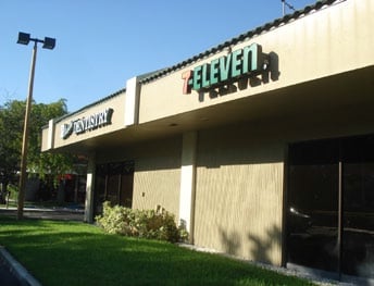
8201 N Pine Island Rd B Ave
49-41-05-17-0041
Tamarac Town Square 112-1 B
Officebuilding
TAMARAC TOWN SQUARE 112-1 B POR PAR A DESC AS COMM NW COR PAR A,E 158.62,SE 200.90,E 141.63,S 181.67,E 193,S 152.96, SW 130.76,S 200,E 12,S 67.86,SW 75.95,S 23.83,W 57.34TO POB,W 92.75,N 69.50,E 92.75,S 69.50 TO POB
AH
Broward
12011C0335H
Florida
2024
0.07 AC
2025
NW Broward/Coral Springs
020418
South Florida
2,459 SF
Fort Lauderdale-Pompano Beach-Deerfield Beach, FL
DEMOGRAPHICS near 8201 N Pine Island Rd B Ave
1 Mile
3 Mile
5 Mile
2024 Total Population
16,520
141,952
361,645
2029 Population
16,474
140,515
358,871
Pop Growth 2024-2029
(0.28%)
(1.01%)
(0.77%)
Average Age
42
42
41
2024 Total Households
6,544
53,665
134,538
HH Growth 2024-2029
(0.47%)
(1.40%)
(1.10%)
Median Household Inc
$76,193
$63,512
$60,549
Avg Household Size
2.40
2.50
2.60
2024 Avg HH Vehicles
2.00
2.00
2.00
Median Home Value
$326,579
$281,872
$279,244
Median Year Built
1985
1982
1980
Nearby Places
Map Layers
Map Styles
 Street
 Aerial
- Restaurants
- Banks
- Shops
- Fitness
- Groceries
PUBLIC TRANSPORTATION
COMMUTER RAIL
Cypress Creek (Tri-County Commuter - South Florida Regional Transportation Authority (Tri-Rail))
DRIVE
WALK
Distance
Cypress Creek (Tri-County Commuter - South Florida Regional Transportation Authority (Tri-Rail))
17 min
9.3 mi
AIRPORT
Fort Lauderdale/Hollywood International
DRIVE
WALK
Distance
Fort Lauderdale/Hollywood International
32 min
17.0 mi
Miami International
DRIVE
WALK
Distance
Miami International
50 min
37.3 mi
Freight Ports
Port Everglades
DRIVE
WALK
Distance
Port Everglades
31 min
19.0 mi
SALE & LEASE HISTORY
LISTING DATE
SALE/LEASE

Nov 17, 2020
For Lease
May 13, 2021
For Lease
Nearby Properties
Address
Land Use
TOTAL SIZE
Lot Size
Zoning
Address
Land Use
TOTAL SIZE
Lot Size
Zoning
399,296 SF
20.23 AC
RM-40
Address
Land Use
TOTAL SIZE
Lot Size
Zoning
842,307 SF
55.40 AC
BP
Address
Land Use
TOTAL SIZE
Lot Size
Zoning
362,362 SF
17.20 AC
RM-16
Address
Land Use
TOTAL SIZE
Lot Size
Zoning
344,358 SF
23.27 AC
RM-20
Address
Land Use
TOTAL SIZE
Lot Size
Zoning
347,840 SF
16.76 AC
RM-20
Address
Land Use
TOTAL SIZE
Lot Size
Zoning
325,412 SF
6.95 AC
PD
Address
Land Use
TOTAL SIZE
Lot Size
Zoning
294,706 SF
17.10 AC
RM-20
Address
Land Use
TOTAL SIZE
Lot Size
Zoning
328,631 SF
19.96 AC
R-3
Address
Land Use
TOTAL SIZE
Lot Size
Zoning
239,102 SF
7.01 AC
MU-N
Address
Land Use
TOTAL SIZE
Lot Size
Zoning
177,793 SF
22.35 AC
BP
Address
Land Use
TOTAL SIZE
Lot Size
Zoning
566,155 SF
38.24 AC
B-3
Address
Land Use
TOTAL SIZE
Lot Size
Zoning
391,305 SF
30.78 AC
CF-E
Address
Land Use
TOTAL SIZE
Lot Size
Zoning
261,652 SF
13.64 AC
RM-16
Address
Land Use
TOTAL SIZE
Lot Size
Zoning
188,516 SF
4.59 AC
PD
Address
Land Use
TOTAL SIZE
Lot Size
Zoning
157,914 SF
15.11 AC
B-3
Address
Land Use
TOTAL SIZE
Lot Size
Zoning
401,920 SF
16.93 AC
RM-15
Address
Land Use
TOTAL SIZE
Lot Size
Zoning
242,692 SF
17.25 AC
RM-20
Address
Land Use
TOTAL SIZE
Lot Size
Zoning
156,626 SF
14.91 AC
R-3
Address
Land Use
TOTAL SIZE
Lot Size
Zoning
256,572 SF
17.68 AC
R-3
Address
Land Use
TOTAL SIZE
Lot Size
Zoning
123,317 SF
10.48 AC
B-2
Address
Land Use
TOTAL SIZE
Lot Size
Zoning
194,766 SF
13.35 AC
RC
Address
Land Use
TOTAL SIZE
Lot Size
Zoning
269,994 SF
10.66 AC
RM-16
Address
Land Use
TOTAL SIZE
Lot Size
Zoning
229,695 SF
20.17 AC
MU-G
Address
Land Use
TOTAL SIZE
Lot Size
Zoning
293,533 SF
10.04 AC
RM-20
Address
Land Use
TOTAL SIZE
Lot Size
Zoning
158,317 SF
17.64 AC
R-3
Address
Land Use
TOTAL SIZE
Lot Size
Zoning
201,120 SF
12.55 AC
MU-C
Address
Land Use
TOTAL SIZE
Lot Size
Zoning
403,338 SF
8.20 AC
B-3
Address
Land Use
TOTAL SIZE
Lot Size
Zoning
179,157 SF
16.70 AC
R-3
Address
Land Use
TOTAL SIZE
Lot Size
Zoning
144,539 SF
7.44 AC
RM-20
Address
Land Use
TOTAL SIZE
Lot Size
Zoning
285,596 SF
17.62 AC
BP
The World's #1 Commercial Real Estate Marketplace
Connect with us
© 2025 CoStar Group
The information above has been obtained from sources believed reliable. While we do not doubt its accuracy we have not verified it and make no guarantee, warranty or representation about it. It is your responsibility to independently confirm its accuracy and completeness. Any projections, opinions, assumptions, or estimates used are for example only and do not represent the current or future performance of the property. The value of this transaction to you depends on tax and other factors which should be evaluated by your tax, financial, and legal advisors. You and your advisors should conduct a careful, independent investigation of the property to determine to your satisfaction the suitability of the property for your needs.