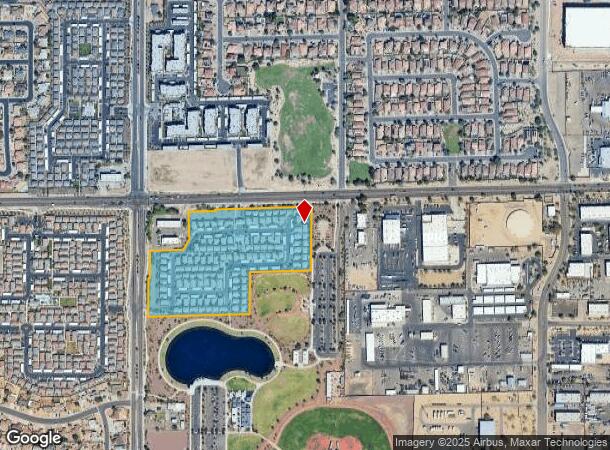
Property Record
8201 W Olive Ave, Peoria, AZ 85345

NEARBY LISTINGS FOR SALE OR LEASE
Property Detail
8201 W Olive Ave
Phoenix-Mesa-Scottsdale, AZ
83Rd And Olive Promenade Lot 2 Replat
142-21-010
83RD AND OLIVE PROMENADE LOT 2 REPLAT MCR 1299-37
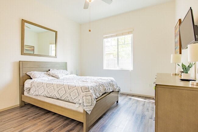
Apartment
Maricopa
X
Arizona
04013C1705M
2
2025
12.65 AC
2025
South Peoria
093200
Phoenix
147,045 SF
DEMOGRAPHICS near 8201 W Olive Ave
1 Mile
3 Mile
5 Mile
2024 Total Population
10,608
135,088
365,369
2029 Population
11,691
146,402
395,384
Pop Growth 2024-2029
+ 10.21%
+ 8.38%
+ 8.21%
Average Age
36
38
39
2024 Total Households
3,430
48,050
131,118
HH Growth 2024-2029
+ 10.41%
+ 8.48%
+ 8.39%
Median Household Inc
$76,801
$60,826
$59,178
Avg Household Size
2.90
2.70
2.70
2024 Avg HH Vehicles
2.00
2.00
2.00
Median Home Value
$371,296
$283,409
$274,444
Median Year Built
1997
1987
1983
Nearby Places
Map Layers
Map Styles
 Street
 Aerial
- Restaurants
- Banks
- Shops
- Fitness
- Groceries
PUBLIC TRANSPORTATION
AIRPORT
Phoenix Sky Harbor International
DRIVE
WALK
Distance
Phoenix Sky Harbor International
33 min
19.0 mi
Freight Ports
Port of San Diego
DRIVE
WALK
Distance
Port of San Diego
392 min
352.3 mi
SALE & LEASE HISTORY
LISTING DATE
SALE/LEASE

Jul 18, 2019
For Sale
Nearby Properties
Address
Land Use
TOTAL SIZE
Lot Size
Zoning
Address
Land Use
TOTAL SIZE
Lot Size
Zoning
127,011 SF
30.62 AC
PAD
Address
Land Use
TOTAL SIZE
Lot Size
Zoning
15.17 AC
Address
Land Use
TOTAL SIZE
Lot Size
Zoning
0.68 AC
Address
Land Use
TOTAL SIZE
Lot Size
Zoning
630,367 SF
13.50 AC
PAD
Address
Land Use
TOTAL SIZE
Lot Size
Zoning
Address
Land Use
TOTAL SIZE
Lot Size
Zoning
13,861 SF
3.40 AC
PAD
Address
Land Use
TOTAL SIZE
Lot Size
Zoning
242,300 SF
41.79 AC
C-C
Address
Land Use
TOTAL SIZE
Lot Size
Zoning
443,840 SF
37.94 AC
PAD
Address
Land Use
TOTAL SIZE
Lot Size
Zoning
611,971 SF
36.16 AC
A1
Address
Land Use
TOTAL SIZE
Lot Size
Zoning
285,815 SF
37.17 AC
R-6
Address
Land Use
TOTAL SIZE
Lot Size
Zoning
926 SF
37.32 AC
I-1
Address
Land Use
TOTAL SIZE
Lot Size
Zoning
359,639 SF
16.29 AC
PAD
Address
Land Use
TOTAL SIZE
Lot Size
Zoning
603,148 SF
13.63 AC
PAD
Address
Land Use
TOTAL SIZE
Lot Size
Zoning
303,051 SF
9.11 AC
AG
Address
Land Use
TOTAL SIZE
Lot Size
Zoning
135,052 SF
5.52 AC
PAD
Address
Land Use
TOTAL SIZE
Lot Size
Zoning
307,822 SF
26.49 AC
PAD
Address
Land Use
TOTAL SIZE
Lot Size
Zoning
310,295 SF
9.32 AC
Address
Land Use
TOTAL SIZE
Lot Size
Zoning
353,859 SF
11.71 AC
PAD
Address
Land Use
TOTAL SIZE
Lot Size
Zoning
366,400 SF
19.99 AC
PAD
Address
Land Use
TOTAL SIZE
Lot Size
Zoning
342,527 SF
16.52 AC
PAD
Address
Land Use
TOTAL SIZE
Lot Size
Zoning
330,321 SF
3.85 AC
PAD
Address
Land Use
TOTAL SIZE
Lot Size
Zoning
637,538 SF
9.74 AC
Address
Land Use
TOTAL SIZE
Lot Size
Zoning
334,769 SF
12.01 AC
Address
Land Use
TOTAL SIZE
Lot Size
Zoning
4,742 SF
1.18 AC
PAD
Address
Land Use
TOTAL SIZE
Lot Size
Zoning
325,529 SF
10.85 AC
PAD
Address
Land Use
TOTAL SIZE
Lot Size
Zoning
262,609 SF
18.96 AC
I-1
Address
Land Use
TOTAL SIZE
Lot Size
Zoning
131,031 SF
26.44 AC
R-43
Address
Land Use
TOTAL SIZE
Lot Size
Zoning
88,059 SF
78.03 AC
AG
Address
Land Use
TOTAL SIZE
Lot Size
Zoning
321,976 SF
13 AC
R-43
Address
Land Use
TOTAL SIZE
Lot Size
Zoning
217,214 SF
27.12 AC
R-6
The World's #1 Commercial Real Estate Marketplace
Connect with us
© 2025 CoStar Group
The information above has been obtained from sources believed reliable. While we do not doubt its accuracy we have not verified it and make no guarantee, warranty or representation about it. It is your responsibility to independently confirm its accuracy and completeness. Any projections, opinions, assumptions, or estimates used are for example only and do not represent the current or future performance of the property. The value of this transaction to you depends on tax and other factors which should be evaluated by your tax, financial, and legal advisors. You and your advisors should conduct a careful, independent investigation of the property to determine to your satisfaction the suitability of the property for your needs.