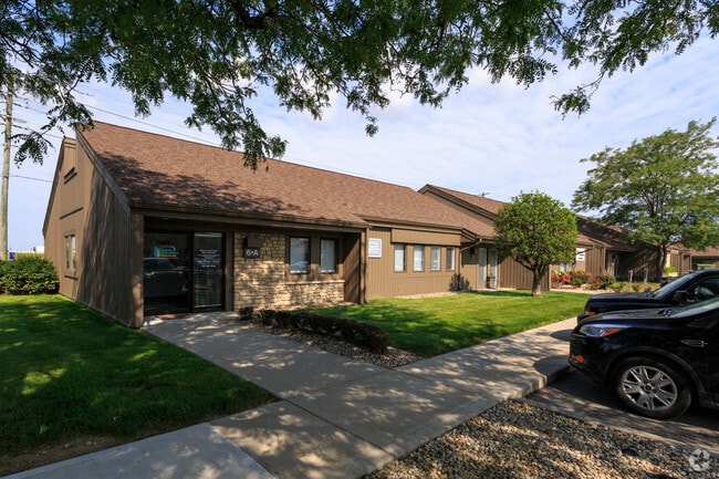
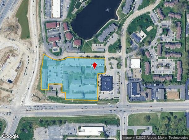
Property Record
8202 Clearvista Pkwy, Indianapolis, IN 46256

NEARBY LISTINGS FOR SALE OR LEASE
Property Detail
8202 Clearvista Pkwy
49-02-23-111-006.000-400
Plat Of Regency Centre
Storebuilding
PT SW1/4 NE1/4 & PT SE1/4 NW1/4 S23 T17 R4 BEG 72 N 40 NE & 34 E OF SW COR SW1/4 NE1/4 P.O.B. SE307.4 N259.3 E66.28 NE7.08 N144.1 W372.84 IRR W250.63 SW164.13 S183.36 E73.1 N58 E128 S81 E35 S68.44 TO BEG 4.64AC
X
Marion
18097C0068F
Indiana
2023
4.64 AC
2024
Castleton
330106
Indianapolis
21,600 SF
Indianapolis-Carmel-Anderson, IN
DEMOGRAPHICS near 8202 Clearvista Pkwy
1 Mile
3 Mile
5 Mile
2024 Total Population
7,911
49,644
165,722
2029 Population
7,838
49,793
170,338
Pop Growth 2024-2029
(0.92%)
+ 0.30%
+ 2.79%
Average Age
38
40
40
2024 Total Households
4,125
23,010
71,176
HH Growth 2024-2029
(0.85%)
+ 0.27%
+ 2.53%
Median Household Inc
$51,659
$72,817
$78,617
Avg Household Size
1.80
2.10
2.30
2024 Avg HH Vehicles
1.00
2.00
2.00
Median Home Value
$187,779
$256,648
$270,977
Median Year Built
1984
1984
1985
Nearby Places
- Restaurants
- Banks
- Shops
- Fitness
- Groceries
PUBLIC TRANSPORTATION
AIRPORT
Indianapolis International
DRIVE
WALK
Distance
Indianapolis International
46 min
27.0 mi
Nearby Properties
Address
Land Use
TOTAL SIZE
Lot Size
Zoning
Address
Land Use
TOTAL SIZE
Lot Size
Zoning
366,825 SF
26.60 AC
ZO01
Address
Land Use
TOTAL SIZE
Lot Size
Zoning
21,742 SF
39.35 AC
ZO01
Address
Land Use
TOTAL SIZE
Lot Size
Zoning
8,551 SF
45.92 AC
ZO01
Address
Land Use
TOTAL SIZE
Lot Size
Zoning
16,704 SF
109.83 AC
ZO01
Address
Land Use
TOTAL SIZE
Lot Size
Zoning
4,246 SF
89.83 AC
ZO01
Address
Land Use
TOTAL SIZE
Lot Size
Zoning
22,081 SF
27.39 AC
ZO01
Address
Land Use
TOTAL SIZE
Lot Size
Zoning
10,911 SF
11.56 AC
ZO01
Address
Land Use
TOTAL SIZE
Lot Size
Zoning
683,795 SF
25.53 AC
Address
Land Use
TOTAL SIZE
Lot Size
Zoning
328,241 SF
91.83 AC
Address
Land Use
TOTAL SIZE
Lot Size
Zoning
3,053 SF
10.33 AC
ZO01
Address
Land Use
TOTAL SIZE
Lot Size
Zoning
372,138 SF
20.71 AC
Address
Land Use
TOTAL SIZE
Lot Size
Zoning
5,314 SF
13.92 AC
ZO01
Address
Land Use
TOTAL SIZE
Lot Size
Zoning
125.31 AC
Address
Land Use
TOTAL SIZE
Lot Size
Zoning
6,252 SF
52.04 AC
ZO01
Address
Land Use
TOTAL SIZE
Lot Size
Zoning
1,904 SF
67.93 AC
ZO01
Address
Land Use
TOTAL SIZE
Lot Size
Zoning
6,229 SF
36.20 AC
ZO01
Address
Land Use
TOTAL SIZE
Lot Size
Zoning
6,366 SF
19.40 AC
ZO01
Address
Land Use
TOTAL SIZE
Lot Size
Zoning
217,633 SF
78.75 AC
Address
Land Use
TOTAL SIZE
Lot Size
Zoning
24,192 SF
5.93 AC
Address
Land Use
TOTAL SIZE
Lot Size
Zoning
308,854 SF
13.64 AC
Address
Land Use
TOTAL SIZE
Lot Size
Zoning
91,717 SF
37.30 AC
Address
Land Use
TOTAL SIZE
Lot Size
Zoning
118,729 SF
13.39 AC
ZO01
Address
Land Use
TOTAL SIZE
Lot Size
Zoning
151,823 SF
57.55 AC
ZO01
Address
Land Use
TOTAL SIZE
Lot Size
Zoning
23,452 SF
14.94 AC
ZO01
Address
Land Use
TOTAL SIZE
Lot Size
Zoning
293,429 SF
25.88 AC
ZO01
Address
Land Use
TOTAL SIZE
Lot Size
Zoning
190,460 SF
13.32 AC
Address
Land Use
TOTAL SIZE
Lot Size
Zoning
13,087 SF
57.88 AC
Address
Land Use
TOTAL SIZE
Lot Size
Zoning
118,439 SF
10.88 AC
ZO01
Address
Land Use
TOTAL SIZE
Lot Size
Zoning
178,697 SF
13.46 AC
Address
Land Use
TOTAL SIZE
Lot Size
Zoning
260,937 SF
24.61 AC
ZO01
The World's #1 Commercial Real Estate Marketplace
Connect with us
© 2025 CoStar Group
The information above has been obtained from sources believed reliable. While we do not doubt its accuracy we have not verified it and make no guarantee, warranty or representation about it. It is your responsibility to independently confirm its accuracy and completeness. Any projections, opinions, assumptions, or estimates used are for example only and do not represent the current or future performance of the property. The value of this transaction to you depends on tax and other factors which should be evaluated by your tax, financial, and legal advisors. You and your advisors should conduct a careful, independent investigation of the property to determine to your satisfaction the suitability of the property for your needs.