Property Record
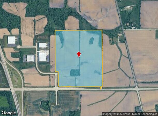
8202 W Lane Rd, Caledonia, IL 61011
Current Lease Availabilities
NEARBY LISTINGS FOR SALE OR LEASE
Property Detail
8202 W Lane Rd
08-13-300-011
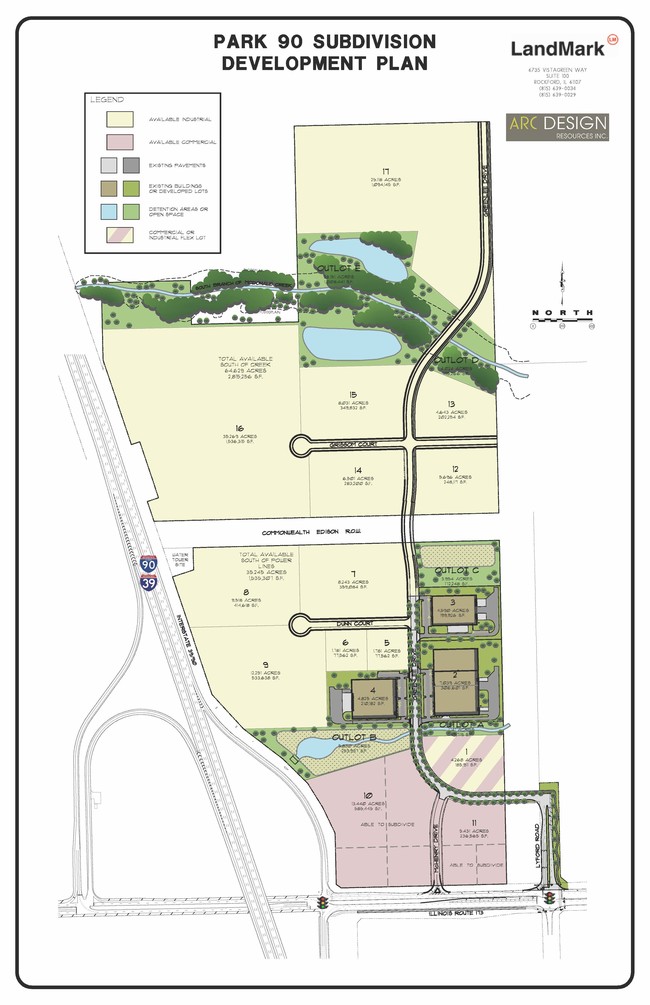
SW1/4 (EXC ROW BY 2013-1034004) (EXC W235 FT) (EXC E 331.82 FT) (EXC .10A NON-FARM 08-13-300-008) (EXC ROW BY 06-02288 & 06-02289) SEC 13-45-2 120.18A(
Farms
Winnebago
AE
Illinois
17201C0277D
120.18 AC
2024
I-39 Cor/Winnebago Cy
2024
Chicago
003806
Rockford, IL
2,356 SF
DEMOGRAPHICS near 8202 W Lane Rd
1 Mile
3 Mile
5 Mile
2024 Total Population
32
9,721
53,245
2029 Population
31
9,581
52,555
Pop Growth 2024-2029
(3.13%)
(1.44%)
(1.30%)
Average Age
45
41
42
2024 Total Households
12
3,711
21,071
HH Growth 2024-2029
0.00%
(1.43%)
(1.34%)
Median Household Inc
$137,500
$98,091
$83,065
Avg Household Size
2.60
2.60
2.50
2024 Avg HH Vehicles
2.00
2.00
2.00
Median Home Value
$250,000
$203,917
$174,181
Median Year Built
1987
2000
1991
Nearby Places
Map Layers
Map Styles
 Street
 Aerial
- Restaurants
- Banks
- Shops
- Fitness
- Groceries
PUBLIC TRANSPORTATION
AIRPORT
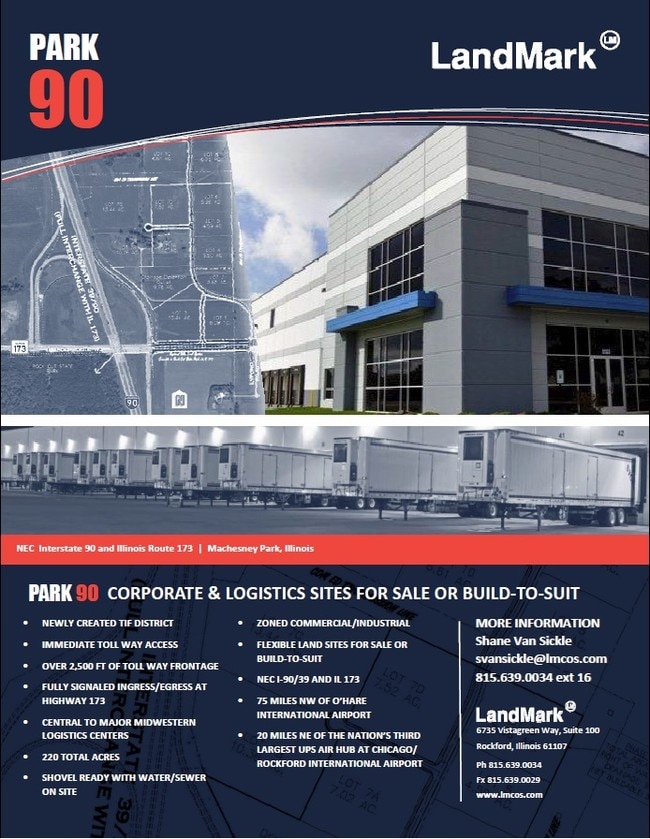
Chicago/Rockford International
DRIVE
WALK
Distance
Chicago/Rockford International
33 min
22.0 mi
Freight Ports
Port Milwaukee
DRIVE
WALK
Distance
Port Milwaukee
98 min
82.6 mi
Nearby Properties
Address
Land Use
TOTAL SIZE
Lot Size
Zoning
Address
Land Use
TOTAL SIZE
Lot Size
Zoning
105,664 SF
13.34 AC
Address
Land Use
TOTAL SIZE
Lot Size
Zoning
Address
Land Use
TOTAL SIZE
Lot Size
Zoning
192,604 SF
17.05 AC
Address
Land Use
TOTAL SIZE
Lot Size
Zoning
90,000 SF
7.04 AC
SI - SING
Address
Land Use
TOTAL SIZE
Lot Size
Zoning
Address
Land Use
TOTAL SIZE
Lot Size
Zoning
80,000 SF
4.82 AC
Address
Land Use
TOTAL SIZE
Lot Size
Zoning
55,200 SF
10.17 AC
Address
Land Use
TOTAL SIZE
Lot Size
Zoning
60,000 SF
4.59 AC
Address
Land Use
TOTAL SIZE
Lot Size
Zoning
29.92 AC
Address
Land Use
TOTAL SIZE
Lot Size
Zoning
38,200 SF
5.68 AC
Address
Land Use
TOTAL SIZE
Lot Size
Zoning
3,744 SF
12.71 AC
Address
Land Use
TOTAL SIZE
Lot Size
Zoning
Address
Land Use
TOTAL SIZE
Lot Size
Zoning
2,897 SF
0.73 AC
Address
Land Use
TOTAL SIZE
Lot Size
Zoning
20.07 AC
Address
Land Use
TOTAL SIZE
Lot Size
Zoning
Address
Land Use
TOTAL SIZE
Lot Size
Zoning
3,341 SF
0.56 AC
Address
Land Use
TOTAL SIZE
Lot Size
Zoning
1.27 AC
LI - LIGHT
Address
Land Use
TOTAL SIZE
Lot Size
Zoning
Address
Land Use
TOTAL SIZE
Lot Size
Zoning
10,152 SF
1.24 AC
Address
Land Use
TOTAL SIZE
Lot Size
Zoning
6,010 SF
55.70 AC
AG
Address
Land Use
TOTAL SIZE
Lot Size
Zoning
6,996 SF
1.09 AC
Address
Land Use
TOTAL SIZE
Lot Size
Zoning
2,509 SF
5 AC
AG
Address
Land Use
TOTAL SIZE
Lot Size
Zoning
7,200 SF
2.67 AC
IH - HEAVY
Address
Land Use
TOTAL SIZE
Lot Size
Zoning
17.27 AC
Address
Land Use
TOTAL SIZE
Lot Size
Zoning
2,144 SF
29.41 AC
AG
Address
Land Use
TOTAL SIZE
Lot Size
Zoning
5,910 SF
0.54 AC
Address
Land Use
TOTAL SIZE
Lot Size
Zoning
3,849 SF
10.03 AC
AG
Address
Land Use
TOTAL SIZE
Lot Size
Zoning
5,910 SF
0.42 AC
Address
Land Use
TOTAL SIZE
Lot Size
Zoning
5,910 SF
0.42 AC
Address
Land Use
TOTAL SIZE
Lot Size
Zoning
5,910 SF
0.42 AC
The World's #1 Commercial Real Estate Marketplace
Connect with us
© 2026 CoStar Group
The information above has been obtained from sources believed reliable. While we do not doubt its accuracy we have not verified it and make no guarantee, warranty or representation about it. It is your responsibility to independently confirm its accuracy and completeness. Any projections, opinions, assumptions, or estimates used are for example only and do not represent the current or future performance of the property. The value of this transaction to you depends on tax and other factors which should be evaluated by your tax, financial, and legal advisors. You and your advisors should conduct a careful, independent investigation of the property to determine to your satisfaction the suitability of the property for your needs.