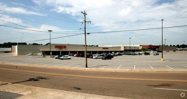
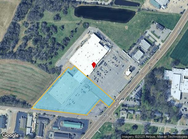
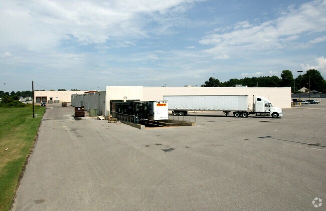
Property Record
8209 Us Highway 51 N, Millington, TN 38053
NEARBY LISTINGS FOR SALE OR LEASE
Property Detail
8209 Us Highway 51 N
Memphis, TN-MS-AR
Haddad Resub
M0-115-A-00029
WS US HWY 51 N TO NS CUBA MILLINGTON RD SEE MAP-25 E
Regionalshoppingcenterormallwithanchorstore
Shelby
X
Tennessee
47157C0160G
1
2021
5.22 AC
2025
North
020302
Memphis
66,479 SF
DEMOGRAPHICS near 8209 Us Highway 51 N
1 Mile
3 Mile
5 Mile
2024 Total Population
3,438
9,717
22,370
2029 Population
3,387
9,543
22,157
Pop Growth 2024-2029
(1.48%)
(1.79%)
(0.95%)
Average Age
41
40
40
2024 Total Households
1,538
3,971
8,623
HH Growth 2024-2029
(1.56%)
(1.86%)
(1.08%)
Median Household Inc
$41,398
$50,710
$57,457
Avg Household Size
2.20
2.40
2.50
2024 Avg HH Vehicles
1.00
2.00
2.00
Median Home Value
$184,895
$185,040
$190,064
Median Year Built
1964
1970
1978
Nearby Places
Map Layers
Map Styles
 Street
 Aerial
- Restaurants
- Banks
- Shops
- Fitness
- Groceries
PUBLIC TRANSPORTATION
AIRPORT
Memphis International
DRIVE
WALK
Distance
Memphis International
37 min
26.3 mi
Freight Ports
Port of Shreveport
DRIVE
WALK
Distance
Port of Shreveport
419 min
384.9 mi
SALE & LEASE HISTORY
LISTING DATE
SALE/LEASE

Sep 25, 2016
For Lease
Oct 20, 2017
For Sale
Apr 06, 2018
For Lease
Nearby Properties
Address
Land Use
TOTAL SIZE
Lot Size
Zoning
Address
Land Use
TOTAL SIZE
Lot Size
Zoning
625,426 SF
38.85 AC
M-2
Address
Land Use
TOTAL SIZE
Lot Size
Zoning
1,534.16 AC
MT
Address
Land Use
TOTAL SIZE
Lot Size
Zoning
150,026 SF
25.55 AC
B-2
Address
Land Use
TOTAL SIZE
Lot Size
Zoning
619.59 AC
M-2
Address
Land Use
TOTAL SIZE
Lot Size
Zoning
202,614 SF
19.78 AC
P-C
Address
Land Use
TOTAL SIZE
Lot Size
Zoning
22,232 SF
10.55 AC
R-4
Address
Land Use
TOTAL SIZE
Lot Size
Zoning
108,870 SF
12.63 AC
R-0
Address
Land Use
TOTAL SIZE
Lot Size
Zoning
105,516 SF
11.74 AC
R-4
Address
Land Use
TOTAL SIZE
Lot Size
Zoning
62,477 SF
1.60 AC
B-2
Address
Land Use
TOTAL SIZE
Lot Size
Zoning
107,077 SF
10.98 AC
P-C
Address
Land Use
TOTAL SIZE
Lot Size
Zoning
17,690 SF
30.89 AC
CA
Address
Land Use
TOTAL SIZE
Lot Size
Zoning
26,350 SF
4.08 AC
P-C
Address
Land Use
TOTAL SIZE
Lot Size
Zoning
34,186 SF
2.54 AC
B-2
Address
Land Use
TOTAL SIZE
Lot Size
Zoning
148,903 SF
13.81 AC
P-C
Address
Land Use
TOTAL SIZE
Lot Size
Zoning
29,181 SF
2.68 AC
B-2
Address
Land Use
TOTAL SIZE
Lot Size
Zoning
76,055 SF
30.92 AC
M-1
Address
Land Use
TOTAL SIZE
Lot Size
Zoning
27.73 AC
M-2
Address
Land Use
TOTAL SIZE
Lot Size
Zoning
184.13 AC
M-2
Address
Land Use
TOTAL SIZE
Lot Size
Zoning
18,228 SF
4.41 AC
M-2
Address
Land Use
TOTAL SIZE
Lot Size
Zoning
73,893 SF
3.88 AC
B-2
Address
Land Use
TOTAL SIZE
Lot Size
Zoning
47,152 SF
7.82 AC
R-4
Address
Land Use
TOTAL SIZE
Lot Size
Zoning
44,100 SF
6.52 AC
B-2
Address
Land Use
TOTAL SIZE
Lot Size
Zoning
347.69 AC
M-2
Address
Land Use
TOTAL SIZE
Lot Size
Zoning
1,970 SF
143.36 AC
R-4
Address
Land Use
TOTAL SIZE
Lot Size
Zoning
62,621 SF
4.15 AC
P-C
Address
Land Use
TOTAL SIZE
Lot Size
Zoning
6,958 SF
224.25 AC
CA
Address
Land Use
TOTAL SIZE
Lot Size
Zoning
107.61 AC
M-2
Address
Land Use
TOTAL SIZE
Lot Size
Zoning
32,257 SF
1.75 AC
B-2
Address
Land Use
TOTAL SIZE
Lot Size
Zoning
24 AC
R-4
Address
Land Use
TOTAL SIZE
Lot Size
Zoning
11,200 SF
1.16 AC
P-C
The World's #1 Commercial Real Estate Marketplace
Connect with us
© 2026 CoStar Group
The information above has been obtained from sources believed reliable. While we do not doubt its accuracy we have not verified it and make no guarantee, warranty or representation about it. It is your responsibility to independently confirm its accuracy and completeness. Any projections, opinions, assumptions, or estimates used are for example only and do not represent the current or future performance of the property. The value of this transaction to you depends on tax and other factors which should be evaluated by your tax, financial, and legal advisors. You and your advisors should conduct a careful, independent investigation of the property to determine to your satisfaction the suitability of the property for your needs.