Property Record
821 S Polk St, Desoto, TX 75115

NEARBY LISTINGS FOR SALE OR LEASE
-
-
View all Desoto listings for sale on LoopNet.com
Property Detail
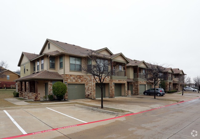
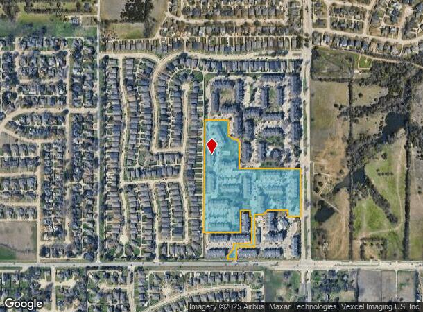
821 S Polk St
Dallas-Fort Worth-Arlington, TX
Huntington Ridge
200547500A0020000
HUNTINGTON RIDGE BLK A LT 2 ACS 13.855 INT202100356246 DD11292021 CO-DC 0547500A00200 5CS0547500A
Apartment
Dallas
X
Texas
48139C0055G
2
2024
13.86 AC
2025
South Dallas County
016628
Dallas/Ft Worth
227,423 SF
DEMOGRAPHICS near 821 S Polk St
1 Mile
3 Mile
5 Mile
2024 Total Population
11,946
70,551
150,776
2029 Population
11,827
72,642
157,385
Pop Growth 2024-2029
(1.00%)
+ 2.96%
+ 4.38%
Average Age
36
37
37
2024 Total Households
3,999
24,059
51,238
HH Growth 2024-2029
(1.20%)
+ 2.65%
+ 4.21%
Median Household Inc
$80,200
$77,790
$74,621
Avg Household Size
2.90
2.90
2.90
2024 Avg HH Vehicles
2.00
2.00
2.00
Median Home Value
$207,013
$233,037
$235,779
Median Year Built
1996
1994
1994
Nearby Places
Map Layers
Map Styles
 Street
 Aerial
- Restaurants
- Banks
- Shops
- Fitness
- Groceries
PUBLIC TRANSPORTATION
AIRPORT
Dallas Love Field
DRIVE
WALK
Distance
Dallas Love Field
34 min
21.7 mi
Dallas-Fort Worth International
DRIVE
WALK
Distance
Dallas-Fort Worth International
45 min
33.6 mi
Freight Ports
Port of Shreveport
DRIVE
WALK
Distance
Port of Shreveport
220 min
202.9 mi
Nearby Properties
Address
Land Use
TOTAL SIZE
Lot Size
Zoning
Address
Land Use
TOTAL SIZE
Lot Size
Zoning
123,880 SF
16.80 AC
Z236
Address
Land Use
TOTAL SIZE
Lot Size
Zoning
507,318 SF
28.40 AC
Z111
Address
Land Use
TOTAL SIZE
Lot Size
Zoning
281,669 SF
16.02 AC
Z312
Address
Land Use
TOTAL SIZE
Lot Size
Zoning
330,541 SF
14.85 AC
Address
Land Use
TOTAL SIZE
Lot Size
Zoning
253,794 SF
10.23 AC
Z201
Address
Land Use
TOTAL SIZE
Lot Size
Zoning
140,590 SF
4.90 AC
Z236
Address
Land Use
TOTAL SIZE
Lot Size
Zoning
190,592 SF
101.54 AC
Z370
Address
Land Use
TOTAL SIZE
Lot Size
Zoning
209,742 SF
9.45 AC
Z175
Address
Land Use
TOTAL SIZE
Lot Size
Zoning
206,992 SF
14.25 AC
Z188
Address
Land Use
TOTAL SIZE
Lot Size
Zoning
210,008 SF
8.53 AC
Z175
Address
Land Use
TOTAL SIZE
Lot Size
Zoning
55,213 SF
11.83 AC
Z197
Address
Land Use
TOTAL SIZE
Lot Size
Zoning
298,000 SF
21.24 AC
Z175
Address
Land Use
TOTAL SIZE
Lot Size
Zoning
161,008 SF
10.62 AC
Z188
Address
Land Use
TOTAL SIZE
Lot Size
Zoning
383 SF
56.48 AC
Z07
Address
Land Use
TOTAL SIZE
Lot Size
Zoning
169,164 SF
10.79 AC
Z187
Address
Land Use
TOTAL SIZE
Lot Size
Zoning
191,240 SF
13.73 AC
Z109
Address
Land Use
TOTAL SIZE
Lot Size
Zoning
215,220 SF
11.95 AC
Address
Land Use
TOTAL SIZE
Lot Size
Zoning
109,500 SF
12.13 AC
Z370
Address
Land Use
TOTAL SIZE
Lot Size
Zoning
207,120 SF
10 AC
Z175
Address
Land Use
TOTAL SIZE
Lot Size
Zoning
135,448 SF
9.79 AC
Z160
Address
Land Use
TOTAL SIZE
Lot Size
Zoning
116,640 SF
6 AC
Z175
Address
Land Use
TOTAL SIZE
Lot Size
Zoning
125,586 SF
11.71 AC
Z187
Address
Land Use
TOTAL SIZE
Lot Size
Zoning
276,880 SF
14.17 AC
Address
Land Use
TOTAL SIZE
Lot Size
Zoning
327,382 SF
15.68 AC
Address
Land Use
TOTAL SIZE
Lot Size
Zoning
152,733 SF
9.87 AC
Z187
Address
Land Use
TOTAL SIZE
Lot Size
Zoning
158,816 SF
8.41 AC
Address
Land Use
TOTAL SIZE
Lot Size
Zoning
232,072 SF
21.24 AC
Z39
Address
Land Use
TOTAL SIZE
Lot Size
Zoning
117,888 SF
21.28 AC
Z97
Address
Land Use
TOTAL SIZE
Lot Size
Zoning
83,920 SF
6.22 AC
Z188
The World's #1 Commercial Real Estate Marketplace
Connect with us
© 2026 CoStar Group
The information above has been obtained from sources believed reliable. While we do not doubt its accuracy we have not verified it and make no guarantee, warranty or representation about it. It is your responsibility to independently confirm its accuracy and completeness. Any projections, opinions, assumptions, or estimates used are for example only and do not represent the current or future performance of the property. The value of this transaction to you depends on tax and other factors which should be evaluated by your tax, financial, and legal advisors. You and your advisors should conduct a careful, independent investigation of the property to determine to your satisfaction the suitability of the property for your needs.