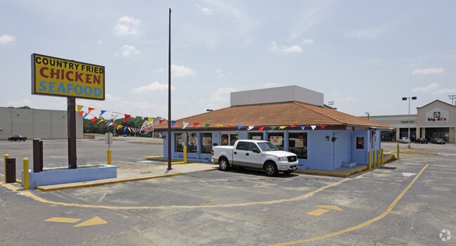
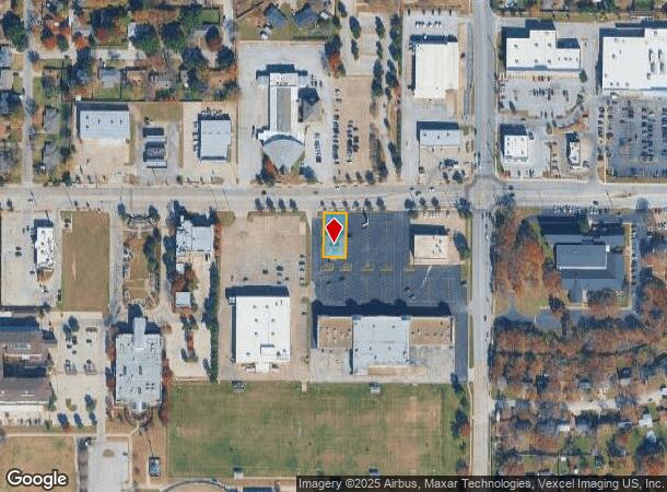
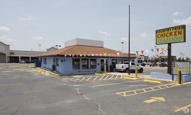
Property Record
821 W Pipeline Rd, Hurst, TX 76053
NEARBY LISTINGS FOR SALE OR LEASE
-
-
-
-
-
-
-
-
-
No Photo
-
-
-
-
-
-
-
View all Hurst listings for sale on LoopNet.com
Property Detail
821 W Pipeline Rd
Dallas-Fort Worth-Arlington, TX
Willows Addition, The Lot
03122468
WILLOWS ADDITION, THE LOT A2R1
Commercialnec
Tarrant
X
Texas
48439C0205L
a2r1
2024
0.21 AC
2025
Richland Hills
113410
Dallas/Ft Worth
3,004 SF
DEMOGRAPHICS near 821 W Pipeline Rd
1 Mile
3 Mile
5 Mile
2024 Total Population
13,129
104,117
260,350
2029 Population
13,856
109,892
274,429
Pop Growth 2024-2029
+ 5.54%
+ 5.55%
+ 5.41%
Average Age
40
39
39
2024 Total Households
5,031
40,818
103,210
HH Growth 2024-2029
+ 5.59%
+ 5.65%
+ 5.48%
Median Household Inc
$63,767
$67,920
$70,081
Avg Household Size
2.50
2.50
2.50
2024 Avg HH Vehicles
2.00
2.00
2.00
Median Home Value
$229,391
$260,703
$272,775
Median Year Built
1966
1977
1982
Nearby Places
Map Layers
Map Styles
 Street
 Aerial
- Restaurants
- Banks
- Shops
- Fitness
- Groceries
PUBLIC TRANSPORTATION
COMMUTER RAIL
DRIVE
WALK
Distance
7 min
2.7 mi
Hurst/Bell (Trinity Railway Express - Dallas Area Rapid Transit (DART))
DRIVE
WALK
Distance
Hurst/Bell (Trinity Railway Express - Dallas Area Rapid Transit (DART))
8 min
3.3 mi
AIRPORT
Dallas-Fort Worth International
DRIVE
WALK
Distance
Dallas-Fort Worth International
22 min
14.8 mi
Dallas Love Field
DRIVE
WALK
Distance
Dallas Love Field
33 min
23.5 mi
Nearby Properties
Address
Land Use
TOTAL SIZE
Lot Size
Zoning
Address
Land Use
TOTAL SIZE
Lot Size
Zoning
1,300,314 SF
40.15 AC
Address
Land Use
TOTAL SIZE
Lot Size
Zoning
285,754 SF
69.41 AC
Address
Land Use
TOTAL SIZE
Lot Size
Zoning
356,000 SF
39.44 AC
Address
Land Use
TOTAL SIZE
Lot Size
Zoning
521,150 SF
92.05 AC
Address
Land Use
TOTAL SIZE
Lot Size
Zoning
388,447 SF
9.47 AC
Address
Land Use
TOTAL SIZE
Lot Size
Zoning
1,544,748 SF
76.25 AC
Address
Land Use
TOTAL SIZE
Lot Size
Zoning
174,596 SF
11.91 AC
Address
Land Use
TOTAL SIZE
Lot Size
Zoning
231,871 SF
17.08 AC
Address
Land Use
TOTAL SIZE
Lot Size
Zoning
260,590 SF
15.30 AC
Address
Land Use
TOTAL SIZE
Lot Size
Zoning
318,602 SF
9.90 AC
Address
Land Use
TOTAL SIZE
Lot Size
Zoning
348,941 SF
22.25 AC
Address
Land Use
TOTAL SIZE
Lot Size
Zoning
240,154 SF
6.92 AC
Address
Land Use
TOTAL SIZE
Lot Size
Zoning
79,244 SF
54.50 AC
Address
Land Use
TOTAL SIZE
Lot Size
Zoning
236,701 SF
15.96 AC
Address
Land Use
TOTAL SIZE
Lot Size
Zoning
237,551 SF
4.39 AC
Address
Land Use
TOTAL SIZE
Lot Size
Zoning
173,068 SF
15.55 AC
Address
Land Use
TOTAL SIZE
Lot Size
Zoning
307,568 SF
13.13 AC
Address
Land Use
TOTAL SIZE
Lot Size
Zoning
232,295 SF
21.49 AC
Address
Land Use
TOTAL SIZE
Lot Size
Zoning
197,964 SF
4.57 AC
Address
Land Use
TOTAL SIZE
Lot Size
Zoning
235,530 SF
13.21 AC
Address
Land Use
TOTAL SIZE
Lot Size
Zoning
194,625 SF
15.07 AC
Address
Land Use
TOTAL SIZE
Lot Size
Zoning
221,591 SF
14.50 AC
Address
Land Use
TOTAL SIZE
Lot Size
Zoning
220,650 SF
3.03 AC
Address
Land Use
TOTAL SIZE
Lot Size
Zoning
187,236 SF
9.85 AC
Address
Land Use
TOTAL SIZE
Lot Size
Zoning
161,332 SF
8.56 AC
Address
Land Use
TOTAL SIZE
Lot Size
Zoning
151,023 SF
5.18 AC
Address
Land Use
TOTAL SIZE
Lot Size
Zoning
445,900 SF
29.07 AC
Address
Land Use
TOTAL SIZE
Lot Size
Zoning
262,233 SF
16.13 AC
Address
Land Use
TOTAL SIZE
Lot Size
Zoning
192,482 SF
9.77 AC
Address
Land Use
TOTAL SIZE
Lot Size
Zoning
199,744 SF
9.99 AC
The World's #1 Commercial Real Estate Marketplace
Connect with us
© 2026 CoStar Group
The information above has been obtained from sources believed reliable. While we do not doubt its accuracy we have not verified it and make no guarantee, warranty or representation about it. It is your responsibility to independently confirm its accuracy and completeness. Any projections, opinions, assumptions, or estimates used are for example only and do not represent the current or future performance of the property. The value of this transaction to you depends on tax and other factors which should be evaluated by your tax, financial, and legal advisors. You and your advisors should conduct a careful, independent investigation of the property to determine to your satisfaction the suitability of the property for your needs.