Property Record
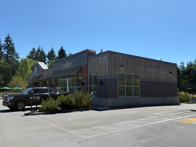
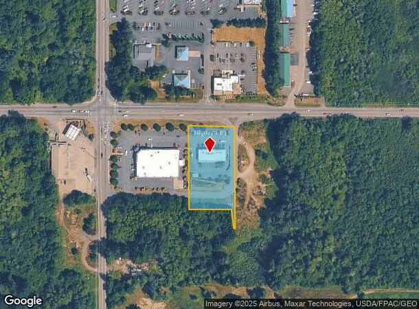
8211 Ne State Highway 104 Hwy, Kingston, WA 98346
This Property Is For Sale
Current Lease Availabilities
NEARBY LISTINGS FOR SALE OR LEASE
Property Detail
8211 Ne State Highway 104 Hwy
Bremerton-Silverdale, WA
Sp#7278
272702-2-045-2005
LOT B OF SHORT PLAT NO. 7278, RECORDED UNDER AUDITORS FILE NOS. 200511300408 AND 200511300409, IN VOLUME 19 OF SHORT PLATS, PAGES 3 AND 4, RECORDS OF KITSAP COUNTY, WASHINGTON, BEING A PORTION OF THE NORTHWEST QUARTER OF THE NOTHWEST QUARTER, SECTION
Storebuilding
Kitsap
X
Washington
53031C0970C
b
2025
1.32 AC
2026
North Kitsap County
090102
Bremerton/Silverdale
4,200 SF
DEMOGRAPHICS near 8211 Ne State Highway 104 Hwy
1 Mile
3 Mile
5 Mile
2024 Total Population
684
7,059
16,402
2029 Population
678
6,986
16,182
Pop Growth 2024-2029
(0.88%)
(1.03%)
(1.34%)
Average Age
44
44
45
2024 Total Households
267
2,793
6,495
HH Growth 2024-2029
(0.75%)
(1.04%)
(1.34%)
Median Household Inc
$99,631
$103,993
$96,285
Avg Household Size
2.50
2.40
2.50
2024 Avg HH Vehicles
2.00
2.00
2.00
Median Home Value
$640,511
$637,536
$592,920
Median Year Built
1988
1988
1988
Nearby Places
- Restaurants
- Banks
- Shops
- Fitness
- Groceries
PUBLIC TRANSPORTATION
COMMUTER RAIL
Edmonds Station (Sounder South Line - Central Puget Sound Regional Transit Authority Rail (Link Light Rail/Sounder))
DRIVE
WALK
Distance
Edmonds Station (Sounder South Line - Central Puget Sound Regional Transit Authority Rail (Link Light Rail/Sounder))
32 min
8.4 mi
AIRPORT
Seattle Paine Field International
DRIVE
WALK
Distance
Seattle Paine Field International
54 min
19.4 mi
Seattle-Tacoma International
DRIVE
WALK
Distance
Seattle-Tacoma International
79 min
39.2 mi
Freight Ports
Port of Seattle
DRIVE
WALK
Distance
Port of Seattle
66 min
29.7 mi
Nearby Properties
Address
Land Use
TOTAL SIZE
Lot Size
Zoning
Address
Land Use
TOTAL SIZE
Lot Size
Zoning
72,735 SF
5.72 AC
UH
Address
Land Use
TOTAL SIZE
Lot Size
Zoning
52,060 SF
15.70 AC
RR
Address
Land Use
TOTAL SIZE
Lot Size
Zoning
55.02 AC
RRUCR
Address
Land Use
TOTAL SIZE
Lot Size
Zoning
1,510 SF
5.15 AC
REC
Address
Land Use
TOTAL SIZE
Lot Size
Zoning
41,892 SF
4.58 AC
NC
Address
Land Use
TOTAL SIZE
Lot Size
Zoning
32,440 SF
3.91 AC
REC
Address
Land Use
TOTAL SIZE
Lot Size
Zoning
33,232 SF
3.44 AC
C
Address
Land Use
TOTAL SIZE
Lot Size
Zoning
29,570 SF
4.89 AC
UL
Address
Land Use
TOTAL SIZE
Lot Size
Zoning
22,879 SF
2.99 AC
C
Address
Land Use
TOTAL SIZE
Lot Size
Zoning
7,092 SF
0.90 AC
UM
Address
Land Use
TOTAL SIZE
Lot Size
Zoning
15,414 SF
1.49 AC
UM
Address
Land Use
TOTAL SIZE
Lot Size
Zoning
17,664 SF
2.11 AC
UL
Address
Land Use
TOTAL SIZE
Lot Size
Zoning
18,187 SF
2.16 AC
NC
Address
Land Use
TOTAL SIZE
Lot Size
Zoning
9,933 SF
0.98 AC
NC
Address
Land Use
TOTAL SIZE
Lot Size
Zoning
57,386 SF
7.70 AC
REC
Address
Land Use
TOTAL SIZE
Lot Size
Zoning
9,750 SF
1.11 AC
NC
Address
Land Use
TOTAL SIZE
Lot Size
Zoning
30,755 SF
1.15 AC
NC
Address
Land Use
TOTAL SIZE
Lot Size
Zoning
5.90 AC
REC
Address
Land Use
TOTAL SIZE
Lot Size
Zoning
22,400 SF
4.11 AC
REC
Address
Land Use
TOTAL SIZE
Lot Size
Zoning
9,064 SF
15.07 AC
RR
Address
Land Use
TOTAL SIZE
Lot Size
Zoning
6,450 SF
0.90 AC
NC
Address
Land Use
TOTAL SIZE
Lot Size
Zoning
10,560 SF
0.85 AC
REC
Address
Land Use
TOTAL SIZE
Lot Size
Zoning
5,327 SF
31.03 AC
RP
Address
Land Use
TOTAL SIZE
Lot Size
Zoning
14,436 SF
1.18 AC
C
Address
Land Use
TOTAL SIZE
Lot Size
Zoning
2,705 SF
1.59 AC
C
Address
Land Use
TOTAL SIZE
Lot Size
Zoning
5,027 SF
16.56 AC
RR
Address
Land Use
TOTAL SIZE
Lot Size
Zoning
2,654 SF
0.76 AC
C
Address
Land Use
TOTAL SIZE
Lot Size
Zoning
10,979 SF
0.38 AC
UVC
Address
Land Use
TOTAL SIZE
Lot Size
Zoning
4,317 SF
2 AC
RP
The World's #1 Commercial Real Estate Marketplace
Connect with us
© 2025 CoStar Group
The information above has been obtained from sources believed reliable. While we do not doubt its accuracy we have not verified it and make no guarantee, warranty or representation about it. It is your responsibility to independently confirm its accuracy and completeness. Any projections, opinions, assumptions, or estimates used are for example only and do not represent the current or future performance of the property. The value of this transaction to you depends on tax and other factors which should be evaluated by your tax, financial, and legal advisors. You and your advisors should conduct a careful, independent investigation of the property to determine to your satisfaction the suitability of the property for your needs.