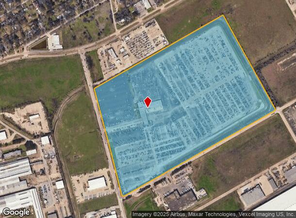
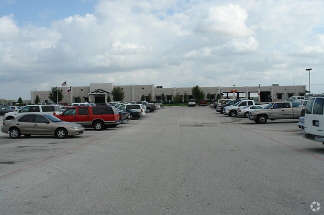
Property Record
8215 Kopman Dr, Houston, TX 77061

NEARBY LISTINGS FOR SALE OR LEASE
Property Detail
8215 Kopman Dr
1197090010001
Central Industrial Park Sec 9
Outdoorrecreationbeachmountaindesert
RES A BLK 1 CENTRAL INDUSTRIAL PARK SEC 9
X
Harris
48201C0895N
Texas
2024
79.61 AC
2025
South Hwy 35
333700
Houston
45,038 SF
Houston-The Woodlands-Sugar Land, TX
DEMOGRAPHICS near 8215 Kopman Dr
1 Mile
3 Mile
5 Mile
2024 Total Population
2,631
89,431
286,375
2029 Population
2,734
92,384
294,634
Pop Growth 2024-2029
+ 3.91%
+ 3.30%
+ 2.88%
Average Age
38
37
36
2024 Total Households
847
29,685
95,545
HH Growth 2024-2029
+ 3.66%
+ 3.34%
+ 2.93%
Median Household Inc
$65,517
$43,640
$45,592
Avg Household Size
3.00
2.90
2.90
2024 Avg HH Vehicles
2.00
2.00
2.00
Median Home Value
$210,215
$141,714
$150,358
Median Year Built
1958
1970
1971
Nearby Places
Map Layers
Map Styles
 Street
 Aerial
- Restaurants
- Banks
- Shops
- Fitness
- Groceries
PUBLIC TRANSPORTATION
AIRPORT
William P Hobby
DRIVE
WALK
Distance
William P Hobby
12 min
4.1 mi
George Bush Intcntl/Houston
DRIVE
WALK
Distance
George Bush Intcntl/Houston
43 min
31.9 mi
Freight Ports
Port of Houston
DRIVE
WALK
Distance
Port of Houston
19 min
9.3 mi
Nearby Properties
Address
Land Use
TOTAL SIZE
Lot Size
Zoning
Address
Land Use
TOTAL SIZE
Lot Size
Zoning
1,226,700 SF
92.85 AC
Address
Land Use
TOTAL SIZE
Lot Size
Zoning
589,830 SF
47.20 AC
Address
Land Use
TOTAL SIZE
Lot Size
Zoning
389,108 SF
37.39 AC
Address
Land Use
TOTAL SIZE
Lot Size
Zoning
556,568 SF
20 AC
Address
Land Use
TOTAL SIZE
Lot Size
Zoning
188,110 SF
2.22 AC
Address
Land Use
TOTAL SIZE
Lot Size
Zoning
196,000 SF
29.42 AC
Address
Land Use
TOTAL SIZE
Lot Size
Zoning
239,458 SF
15.57 AC
Address
Land Use
TOTAL SIZE
Lot Size
Zoning
210,476 SF
9.60 AC
Address
Land Use
TOTAL SIZE
Lot Size
Zoning
291,181 SF
11.07 AC
Address
Land Use
TOTAL SIZE
Lot Size
Zoning
391,576 SF
19.94 AC
Address
Land Use
TOTAL SIZE
Lot Size
Zoning
367,096 SF
15.76 AC
Address
Land Use
TOTAL SIZE
Lot Size
Zoning
353,676 SF
19.86 AC
Address
Land Use
TOTAL SIZE
Lot Size
Zoning
284,290 SF
20 AC
Address
Land Use
TOTAL SIZE
Lot Size
Zoning
433,760 SF
52.70 AC
Address
Land Use
TOTAL SIZE
Lot Size
Zoning
113,688 SF
4 AC
Address
Land Use
TOTAL SIZE
Lot Size
Zoning
164,515 SF
Address
Land Use
TOTAL SIZE
Lot Size
Zoning
257,481 SF
9.28 AC
Address
Land Use
TOTAL SIZE
Lot Size
Zoning
228,900 SF
3.85 AC
Address
Land Use
TOTAL SIZE
Lot Size
Zoning
165,880 SF
19.20 AC
Address
Land Use
TOTAL SIZE
Lot Size
Zoning
244,134 SF
9.44 AC
Address
Land Use
TOTAL SIZE
Lot Size
Zoning
85,323 SF
37.81 AC
Address
Land Use
TOTAL SIZE
Lot Size
Zoning
235,982 SF
9.19 AC
Address
Land Use
TOTAL SIZE
Lot Size
Zoning
418,210 SF
21.42 AC
Address
Land Use
TOTAL SIZE
Lot Size
Zoning
241,219 SF
8.92 AC
Address
Land Use
TOTAL SIZE
Lot Size
Zoning
155,657 SF
3.59 AC
Address
Land Use
TOTAL SIZE
Lot Size
Zoning
71,340 SF
47.16 AC
Address
Land Use
TOTAL SIZE
Lot Size
Zoning
215,004 SF
7.76 AC
Address
Land Use
TOTAL SIZE
Lot Size
Zoning
210,628 SF
9.54 AC
Address
Land Use
TOTAL SIZE
Lot Size
Zoning
210,332 SF
11 AC
The World's #1 Commercial Real Estate Marketplace
Connect with us
© 2026 CoStar Group
The information above has been obtained from sources believed reliable. While we do not doubt its accuracy we have not verified it and make no guarantee, warranty or representation about it. It is your responsibility to independently confirm its accuracy and completeness. Any projections, opinions, assumptions, or estimates used are for example only and do not represent the current or future performance of the property. The value of this transaction to you depends on tax and other factors which should be evaluated by your tax, financial, and legal advisors. You and your advisors should conduct a careful, independent investigation of the property to determine to your satisfaction the suitability of the property for your needs.