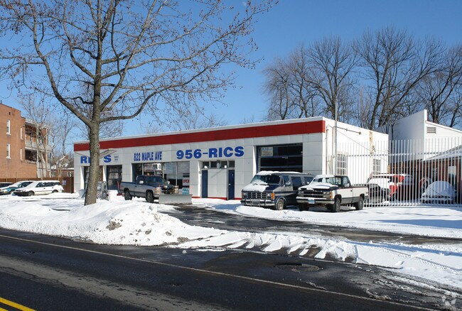
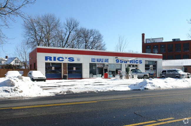
Property Record
822 Maple Ave, Hartford, CT 06114

Property Detail
822 Maple Ave
HTFD-000231-000662-000057
Capitol
Autorepair
Connecticut
MS-2
57
B and X Area of moderate flood hazard, usually the area between the limits of the 100-year and 500-year floods.
0.47 AC
2024
Hartford
2025
Hartford
502300
Hartford-West Hartford-East Hartford, CT
2,230 SF
NEARBY LISTINGS FOR SALE OR LEASE
DEMOGRAPHICS near 822 Maple Ave
1 mile
3 mile
5 mile
2025 Total Population
32,845
145,172
275,220
2030 Population
32,860
147,579
279,530
Pop Growth 2025-2030
+ 0.05%
+ 1.66%
+ 1.57%
Average Age
36
38
40
2025 Total Households
11,570
60,692
111,876
HH Growth 2025-2030
(0.04%)
+ 1.87%
+ 1.69%
Median Household Inc
$46,430
$57,039
$70,765
Avg Household Size
2.60
2.30
2.30
2025 Avg HH Vehicles
1.00
1.00
1.00
Median Home Value
$246,331
$272,042
$299,703
Median Year Built
1947
1952
1956
Nearby Places
Map Layers
Map Styles
 Street
 Aerial
Layers
 Traffic
 Biking
Places
Listings with unknown addresses are not visible on the map
- Restaurants
- Banks
- Shops
- Fitness
- Groceries
PUBLIC TRANSPORTATION
COMMUTER RAIL
Drive
Walk
Distance
5 min
2.5 mi
Drive
Walk
Distance
5 min
2.6 mi
AIRPORT
Bradley International
Drive
Walk
Distance
Bradley International
35 min
19.5 mi
Tweed/New Haven
Drive
Walk
Distance
Tweed/New Haven
52 min
37.6 mi
Freight Ports
Port of New Haven
Drive
Walk
Distance
Port of New Haven
48 min
35.3 mi
SALE & LEASE HISTORY
LISTING DATE
SALE/LEASE

Oct 11, 2016
For Sale
Apr 05, 2018
For Sale
Nearby Properties
Address
Land Use
TOTAL SIZE
Lot Size
Zoning
Address
Land Use
TOTAL SIZE
Lot Size
Zoning
147,644 SF
0.19 AC
CAMP
Address
Land Use
TOTAL SIZE
Lot Size
Zoning
173,601 SF
1.56 AC
DT-1
Address
Land Use
TOTAL SIZE
Lot Size
Zoning
516,804 SF
32.98 AC
CAMP
Address
Land Use
TOTAL SIZE
Lot Size
Zoning
482,566 SF
0.65 AC
DT-2
Address
Land Use
TOTAL SIZE
Lot Size
Zoning
15.73 AC
CAMP
Address
Land Use
TOTAL SIZE
Lot Size
Zoning
4.13 AC
DT-1
Address
Land Use
TOTAL SIZE
Lot Size
Zoning
1.45 AC
CAMP
Address
Land Use
TOTAL SIZE
Lot Size
Zoning
213,017 SF
6.21 AC
DT-3
Address
Land Use
TOTAL SIZE
Lot Size
Zoning
149.23 AC
DDD1
Address
Land Use
TOTAL SIZE
Lot Size
Zoning
2.90 AC
DT-2
Address
Land Use
TOTAL SIZE
Lot Size
Zoning
69.42 AC
CT R
Address
Land Use
TOTAL SIZE
Lot Size
Zoning
8.89 AC
MX-2
Address
Land Use
TOTAL SIZE
Lot Size
Zoning
29.35 AC
CAMP
Address
Land Use
TOTAL SIZE
Lot Size
Zoning
1,125,149 SF
1.14 AC
DT-1
Address
Land Use
TOTAL SIZE
Lot Size
Zoning
205,719 SF
12.15 AC
MX-2
Address
Land Use
TOTAL SIZE
Lot Size
Zoning
3,605 SF
28.33 AC
R-6,RM
Address
Land Use
TOTAL SIZE
Lot Size
Zoning
28.02 AC
CAMP
Address
Land Use
TOTAL SIZE
Lot Size
Zoning
9.92 AC
DDD1
Address
Land Use
TOTAL SIZE
Lot Size
Zoning
416,762 SF
20 AC
CAMP
Address
Land Use
TOTAL SIZE
Lot Size
Zoning
14.56 AC
SDD/BG
Address
Land Use
TOTAL SIZE
Lot Size
Zoning
20.41 AC
MX-2
Address
Land Use
TOTAL SIZE
Lot Size
Zoning
235,476 SF
198.32 AC
CT R
Address
Land Use
TOTAL SIZE
Lot Size
Zoning
197,704 SF
1.82 AC
CAMP
Address
Land Use
TOTAL SIZE
Lot Size
Zoning
109,276 SF
11 AC
DDD1
Address
Land Use
TOTAL SIZE
Lot Size
Zoning
40,632 SF
1.10 AC
NX-1
Address
Land Use
TOTAL SIZE
Lot Size
Zoning
4.76 AC
MX-2
Address
Land Use
TOTAL SIZE
Lot Size
Zoning
6.63 AC
DT-1
Address
Land Use
TOTAL SIZE
Lot Size
Zoning
2.13 AC
DT-1
Address
Land Use
TOTAL SIZE
Lot Size
Zoning
4.50 AC
DT-1
Address
Land Use
TOTAL SIZE
Lot Size
Zoning
254,786 SF
36 AC
A
The World's #1 Commercial Real Estate Marketplace
Connect with us
© 2026 CoStar Group
The information above has been obtained from sources believed reliable. While we do not doubt its accuracy we have not verified it and make no guarantee, warranty or representation about it. It is your responsibility to independently confirm its accuracy and completeness. Any projections, opinions, assumptions, or estimates used are for example only and do not represent the current or future performance of the property. The value of this transaction to you depends on tax and other factors which should be evaluated by your tax, financial, and legal advisors. You and your advisors should conduct a careful, independent investigation of the property to determine to your satisfaction the suitability of the property for your needs.