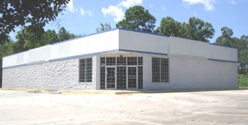
Property Record
822 N 1St St, Jesup, GA 31545
NEARBY LISTINGS FOR SALE OR LEASE
Property Detail
822 N 1St St
Jesup, GA
Ff - 1800
J3-1-4
Wayne
Storebuilding
Georgia
X
0.85 AC
13305C0232C
Georgia South Area
6,764 SF
Other Market Areas
DEMOGRAPHICS near 822 N 1St St
1 Mile
3 Mile
5 Mile
2024 Total Population
2,173
11,807
19,323
2029 Population
2,297
12,315
20,227
Pop Growth 2024-2029
+ 5.71%
+ 4.30%
+ 4.68%
Average Age
39
40
40
2024 Total Households
857
4,298
6,986
HH Growth 2024-2029
+ 5.83%
+ 4.37%
+ 4.80%
Median Household Inc
$42,340
$46,054
$44,216
Avg Household Size
2.40
2.40
2.50
2024 Avg HH Vehicles
2.00
2.00
2.00
Median Home Value
$81,547
$130,012
$131,599
Median Year Built
1968
1975
1982
Nearby Places
Map Layers
Map Styles
 Street
 Aerial
- Restaurants
- Banks
- Shops
- Fitness
- Groceries
PUBLIC TRANSPORTATION
COMMUTER RAIL
Jesup Amtrak Station (Silver Meteor - Amtrak)
DRIVE
WALK
Distance
Jesup Amtrak Station (Silver Meteor - Amtrak)
2 min
0.9 mi
Freight Ports
Georgia Ports - Brunswick
DRIVE
WALK
Distance
Georgia Ports - Brunswick
65 min
45.9 mi
SALE & LEASE HISTORY
LISTING DATE
SALE/LEASE

Sep 03, 2019
For Lease
Nov 13, 2020
For Lease
Nov 13, 2020
For Sale
Nearby Properties
Address
Land Use
TOTAL SIZE
Lot Size
Zoning
Address
Land Use
TOTAL SIZE
Lot Size
Zoning
196,000 SF
56.48 AC
Address
Land Use
TOTAL SIZE
Lot Size
Zoning
270,200 SF
72 AC
Address
Land Use
TOTAL SIZE
Lot Size
Zoning
131,475 SF
19.09 AC
Address
Land Use
TOTAL SIZE
Lot Size
Zoning
147,829 SF
17.80 AC
Address
Land Use
TOTAL SIZE
Lot Size
Zoning
3,696 SF
10.33 AC
Address
Land Use
TOTAL SIZE
Lot Size
Zoning
41,400 SF
10 AC
Address
Land Use
TOTAL SIZE
Lot Size
Zoning
63,555 SF
51.54 AC
Address
Land Use
TOTAL SIZE
Lot Size
Zoning
56,413 SF
2.74 AC
Address
Land Use
TOTAL SIZE
Lot Size
Zoning
26,140 SF
10 AC
Address
Land Use
TOTAL SIZE
Lot Size
Zoning
Address
Land Use
TOTAL SIZE
Lot Size
Zoning
58,162 SF
4.05 AC
Address
Land Use
TOTAL SIZE
Lot Size
Zoning
13,438 SF
1.46 AC
Address
Land Use
TOTAL SIZE
Lot Size
Zoning
21,275 SF
0.51 AC
Address
Land Use
TOTAL SIZE
Lot Size
Zoning
10,230 SF
0.84 AC
Address
Land Use
TOTAL SIZE
Lot Size
Zoning
12,402 SF
2.02 AC
Address
Land Use
TOTAL SIZE
Lot Size
Zoning
43,882 SF
0.92 AC
Address
Land Use
TOTAL SIZE
Lot Size
Zoning
32,280 SF
2.40 AC
Address
Land Use
TOTAL SIZE
Lot Size
Zoning
10,344 SF
10 AC
Address
Land Use
TOTAL SIZE
Lot Size
Zoning
19,050 SF
4.42 AC
Address
Land Use
TOTAL SIZE
Lot Size
Zoning
10,712 SF
1.28 AC
Address
Land Use
TOTAL SIZE
Lot Size
Zoning
7,744 SF
8.16 AC
Address
Land Use
TOTAL SIZE
Lot Size
Zoning
92,414 SF
14.27 AC
Address
Land Use
TOTAL SIZE
Lot Size
Zoning
14,544 SF
5.74 AC
Address
Land Use
TOTAL SIZE
Lot Size
Zoning
19,064 SF
1.35 AC
Address
Land Use
TOTAL SIZE
Lot Size
Zoning
14,080 SF
4.21 AC
Address
Land Use
TOTAL SIZE
Lot Size
Zoning
6,600 SF
2.16 AC
Address
Land Use
TOTAL SIZE
Lot Size
Zoning
1,824 SF
1.84 AC
Address
Land Use
TOTAL SIZE
Lot Size
Zoning
13,600 SF
0.92 AC
Address
Land Use
TOTAL SIZE
Lot Size
Zoning
9,614 SF
0.84 AC
Address
Land Use
TOTAL SIZE
Lot Size
Zoning
6,177 SF
0.93 AC
The World's #1 Commercial Real Estate Marketplace
Connect with us
© 2026 CoStar Group
The information above has been obtained from sources believed reliable. While we do not doubt its accuracy we have not verified it and make no guarantee, warranty or representation about it. It is your responsibility to independently confirm its accuracy and completeness. Any projections, opinions, assumptions, or estimates used are for example only and do not represent the current or future performance of the property. The value of this transaction to you depends on tax and other factors which should be evaluated by your tax, financial, and legal advisors. You and your advisors should conduct a careful, independent investigation of the property to determine to your satisfaction the suitability of the property for your needs.