Property Record
822 Ne San Kar Dr, Grain Valley, MO 64029

NEARBY LISTINGS FOR SALE OR LEASE
-
-
View all Grain Valley listings for sale on LoopNet.com
Property Detail
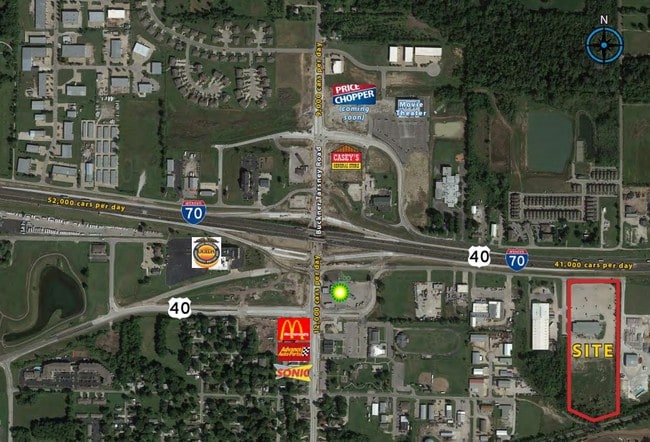
822 Ne San Kar Dr
Kansas City, MO-KS
I-70 East Industrial Park
37-800-01-44-00-0-00-000
I-70 EAST INDUSTRIAL PARK LOT 1 (EX N 75 OF E 39 THOF) & A LL LOT 2 & LOTS 3-6 I-70 EAST INDUSTRIAL PARK-PHASE TWO
Miscellaneous
Jackson
AE
Missouri
29095C0339G
1
2024
12.44 AC
2025
East Jackson County
014008
Kansas City
24,940 SF
DEMOGRAPHICS near 822 Ne San Kar Dr
1 Mile
3 Mile
5 Mile
2024 Total Population
2,800
21,033
60,138
2029 Population
2,846
21,003
59,651
Pop Growth 2024-2029
+ 1.64%
(0.14%)
(0.81%)
Average Age
35
37
38
2024 Total Households
1,100
7,501
22,082
HH Growth 2024-2029
+ 1.45%
(0.25%)
(0.91%)
Median Household Inc
$73,867
$85,366
$80,675
Avg Household Size
2.50
2.80
2.70
2024 Avg HH Vehicles
2.00
2.00
2.00
Median Home Value
$181,440
$244,072
$232,845
Median Year Built
2001
2000
1990
Nearby Places
Map Layers
Map Styles
 Street
 Aerial
- Restaurants
- Banks
- Shops
- Fitness
- Groceries
PUBLIC TRANSPORTATION
AIRPORT
Kansas City International
DRIVE
WALK
Distance
Kansas City International
57 min
43.3 mi
SALE & LEASE HISTORY
LISTING DATE
SALE/LEASE

Aug 14, 2017
For Sale
Nearby Properties
Address
Land Use
TOTAL SIZE
Lot Size
Zoning
Address
Land Use
TOTAL SIZE
Lot Size
Zoning
584,820 SF
38 AC
Address
Land Use
TOTAL SIZE
Lot Size
Zoning
255,288 SF
25.67 AC
Address
Land Use
TOTAL SIZE
Lot Size
Zoning
321,331 SF
55.69 AC
Address
Land Use
TOTAL SIZE
Lot Size
Zoning
430,717 SF
69.75 AC
Address
Land Use
TOTAL SIZE
Lot Size
Zoning
74,031 SF
0.02 AC
Address
Land Use
TOTAL SIZE
Lot Size
Zoning
42,176 SF
22.04 AC
Address
Land Use
TOTAL SIZE
Lot Size
Zoning
93,336 SF
11.67 AC
Address
Land Use
TOTAL SIZE
Lot Size
Zoning
89,766 SF
16.50 AC
Address
Land Use
TOTAL SIZE
Lot Size
Zoning
80,458 SF
0.40 AC
Address
Land Use
TOTAL SIZE
Lot Size
Zoning
58,390 SF
10.10 AC
Address
Land Use
TOTAL SIZE
Lot Size
Zoning
67,986 SF
9.88 AC
Address
Land Use
TOTAL SIZE
Lot Size
Zoning
110,829 SF
20.78 AC
Address
Land Use
TOTAL SIZE
Lot Size
Zoning
59,584 SF
4.44 AC
Address
Land Use
TOTAL SIZE
Lot Size
Zoning
26,869 SF
3.08 AC
Address
Land Use
TOTAL SIZE
Lot Size
Zoning
70,158 SF
4.74 AC
Address
Land Use
TOTAL SIZE
Lot Size
Zoning
1,154 SF
160 AC
Address
Land Use
TOTAL SIZE
Lot Size
Zoning
27,585 SF
3.94 AC
Address
Land Use
TOTAL SIZE
Lot Size
Zoning
166,923 SF
87 AC
Address
Land Use
TOTAL SIZE
Lot Size
Zoning
57,430 SF
Address
Land Use
TOTAL SIZE
Lot Size
Zoning
95,384 SF
5.91 AC
Address
Land Use
TOTAL SIZE
Lot Size
Zoning
65,178 SF
6.75 AC
Address
Land Use
TOTAL SIZE
Lot Size
Zoning
28,576 SF
21.38 AC
Address
Land Use
TOTAL SIZE
Lot Size
Zoning
35.79 AC
Address
Land Use
TOTAL SIZE
Lot Size
Zoning
28,325 SF
6 AC
Address
Land Use
TOTAL SIZE
Lot Size
Zoning
129,600 SF
9.70 AC
Address
Land Use
TOTAL SIZE
Lot Size
Zoning
5,544 SF
Address
Land Use
TOTAL SIZE
Lot Size
Zoning
123,260 SF
7.32 AC
Address
Land Use
TOTAL SIZE
Lot Size
Zoning
44,413 SF
8.11 AC
Address
Land Use
TOTAL SIZE
Lot Size
Zoning
16,509 SF
9.27 AC
Address
Land Use
TOTAL SIZE
Lot Size
Zoning
50,078 SF
6.60 AC
The World's #1 Commercial Real Estate Marketplace
Connect with us
© 2026 CoStar Group
The information above has been obtained from sources believed reliable. While we do not doubt its accuracy we have not verified it and make no guarantee, warranty or representation about it. It is your responsibility to independently confirm its accuracy and completeness. Any projections, opinions, assumptions, or estimates used are for example only and do not represent the current or future performance of the property. The value of this transaction to you depends on tax and other factors which should be evaluated by your tax, financial, and legal advisors. You and your advisors should conduct a careful, independent investigation of the property to determine to your satisfaction the suitability of the property for your needs.